Salt Lake Avalanche Advisory

Forecaster: Brett Kobernik

BOTTOM LINE

Danger by aspect and elevation on slopes approaching 35° or steeper.
(click HERE for tomorrow's danger rating)


Danger Rose Tutorial

No significant avalanche problems today.


CURRENT CONDITIONS

With benign weather and avalanche conditions we will be only issuing advisories intermittently again as conditions warrant.

Temperatures on Saturday spiked to near 50 at the 6 to 8000 foot level and creeped into the mid 30s at 10000 feet. Ridgetop winds have been from the northwest averaging 10 mph gusting to around 20. The snow surface is a mix of wind, sun, and rime crusts with some patches of soft recrystalized snow thrown in.


RECENT ACTIVITY

Some rollerballing occurred on southerly slopes and minor sluffing could be initiated on the higher northerly aspects. Most slopes outside of the Cottonwood Canyons don't have enough snow to recreate on as well as produce any avalanche danger.

Our attention turns to watching the snow deteriorate into loose sugary crystals which could be our next weak layer once buried. This will be most pronounced on the upper elevation northerly aspects or generally on slopes that won't get affected by a melt freeze process.

Click HERE for some early season thoughts on winter.


THREAT #1

No problem identified.
WHERE PROBABILITY SIZE TREND
No probability identified.
No size identified.
No trend identified.

No significant avalanche problems today.


MOUNTAIN WEATHER

Weather is always the driving force to changing our snowpack anytime during the winter and the current forecast is just the type of weather to turn the snow into faceted crystals. The current ridge of high pressure that is over our area was originally depicted by weather models to be short lived. This does not look like the case now. It appears that the ridge will stay in place through most of the week which will be a long enough period where we will have to seriously evaluate how much the snow is weakened before the next storm. It looks like the ridge will flatten a bit late in the week with the chance for a minor disturbance but there isn't any significant low pressure system portrayed right now.

Temperatures will be warming into Monday and stay mild through the week. Light to moderate speed winds will be from the northwest today shifting to a more southerly direction as the ridge moves over us during the week.


GENERAL ANNOUNCEMENTS

Don't forget about Ski Utah's Fat Flake Festival is today at the Gallivan Center in downtown Salt Lake City. You can click HERE for more information.

If you want to get this avalanche advisory e-mailed to you daily click HERE.

UDOT highway avalanche control work info can be found by calling (801) 975-4838. Our statewide toll free line is 1-888-999-4019 (early morning, option 8).

The UAC depends on contributions from users like you to support our work. To find out more about how you can support our efforts to continue providing the avalanche forecasting and education that you expect please visitour Friends page.

If you’re getting out and see anything we should know about please let us know. You can leave a message at (801) 524-5304 or 1-800-662-4140, or email us at uac@utahavalanchecenter.org. (Fax 801-524-6301)

This advisory will only be updated as conditions change.
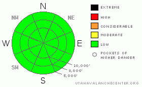

This information does not apply to developed ski areas or highways where avalanche control is normally done.  This advisory is from the U.S.D.A. Forest Service, which is solely responsible for its content. This advisory describes general avalanche conditions and local variations always occur.


This advisory provided by the USDA Forest Service, in partnership with:

The Friends of the Utah Avalanche Center, Utah Division of State Parks and Recreation, Utah Division of Emergency Management, Salt Lake County, Salt Lake Unified Fire Authority and the friends of the La Sal Avalanche Center. See our Sponsors Page for a complete list.