BOTTOM LINE
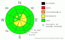
Danger by aspect and elevation on slopes approaching 35° or steeper.
(click HERE for tomorrow's danger rating)
|
Danger Rose Tutorial
|
The avalanche danger is MODERATE on slopes approaching 35 degrees or steeper with recent drifts of wind blown snow. Because of the strong winds, you could find these drifts on a wide variety of slopes but mostly near the upper elevation ridges on south through east facing slopes. Places out of the wind and places with a strongly refrozen snow surface will be LOW danger. |
|
|
CURRENT CONDITIONS |

|
Yesterday, maybe it was the gloomy weather and the crazy-winds. But it put everyone in a foul mood, including both me and the snowpack. It rained fairly hard yesterday to around 9,500 feet with a rime crust above that elevation. Then, 8,000' temperatures dropped to 25 this morning, so the snow surface might resemble concrete traffic barriers with wet snow underneath. If that's not enough, it blew very hard overnight from the northwest. On the highest peaks, the wind blew with hourly averages of 74 with a gust to 111, but it was a more reasonable 35 mph on most ridge tops with gusts to 55. This morning, the winds have dropped to 10, gusting to 20. |
|
|
RECENT ACTIVITY |

|
Yesterday, you could find some slabby, cracking snow along the ridges and there was one shallow, soft slab from an explosive above 10,500' in Little Cottonwood Canyon. But most of the wind damage occurred overnight, so we don't yet know how how bad it was. |
|
|
THREAT #1 |

|
| WHERE |
PROBABILITY |
SIZE |
TREND |

|
|
|
|
| |
|
|
Over the next
24
hours.
|
|
|
The main avalanche concern today will obviously be wind slabs from the very strong winds overnight. Strong winds and high humidity create hard slabs, which are especially tricky because some may be so strong you can hardly kick a boot into them. And since they were deposited just last night, they could be sensitive to the weight of a person. Because the winds were so strong, you will likely find them well down off the ridges in unusual places. Today you should definitely avoid slopes approaching 35 degrees of steeper with recent deposits of wind drifted snow. These will look smooth and rounded and could range from soft to very hard and you will find them mostly along the upper elevation ridges.
The only good news from this recent rain is that it will likely limit the development of the dreaded faceted snow during these next week of clear weather. |
|
|
MOUNTAIN WEATHER |

|
We should have mostly sunny day today and more of the same for the next several days. Today, 8,000' temperatures should rise to the mid 30's with an overnight low tonight in the mid teens. Tonight should be good for a just-past-full moon touring if you don't mind some hard snow. For the extended forecast, we have a strong ridge building over us this weekend and most of next week, which will keep our skies sunny and mountain temperatures very warm. There is a hint of more snow next weekend. |
|
|
GENERAL ANNOUNCEMENTS |
|
Don't forget about Ski Utah's Fat Flake Festival this Saturday at the Gallivan Center in downtown Salt Lake City. You can click HERE for more information.
If you want to get this avalanche advisory e-mailed to you daily click HERE.
UDOT highway avalanche control work info can be found by calling (801) 975-4838. Our statewide toll free line is 1-888-999-4019 (early morning, option 8).
The UAC depends on contributions from users like you to support our work. To find out more about how you can support our efforts to continue providing the avalanche forecasting and education that you expect please visitour Friends page.
If you’re getting out and see anything we should know about please let us know. You can leave a message at (801) 524-5304 or 1-800-662-4140, or email us at uac@utahavalanchecenter.org. (Fax 801-524-6301).
Evelyn Lees will update this advisory by 7:30 on Saturday morning. |
|
|
This information does not apply to developed ski areas or highways where avalanche control is normally done. This advisory is from the U.S.D.A. Forest Service, which is solely responsible for its content. This advisory describes general avalanche conditions and local variations always occur. |
|
This advisory provided by the USDA Forest Service, in partnership with:
The Friends of the Utah Avalanche Center, Utah Division of State Parks and Recreation, Utah Division of Emergency Management, Salt Lake County, Salt Lake Unified Fire Authority and the friends of the La Sal Avalanche Center. See our Sponsors Page for a complete list. |
