SPECIAL ANNOUNCEMENT |
 |
Alta is now closed to uphill traffic as they begin their setup and snow safety operations for the season. |
|
|
BOTTOM LINE
Danger by aspect and elevation on slopes approaching 35° or steeper.
(click HERE for tomorrow's danger rating)
|
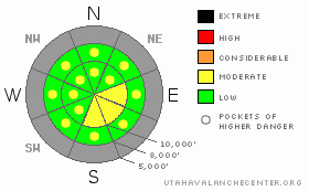
Danger Rose Tutorial
|
Stronger northwest winds will dictate a building MODERATE danger in the high lee today. Sensitive new wind drifts will continue to build with the expectation of continued winds and some snow. Look for wet activity with a rising rain/snow line to 8500' and watch the terrain you're in if newly saturated snow is starting to move. |
|
|
CURRENT CONDITIONS |

|
Sometimes, if you're lucky, you can get a glimpse of something special. Yesterday's partial clearing presented a brilliant sundog - arcing curves of light from when the sun's rays are refracted by ice crystals in the sky. It didn't last long, as the sky filled again with clouds, signalling the arrival of our warm front. Mountain temps rose through the night and are currently in the mid to upper twenties. The northwesterly winds picked up overnight and are blowing 25-30mph with gusts into the mid 40's. These seem to be confined to the highest ridgelines, but will be a player in today's avalanche discussion. The mountains picked up an inch or two this morning and we'll see off and on snow throughout the day. |
|
|
RECENT ACTIVITY |

|
Low density stellars and/or a thin layer of faceted snow from Saturday into Sunday provided the grease for some shallow slab avalanches in steep upper elevation terrain yesterday. These 'graupel slabs' were 2-4” deep and 10-15' wide, but I suppose they'd trip you up if you weren't paying attention. Consequences could be ugly with all sorts of trash sticking out of our young snowpack. |
|
|
THREAT #1 |

|
| WHERE |
PROBABILITY |
SIZE |
TREND |
|
|
|
|
| |
|
|
Over the next
24
hours.
|
|
|
In any event, the pre-existing snow and whatever new snow we receive, will be whipped into sensitive drifts along the upper elevations and most pronounced on the south through east facing aspects. Look for scalloped and rounded, smooth drifts if you're in the high exposed terrain. These should be manageable to avoid or check with a slope cut. |
|
|
MOUNTAIN WEATHER |

|
Snow totals south of I-80 may shape up to be 4-8” with the lion's share going to the Logan mountains. Temps will rise to, or just under, freezing at 10,000' today, with expected northwesterly winds in the 30-35 mph range. A weak cold front moves through on Thursday providing a couple more inches ahead of building high pressure for the weekend. |
|
|
GENERAL ANNOUNCEMENTS |
Join us for dinner and a movie tomorrow at Brewvies Cinema in Salt Lake City for the second annual Boondockers/Thunderstruck premier. Festivities start at 6:30 (food and drink) with the movies rolling at 7:00. Tickets are $10.00 and all proceeds go to the Friends of the UAC for snowmobile specific avalanche awareness programs.
UDOT highway avalanche control work info can be found by calling (801) 975-4838.
Our statewide tollfree line is 1-888-999-4019 (early morning, option 8).
The UAC depends on contributions from users like you to support our work. To find out more about how you can support our efforts to continue providing the avalanche forecasting and education that you expect please visitour Friends page.
If you’re getting out and see anything we should know about please let us know. You can leave a message at (801) 524-5304 or 1-800-662-4140, or email us at uac@avalanche.org. (Fax 801-524-6301).
The information in this advisory is from the U.S. Forest Service, which is solely responsible for its content. This advisory describes general avalanche conditions and local variations always occur.
Evelyn Lees will update this advisory by 7:30 on Thursday morning. |
|
|
This information does not apply to developed ski areas or highways where avalanche control is normally done. This advisory is from the U.S.D.A. Forest Service, which is solely responsible for its content. This advisory describes general avalanche conditions and local variations always occur. |
|
This advisory provided by the USDA Forest Service, in partnership with:
The Friends of the Utah Avalanche Center, Utah Division of State Parks and Recreation, Utah Division of Emergency Management, Salt Lake County, Salt Lake Unified Fire Authority and the friends of the La Sal Avalanche Center. See our Sponsors Page for a complete list. |
