SPECIAL ANNOUNCEMENT |
 |
Alta is now closed to uphill traffic as they begin their setup and snow safety operations for the season.
|
|
|
BOTTOM LINE
Danger by aspect and elevation on slopes approaching 35° or steeper.
(click HERE for tomorrow's danger rating)
|
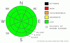
Danger Rose Tutorial
|
The avalanche danger is mostly LOW. You may be able to get some loose snow moving in the highest elevations, particularly along the Ogden skyline, but things are mostly stable. |
|
|
CURRENT CONDITIONS |

|
With all the abundant moisture with this last 'system', it was a cruel joke that little of it translated to snowfall in the mountains. Rain totals in many parts of the valley reached .7” of water to up and over an inch, but it didn't have the drive and instability to be much of a producer. I guess after last Wednesday's storm, anything is bound to be a letdown. The Ogden mountains picked up 4-6”, the Salt Lake mountains 2-4”, and the Provo mountains a trace or two. Winds continue to be westerly and less than about 15mph. Temps are in the mid to low twenties. Riding conditions are best in the upper elevation shady terrain, but with a still-thin snowpack, it's best to look for lower angle terrain with grassy slopes under the 2-3' of settled snow. |
|
|
RECENT ACTIVITY |

|
Not much news in this department. |
|
|
THREAT #1 |

|
| WHERE |
PROBABILITY |
SIZE |
TREND |

|
|
|
|
| |
|
|
Over the next
24
hours.
|
|
|
Minor sluffing in the new snow and isolated cracking in the shallow wind drifts is all you can buy. Rain from early November seems to have capped off or damaged much, if not all, of the early season depth hoar and for now we're looking at a pretty stable 'right-side-up' snowpack. |
|
|
MOUNTAIN WEATHER |

|
We're between 'systems' today. We'll see mostly cloudy skies with light winds and temps in the 20's. A warm front moves through tomorrow that'll be accompanied by stronger northwest winds, ample moisture, and a rising rain-snow line. Precipitation amounts could be 4-7” through Thursday, with rain up to 8500'. Or higher. High pressure builds for the weekend. |
|
|
GENERAL ANNOUNCEMENTS |
Join us for dinner and a movie this Thursday Nov. 13th at Brewvies Cinema in Salt Lake City for the second annual Boondockers/Thunderstruck premier. Festivities start at 6:30 (food and drink) with the movies rolling at 7:00. Tickets are $10.00 and all proceeds go to the Friends of the UAC for snowmobile specific avalanche awareness programs.
As you notice, we are still getting the bugs worked out of our new web site and we hope to have everything working fine and looking spiffier by Thanksgiving. We are still looking for funding to finish the project this winter if you care to donate to the cause.
Our statewide toll free line is 1-888-999-4019 (early morning, option 8).
If you’re getting out and see anything we should know about please let us know. You can leave a message at (801) 524-5304 or 1-800-662-4140, or fill out the observation form on the home page or email us at uac@utahavalanchecenter.org. (Fax 801-524-6301)
I will update this forecast tomorrow. |
|
|
This information does not apply to developed ski areas or highways where avalanche control is normally done. This advisory is from the U.S.D.A. Forest Service, which is solely responsible for its content. This advisory describes general avalanche conditions and local variations always occur. |
|
This advisory provided by the USDA Forest Service, in partnership with:
The Friends of the Utah Avalanche Center, Utah Division of State Parks and Recreation, Utah Division of Emergency Management, Salt Lake County, Salt Lake Unified Fire Authority and the friends of the La Sal Avalanche Center. See our Sponsors Page for a complete list. |
