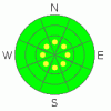
BOTTOM LINE
Danger by aspect and elevation on slopes approaching 35° or steeper.
(click HERE for tomorrow's danger rating)
|

Danger Rose Tutorial
|
Bottom Line for the Salt Lake area mountains:
The avalanche danger is generally LOW. However, there are pockets of MODERATE avalanche danger on steep wind drifted slopes and on steep north through northeast facing slopes above about 10,000', where in isolated places a person could trigger a slide breaking out near the ground.
The Ogden, Park City and Provo area mountains: With less than a foot of snow on the ground, these areas have a generally LOW avalanche danger. However, if you're hiking around or hunting in upper elevation terrain, avoid any steep slopes with deeper drifts of snow, especially gullies. |
|
|
CURRENT CONDITIONS |

|
Under clear skies, temperatures are in the 20's this morning. The northwesterly winds are light, generally less than 15 mph, with only a few of the highest peaks gusting into the 30's.
The upper Cottonwoods are the place to head – even with settlement, the upper elevations still have snow depths of 2 to 4 feet. The Ogden, Provo and Park City area mountains generally have less then a foot of snow on the ground, as do the lower elevations. Unfortunately, sun and a mix of thin clouds nuked the snow surface on many slopes yesterday, resulting in widespread surface crusts this morning, which will soften to mush as the day heats up. A few drainages had thicker cloud cover yesterday, so you can find powder stashes on some steep, upper elevation shady slopes. With a shallow snow pack, there is a high danger of hitting rocks and stumps. |
|
|
RECENT ACTIVITY |

|
No new avalanches were reported from the backcountry yesterday. Of interest is Thursday's avalanche at Snowbird, when it was not yet open to the public. On a steep, heavily wind loaded northerly facing slope above 11,000', a slide released that was 2-3 feet deep and 200 feet wide. The culprit weak layer involved the wet facets and/or ice crust near the ground. |
|
|
THREAT #1 |

|
| WHERE |
PROBABILITY |
SIZE |
TREND |
|
|
|
|
| |
|
|
Over the next
24
hours.
|
|
|
A few lingering wind drifts at the higher elevations and along ridge lines could be triggered by a person. Avoid any steep, wind drifted slope. Also, as the day warms, it may be possible to trigger a few wet sluffs on steep sunny slopes. |
|
|
THREAT #2 |

|
| WHERE |
PROBABILITY |
SIZE |
TREND |
|
|
|
|
| |
|
|
Over the next
24
hours.
|
|
|
There are a very few isolated places where a person could trigger a deeper slide on the ice crust near the ground. This layering is only on shady, upper elevation slopes above about 10,000 feet, especially where wind loaded. |
|
|
MOUNTAIN WEATHER |

|
Skies will be mostly clear this morning, before becoming partly cloudy this afternoon. Temperatures will warm into the low 40’s at 8,000’ and into the mid 30's at 10,000’ today. The winds will remain from the northwest, generally less than 15 mph at most mountain locations, though the highest peaks may have gusts into the 30 mph range. Clouds will start to increase this afternoon ahead of the next approaching storm system. Periods of light snow could begin late tonight, but the heaviest snowfall will start Sunday afternoon as the front pushes through northern Utah. Snow will continue into Monday morning, accompanied by much colder temperatures. |
|
|
GENERAL ANNOUNCEMENTS |
Our statewide toll free line is 1-888-999-4019 (early morning, option 8).
If you’re getting out and see anything we should know about please let us know. You can leave a message at (801) 524-5304 or 1-800-662-4140, or email us at uac@avalanche.org. (Fax 801-524-6301)
The information in this advisory is from the U.S. Forest Service, which is solely responsible for its content. This advisory describes general avalanche conditions and local variations always occur.
Brett Kobernik will update this forecast tomorrow, and thanks for calling. |
|
|
This information does not apply to developed ski areas or highways where avalanche control is normally done. This advisory is from the U.S.D.A. Forest Service, which is solely responsible for its content. This advisory describes general avalanche conditions and local variations always occur. |
|
This advisory provided by the USDA Forest Service, in partnership with:
The Friends of the Utah Avalanche Center, Utah Division of State Parks and Recreation, Utah Division of Emergency Management, Salt Lake County, Salt Lake Unified Fire Authority and the friends of the La Sal Avalanche Center. See our Sponsors Page for a complete list. |
