BOTTOM LINE
Danger by aspect and elevation on slopes approaching 35° or steeper.
(click HERE for tomorrow's danger rating)
|
Danger Rose Tutorial
|
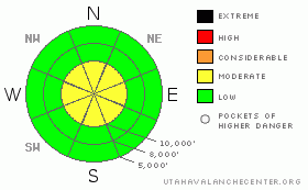
The snow on most aspects and elevations is stable but there are pockets of MODERATE danger along the upper elevation ridges from recent wind slabs and also some pockets of lingering deep slabs along the highest, north through east facing ridges. Avoid steep slopes with recent deposits of wind drifted snow and all steep north through east facing slopes above 11,000'. |
|
|
CURRENT CONDITIONS |

|
First, excuse our dust. As you notice, we have a new web site and we are still trying to get all our bugs worked out over these next couple weeks. By Thanksgiving everything should be working properly. But we are still looking for more funding to finish the job if you care to donate to the Friends of the Utah Avalanche Center.
In the mean time, we have some of the best early season conditions in years, at least in the Salt Lake area mountains where the lake effect snow hammered hard during the last storm. Skiers and boarders in the Cottonwood Canyons are frolicking in over three feet of new snow, which has settled into a supportable base where you almost never hit a rock. After sunny skies and cold temperatures yesterday, it is cloudy this morning with temperatures in the mid 20's. |
|
|
RECENT ACTIVITY |

|
The snowpack is quite solid and most of the lines have been skied or boarded in Little Cottonwood Canyon. However, Snowbird, which was not yet open to the public, reported a large, natural avalanche out of "Old Reliable", yesterday morning, a steep, north facing slope at 11,300'. It was an attention-grabbing, 2-3 feet deep, 200 feet wide and it ran on the interface between the new and old snow. It was also heavily wind loaded from the strong winds on Tuesday night and Wednesday morning. The old snow at that elevation was a thin layer of faceted snow. The rain on Monday soaked the old snow up past 11,000', which destroyed the faceted snow in most areas and perhaps this areas was just a trifle too high, but patrollers reported wet facets on the bed surface. This was the only deep avalanche we heard about and we hope that it is an outlier.
Also, the north and northwest winds blew fairly hard yesterday, which created some wind damage and wind slabs along the upper elevation ridges above about 10,500'. Many people reported cracking snow and fresh cornices but only minor wind slab activity. But you should still avoid steep slopes with fresh deposits of wind drifted snow along the high ridges today |
|
|
THREAT #1 |

|
| WHERE |
PROBABILITY |
SIZE |
TREND |

|
|
|
|
| |
|
|
Over the next
24
hours.
|
|
|
Watch for lingering wind slabs along the upper elevation ridges from moderate to strong winds yesterday from the north and northwest. These winds loaded slopes primarily facing south through east but they could be cross loaded into other slopes as well. |
|
|
THREAT #2 |

|
| WHERE |
PROBABILITY |
SIZE |
TREND |

|
|
|
|
| |
|
|
Over the next
24
hours.
|
|
|
There is still a possibility of deep avalanches 2-3 feet deep along the highest ridges, especially on the north through east facing slopes sliding on the old layer of faceted snow left over from before the storm. It's probably best to avoid these areas. |
|
|
MOUNTAIN WEATHER |

|
We should have mostly cloudy skies this morning turning to partly cloudy skies this afternoon. Temperatures should rise into the lower 30's and ridge top winds will remain light to moderate from the northwest and north.
The extended forecast calls for another storm on Sunday and Monday and a series of storms lined up after that. It looks like we are in for a great early season. |
|
|
GENERAL ANNOUNCEMENTS |
Our statewide toll free line is 1-888-999-4019.
If you’re getting out and see anything we should know about please let us know. You can leave a message at (801) 524-5304 or 1-800-662-4140, or email us at uac@utahavalanchecenter.org. (Fax 801-524-6301) |
|
|
This information does not apply to developed ski areas or highways where avalanche control is normally done. This advisory is from the U.S.D.A. Forest Service, which is solely responsible for its content. This advisory describes general avalanche conditions and local variations always occur. |
|
This advisory provided by the USDA Forest Service, in partnership with:
The Friends of the Utah Avalanche Center, Utah Division of State Parks and Recreation, Utah Division of Emergency Management, Salt Lake County, Salt Lake Unified Fire Authority and the friends of the La Sal Avalanche Center. See our Sponsors Page for a complete list. |
