SPECIAL ANNOUNCEMENT |
 |
The unopened resorts are not doing control work and must be treated as backcountry terrain. Please respect any closures the resorts have as they do early season work.
|
|
|
BOTTOM LINE
Danger by aspect and elevation on slopes approaching 35° or steeper.
(click HERE for tomorrow's danger rating)
|
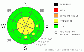
Danger Rose Tutorial
|
Bottom Line for the Salt Lake and Park City mountains:
The avalanche danger is MODERATE on steep, wind drifted slopes. These drifts will be most common along the higher ridge lines, and could be easily triggered on steep slopes. If the winds persist today, both the depth and extent of the drifts will increase. Remember, any ride you take in an avalanche this time of year has the potential to be a rocky one due to the shallow snow pack. The Provo and Ogden area mountains: have a generally low danger due to the limited amount of snow. However, if you're hiking around at the upper elevations, watch out for and avoid any drifts of wind blown snow.
|
|
|
CURRENT CONDITIONS |

|
It may be called the “Dreaded Lake Effect” by people down in the valley, but up in the mountains a completely different attitude calls it the “Awesome Lake Effect”! (Photo) With a few additional inches of snow overnight, storm totals range from 2 feet to 4 feet, with the higher numbers above about 9,500' in upper Big and Little Cottonwood. (Snow Profiles) The Ogden and Provo areas mountains generally have about 6 to 12” of snow on the ground, with higher amounts in a few locations. Temperatures this morning have dropped into the single digits to low teens. Combine that with the 15 mph northwesterly winds, it will feel more like minus 10. Settlement throughout the day should help the wallowing conditions that existed in some areas yesterday. Drew has created a map with current snow and weather information, that will continue to be populated with profiles, accident data, and avalanches. A 'legend' is on the map. Click HERE to see it.
|
|
|
RECENT ACTIVITY |

|
Avalanche activity yesterday included some spontaneous avalanches during the periods of highest precipitation rates. People were able to trigger both sluffs and shallow soft slabs on steep terrain in the upper elevations. Most of these were just large enough to tip you over or carry for a short distance.
|
|
|
THREAT #1 |

|
| WHERE |
PROBABILITY |
SIZE |
TREND |

|
|
|
|
| |
|
|
Over the next
24
hours.
|
|
|
Today, watch out for sensitive drifts of snow created by the persistent northwesterly winds. While most mountain stations are currently averaging less than 15 mph, speeds across the highest peaks are in the 30's, with gusts to 50 mph. With tons of light snow available for transport, soft drifts will rapidly build along the windy ridge lines, and at mid slope breakovers and subridges. If the winds increase where you are today, back off the steep slopes. Cracking in the surface snow is a sign that you're in an area of wind drifted snow.
|
|
|
MOUNTAIN WEATHER |

|
A northwesterly flow will remain over the area through Friday night, with enough moisture to create partly cloudy skies. Today, the northwesterly winds will increase into the 15 to 25 mph range, with gusts to 30, at the 9 to 10,000' elevations. Speeds across the highest peaks will reach 25 to 35 mph, with gusts in the 50's. Temperatures will be slow to warm, with 8,000' highs only in the upper 20's. There will be a slow warming trend for Friday and Saturday ahead of the next storm system, which is expected to bring snow late Saturday night through Sunday.
|
|
|
GENERAL ANNOUNCEMENTS |
Our statewide toll free line is 1-888-999-4019.
If you’re getting out and see anything we should know about please let us know. You can leave a message at (801) 524-5304 or 1-800-662-4140, or email us at uac@avalanche.org. (Fax 801-524-6301)
|
|
|
This information does not apply to developed ski areas or highways where avalanche control is normally done. This advisory is from the U.S.D.A. Forest Service, which is solely responsible for its content. This advisory describes general avalanche conditions and local variations always occur. |
|
This advisory provided by the USDA Forest Service, in partnership with:
The Friends of the Utah Avalanche Center, Utah Division of State Parks and Recreation, Utah Division of Emergency Management, Salt Lake County, Salt Lake Unified Fire Authority and the friends of the La Sal Avalanche Center. See our Sponsors Page for a complete list. |
