
In partnership with: Utah Division of State
Parks and Recreation, The Friends of the Utah Avalanche Center, Utah Department
of Emergency Services and Homeland Security and
AVALANCHE ADVISORY
Wednesday,
March 08, 2006 7:30am
Good morning, this is Evelyn Lees with
the
Current Conditions:
An additional 2 to 5” of low density
powder fell over night, and storm totals in the Ogden, Salt Lake and Park City mountains
add up to 10” to 20”, with the higher amounts concentrated in upper Big Cottonwood
canyon. The
Recent Avalanche Activity & Snowpack Discussion:
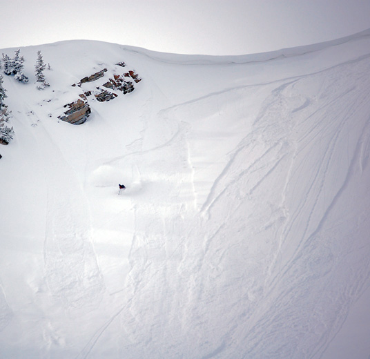
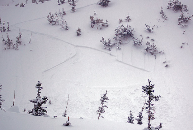
Yesterday, natural
avalanche activity consisted of loose sluffs and a few soft slabs on all
aspects, with the largest slab about 150’ wide. Human triggered activity mirrored the natural
activity – easily
triggered sluffs on slopes of about 40 degrees or steeper, and just a few soft
slabs. Most of these slides were
running within the new snow, but on a few southerly facing slopes that had been
recently scoured by the winds, they were running on the old slick ice
crusts. Most of these new snow
instabilities were strengthening by afternoon, due to warming temperatures and
a bit of sun.
Today, it will still be
possible to trigger a few sluffs and soft slabs in steep terrain, so always be
thinking about the consequences of the terrain you’re in. There is the potential for two factors to
increase the avalanche danger today – wind and sun. If you’re at the higher elevations, the winds
are just strong enough to blow the snow into sensitive drifts that a person
could trigger on a steep slope. The sun will
cause problems today if the clouds thin or skies clear. The surface snow will rapidly heat on steep sunny
slopes, and may heat on low and mid elevation shady slopes with thin cloud
cover. Once the snow heats up, it will
be easy to trigger damp sluffs. And
finally, if you’re traveling in upper elevation, northwest through easterly
facing terrain, be aware there are isolated areas where slide could release on a
deeper weak layer.
Bottom Line:
The avalanche danger is MODERATE today on
slopes steeper than 35 degrees.
Travelers will be able to trigger loose sluffs and soft slabs,
especially on any steep slope with fresh wind drifts, and on steep sunny slopes
if the sun comes out. There will be an
increasing avalanche danger tonight and tomorrow due to strong winds and more
snow in the forecast.
Mountain Weather:
The cold, moist northerly flow over the area will gradually shift to the
southwest tonight. For today, light snow
showers this morning and this afternoon, with periods of clearing and direct
sun possible at times. Highs will be in
the low 20’s at 8,000’ and the mid teens at 10,000’. The northerly winds will generally be in the
10 to 20 mph range, with a period of stronger winds this morning across the
highest peaks. The winds will shift to
the southwest tonight and become strong ahead of the cold front which ishould arrive around noon Thursday. 8 to 12” of snow is possible from this fast
moving storm, and unsettled weather, with periods of snow, is expected through
the weekend.
Announcements:
Here is a great link to a web site on avalanche beacon
information, created by a person who did independent research and testing of
avalanche beacons. http://beaconreviews.com/transceivers/index.htm
There are several free automated avalanche beacon practice areas open, including one at Canyons, one on the by-pass road near Snowbird and one in the northwest corner of the lower lot at Solitude. They are really easy to use, and well worth stopping for a quick practice session.
Early birds and snow
geeks can catch our 6AM report at 364-1591.
Click here to check out our new online avalanche
encyclopedia.
Click HERE for a text only version of the avalanche advisory.
To
have this advisory automatically e-mailed to you each day, click HERE.
UDOT also has a highway avalanche control work
hotline for Big Cottonwood, Little Cottonwood, and
Yesterday,
Wasatch Powderbird Guides flew in
Please
report any backcountry snow and avalanche conditions. Call (801) 524-5304 or 1-800-662-4140, email [email protected] or fax 801-524-6301. The information in this advisory is from the
U.S. Forest Service, which is solely responsible for its content. This advisory describes general avalanche conditions
and local variations always occur.
I will update
this advisory by 7:30 Thursday morning. Thanks for calling.