
In partnership with:
The
Friends of the Utah Avalanche Center Home page is: http://www.utahavalanchecenter.com
To receive automated e-mails
of this advisory click HERE.
Please click here and
fill out our user’s survey
Avalanche advisory
Monday, April 04, 2005
Good morning, this is Brett Kobernik with the
Current Conditions:
Overnight, temperatures did not cool off all that much with most 10,000 foot
stations right around freezing or above.
Winds are currently blowing about like they were during the day
yesterday with ridgetop speeds in the 15 to 25 mph range from the southwest
gusting into the 30s with stiffer gusts near 60 mph at the 11,000 foot
stations.
Avalanche Conditions:
With a good stiff breeze yesterday, I noted that
there was some loose snow blowing off the upper ridges that may have formed
some patchy wind slabs. These won’t pose
much threat today, however.
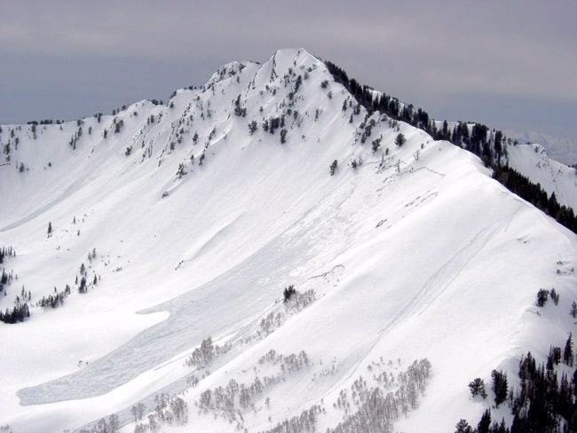
The bigger concern today is
the warm, wet snowpack and what will happen with another foot or better of
fresh snow on top of it. (Wet slab
photo from Saturday) Most mid and
upper elevation slopes will have a crust that formed overnight just from
radiation cooling but with warm temperatures again last night, this crust will
be thin and you will find wet snow underneath in many locations. As you travel today, make sure you are
punching through into the old snow to check crust thickness and to check for
loose, unconsolidated wet snow underneath. Mid and lower elevations along with
southerly aspects at all elevations are more suspect.
As with any new snow event,
you will want to check to see how well the new snow bonds with the current snow
surface. Shovel tilt tests are an
excellent way to check this. (Figure
2.19 & 2.9.8 Shovel Tilt Test)
Quick hand pits and compression tests are also very effective. The winds are forecast to blow 20 to 30 mph
during the storm today so you will need to watch for fresh wind slabs as
well.
Bottom Line (
This
morning the avalanche danger is MODERATE but will be on the rise as the day progresses. Any avalanching involving damp snow is the big
threat today. The storm most likely
won’t put down enough snow until later in the day when the danger could reach CONSIDERABLE.
Danger Scale: http://www.avalanche.org/~uac/ed-scale.htm
Mountain Weather: (You can find the afternoon
Weather Update here.)
The timing of this storm is off for all you powder fiends as snow won’t stack
up significantly until late afternoon then a ridge of high pressure builds in
on Tuesday which will quickly turn any fresh snow to mashed potatoes. Flurries will start this morning with the
main trof moving through around noon when winds will
shift to the northwest and heavier snow will start. Temperatures will drop during the day to
around 20 degrees at 10,000 feet. 12 to
20 inches is possible for today and tonight.
Skies
will clear on Tuesday and 8000 foot temperatures will reach 40.
Yesterday,
the Powderbird guides were grounded due to weather and most likely won’t get
out today.
If you are getting out, we appreciate
your snowpack and avalanche observations.
Please call and leave a message at 524-5304 or 1-800-662-4140, or e-mail
us at [email protected]. Fax is 524-6301.
The information in this
advisory is from the U.S. Forest Service, which is solely responsible for its
content. This advisory describes general avalanche conditions and local
variations always occur.
I will update this advisory by
7:30 on Tuesday morning.
Thanks for calling.