
In partnership with:
The
NEW AND IMPROVED Friends of the Utah Avalanche
Center Home page is: http://www.utahavalanchecenter.com
To receive automated e-mails
of this advisory click HERE.
Avalanche advisory
Thursday, March 24,
2005
Good morning, this is Evelyn Lees with the
In Provo Canyon, the
county road and bikepath are closed from Bridalveil/Nunns
parking lot to Frasier Park due to avalanche danger.
Current Conditions:
A colder, moist west to
northwest flow kept snow falling, with the mountains picking up another 5 to
12” overnight. This brings upper
elevation storm totals since Tuesday afternoon into the 1 ½ to 3 foot range,
with 2 to 3” of water equivalent. The
winds finally decreased, and are now 10 to 15 mph from the west northwest, with
speeds across the highest peaks in the 20 to 30 mph range. Temperatures have cooled into the low 20’s to
upper teens at 10,000’.
Avalanche Conditions:
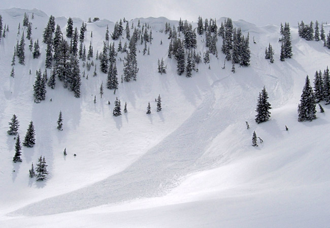
Natural avalanche activity from the backcountry yesterday consisted mostly of
shallow new
snow soft slabs, up to 100’ wide, with wind loaded areas and north through
east facing slopes the most active. Some
slides initiated mid-slope due to wind loading well off the ridges. Ski cuts in the backcountry were easily
releasing similar new snow slides, with results from control work at ski areas
a bit larger, 1 to 3’ deep and up to 400’ wide.
The largest natural reported was
While it’s winter up high,
there are spring conditions at the lower elevations. There were both natural and easily triggered
wet loose sluffs yesterday below about 8,000’ that gouged down and resulted in
impressive debris piles. If the clouds
thin or the sun peeks out today, the snow may rapidly heat on many elevations
and aspects, resulting in more widespread wet avalanche activity. Particularly avoid terrain traps such as
gullies, where the cement like wet snow could pile up deeply.
Bottom Line
(Salt Lake and Park City mountains)
The
avalanche danger is CONSIDERABLE on slopes approaching 35 degrees in steepness
with recent deposits of wind drifted snow, especially those shady slopes facing
northwest through east. Other steep
slopes have a MODERATE
danger. There is a MODERATE
danger of wet loose sluffs below about 8,000’, and on any steep slope receiving
direct sun today the danger may rise to CONSIDERABLE.
Bottom
Line (
The avalanche danger is HIGH
on and below slopes steeper than about 35 degrees. Both human triggered and natural avalanches
are likely. Large natural avalanches
have occurred overnight and this morning.
People without good avalanche and backcountry travel skills should avoid
travel in the
Danger Scale: http://www.avalanche.org/~uac/ed-scale.htm
Mountain Weather: (You can find the afternoon Weather Update here.)
A cold, moist upper level flow will remain over northern
The
Powderbird guides did not get out yesterday, and probably will not get out
today, but if they do will be in
If you are getting out, we
appreciate your snowpack and avalanche observations. Please call and leave a message at 524-5304
or 1-800-662-4140, or e-mail us at [email protected]. Fax is 524-6301.
The information in this
advisory is from the U.S. Forest Service, which is solely responsible for its
content. This advisory describes general avalanche conditions and local
variations always occur.
Thanks for calling.