25th Annual Black Diamond Fall Fundraising Party
Thursday, September 13; 6:00-10:00 PM; Black Diamond Parking Lot
25th Annual Black Diamond Fall Fundraising Party
Thursday, September 13; 6:00-10:00 PM; Black Diamond Parking Lot
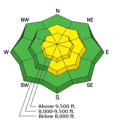
| Advisory: Provo Area Mountains | Issued by Drew Hardesty for Thursday - April 12, 2018 - 6:29am |
|---|

|
bottom line The avalanche danger will rise to MODERATE for new snow instabilities today, particularly with developing wind slabs along the mid and upper elevations. These drifts will be more pronounced on northeast to southeast facing slopes and just to the lee of the ridgelines, and potentially crossloaded beyond the subridges, spines, convexities, and other terrain features. With sustained winds, I expect drifts to become thicker and more widespread over the next 24-36 hours. As an outlier, deeper wet slabs are unlikely but possible in upper elevation terrain as these elevations continue to transition from winter to spring.
|
 |
special announcement The last regular early morning forecast will be Sunday, April 15th. We will issue updates for the Salt Lake zone with every snowfall through the rest of April.
The Wilderness Medicine Program at the University of Utah is surveying the knowledge of both regular and occasional backcountry users. Please provide your input through this survey. https://www.surveymonkey.com/r/AvalancheSafetySkillsSurvey |
 |
current conditions Ahead of the approaching storm, even winds at Arrowhead at the top of Sundance (8250') are gusting into the 60s and 70s from the southwest and overnight "lows" are in the upper 40s to mid-50s. It's just not right. At least the cold front is on the doorstep and I expect to see snow levels dropping to the valley with this event. |
 |
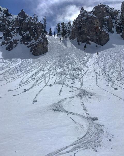
recent activity Ski areas and UDOT noted some natural wet loose activity with the solar gain and daytime highs yesterday. All aspects and elevations reportedly saw some rollerballing and pinwheels, even on the high northerlies. Mark White pic in upper Dry Fork yesterday. No reports from the Provo backcountry yesterday.
|
| type | aspect/elevation | characteristics |
|---|

|
|
LIKELIHOOD
 LIKELY
UNLIKELY
SIZE
 LARGE
SMALL
TREND
 INCREASING DANGER
SAME
DECREASING DANGER
|
|
description
Gusty westerly winds will accompany the at-times heavy snowfall today and continue on into the night as they slowly veer to the northwest. This is not the usual theme as the winds tend to lose steam after the cold front has moved through. It's easy to become complacent with spring storms (especially now because the old deeper slabs are dormant), but spring storms can be highly convective with quite variable conditions from drainage to drainage. Even though I expect the snow to bond fairly well to the old snow surfaces, much depends on the character of the storm. Hot Tip! Instability and avalanche conditions spike during periods of particularly high snowfall rates. Same goes for sustained wind drifting with hourly speeds of roughly 15-30mph. The good news is that the instability should readily show its cards: Test slopes, ski cuts and the usual bag of tricks will reveal much about the snow today. Remember with ski cutting, you're moving diagonally across the slope, crossing to safety, and moving quickly from one area to the next. It can be an effective tool, but dangerous with the wrong conditions, in the wrong terrain, and by inexperienced practitioners. Learn more about wind slabs here. Or check out a nice video by AIARE below. Wind Slab Avalanches from AIARE Avalanche Education on Vimeo. |
 |
weather This should be a fairly prolonged event through tomorrow and many areas favored by a west to northwest flow may see upwards of 6-10" by the time it winds down Friday afternoon. Mountain temperatures will drop to the low teens this afternoon with snowfall dropping to the valleys. Winds will veer to the west and then northwest today, blowing 25-30mph...though increasing to 30-35mph tonight. A weak ridge of high pressure builds in for the weekend with another storm for later Monday and possibly again on Thursday. |
| general announcements CLICK HERE FOR MORE GENERAL INFO AND FAQ The UAC has new support programs with Outdoor Research and Darn Tough. Support the UAC through your daily shopping. When you shop at Smith's, or online at Outdoor Research, REI, Backcountry.com, Darn Tough, Patagonia, NRS, Amazon, eBay a portion of your purchase will be donated to the FUAC. See our Donate Page for more details on how you can support the UAC when you shop. Benefit the Utah Avalanche Center when you buy or sell on eBay - set the Utah Avalanche Center as a favorite non-profit in your eBay account here and click on eBay gives when you buy or sell. You can choose to have your seller fees donated to the UAC, which doesn't cost you a penny This information does not apply to developed ski areas or highways where avalanche control is normally done. This advisory is from the U.S.D.A. Forest Service, which is solely responsible for its content. This advisory describes general avalanche conditions and local variations always occur. |