25th Annual Black Diamond Fall Fundraising Party
Thursday, September 13; 6:00-10:00 PM; Black Diamond Parking Lot
25th Annual Black Diamond Fall Fundraising Party
Thursday, September 13; 6:00-10:00 PM; Black Diamond Parking Lot
| Advisory: Provo Area Mountains | Issued by Mark Staples for Thursday - April 5, 2018 - 5:44am |
|---|


|
bottom line With a deep slab avalanche problem lurking on upper elevation, northerly and easterly facing slopes, the avalanche danger in these locations is MODERATE. Avalanches that occurred last Wednesday show that this deep slab problem is still an issue in the Provo area mountains. These slides can break 2-5 feet deep and up to hundreds of feet wide. All other slopes have a LOW danger. Watch for and avoid any fresh wind drifts and wind slabs. These are much less of a hazard but worth looking for. Hard, icy conditions also exist. While not an avalanche hazard, these "slide for life" conditions add an additional hazard in very steep terrain.
|
 |
special announcement The UAC Marketplace is still open. Our online marketplace still has deals on skis, packs, airbag packs, beacons, snowshoes, soft goods and much more. |
 |
current conditions Mountain temperatures this morning above 8000 feet are in the mid 30's F with westerly winds averging 10 mph gusting to 15 mph. The snowpack is mostly hard and frozen. |
 |
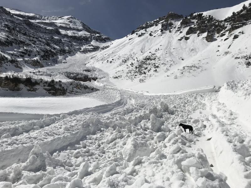
recent activity No avalanche activity was reported yesterday. There was an impressive avalanche cycle that occurred last week on Timpanogos. The snowpack in the Provo area mountains is very different and more dangerous that in the mountains just a little further north. Read the full observation HERE. Below is a list of some of these slides and a photo (J. Woodruff) of the debris pile from one of them.
|
| type | aspect/elevation | characteristics |
|---|

|

|
LIKELIHOOD
 LIKELY
UNLIKELY
SIZE
 LARGE
SMALL
TREND
 INCREASING DANGER
SAME
DECREASING DANGER
|
|
description
The snowpack in the Provo area mountains is generally more dangerous than other areas further north. This area received less snowfall in the early months of winter, making it more shallow and weaker. Unfortunately many of those weak, faceted layers of snow remain at the upper elevation, northerly facing slopes. All it took to cause last week's avalanche cycle was strong winds. There are two layers of concern in the snowpack:
It's best to avoid any and all steep northerly facing terrain. If going to ski some of the Peaks in the Provo area, it will be best to ski slopes that face a little more southerly. Go to these slopes after a few melt/freeze cycles and hopefully enjoy some stable corn skiing. In the near term |
| type | aspect/elevation | characteristics |
|---|

|
|
LIKELIHOOD
 LIKELY
UNLIKELY
SIZE
 LARGE
SMALL
TREND
INCREASING DANGER
SAME
DECREASING DANGER
|
|
description
The snowpack has a hard frozen surface. A few inches of snow plus strong winds Monday night created isolated wind drifts and wind slabs. Watch out for "slide for life" conditions in steep terrain where the hard icy snow means you may not be able to stop if you fall. Cloud cover today should limit warming and softening of the snowpack. |
 |
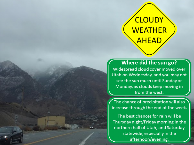
weather Today will be similar to yesterday with mostly cloudy skies that will limit much warming. High temperatures at 9000 feet should reach the mid 30's F or slightly warmer. Winds will remain light averging about 10 mph. Moisture will arrive tonight with a disturbance that will bring and inch or two of snow above 9000 feet and rain below that elevation. Cloudy skies will remain over the area Friday. A warm storm will arrive on Saturday. The rain/snow line will again be around 9000 feet and winds should increase. Above that elevation 3-6 inches of snow should fall. Sunday will have cooler temperatures and lingering snow showers.
|
| general announcements CLICK HERE FOR MORE GENERAL INFO AND FAQ The UAC has new support programs with Outdoor Research and Darn Tough. Support the UAC through your daily shopping. When you shop at Smith's, or online at Outdoor Research, REI, Backcountry.com, Darn Tough, Patagonia, NRS, Amazon, eBay a portion of your purchase will be donated to the FUAC. See our Donate Page for more details on how you can support the UAC when you shop. Benefit the Utah Avalanche Center when you buy or sell on eBay - set the Utah Avalanche Center as a favorite non-profit in your eBay account here and click on eBay gives when you buy or sell. You can choose to have your seller fees donated to the UAC, which doesn't cost you a penny This information does not apply to developed ski areas or highways where avalanche control is normally done. This advisory is from the U.S.D.A. Forest Service, which is solely responsible for its content. This advisory describes general avalanche conditions and local variations always occur. |