25th Annual Black Diamond Fall Fundraising Party
Thursday, September 13; 6:00-10:00 PM; Black Diamond Parking Lot
25th Annual Black Diamond Fall Fundraising Party
Thursday, September 13; 6:00-10:00 PM; Black Diamond Parking Lot
| Advisory: Provo Area Mountains | Issued by Evelyn Lees for Sunday - March 25, 2018 - 7:07am |
|---|

|
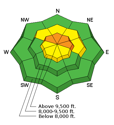
bottom line The avalanche danger is CONSIDERABLE at the upper elevations of the Provo area mountains. There remains an isolated chance of triggering a Deep Slab avalanche 2 to 5 feet deep on northerly through easterly facing slopes at the upper elevations. Slopes that are rocky or have a shallower snowpack are most suspect, especially in terrain that has slid one or more times this year. As we know so little about the upper elevation snow pack, a conservative attitude is necessary. Wind Slabs can be triggered on steep slopes at the upper elevations, most widespread on northerly facing slopes.
|
 |
special announcement The UAC Marketplace is still open. Our online marketplace still has deals on skis, packs, airbag packs, beacons, snowshoes, soft goods and much more. |
 |
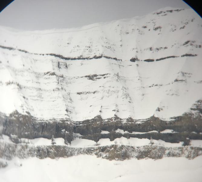
current conditions Skies are cloudy this morning, and temperatures are in the low to upper 30s at the low to mid elevations in the Provo area mountains. Upper elevations are probably in the twenties and teens. Southerly winds are blustery – averaging 10 to 15 mph at mid elevations, gusting in the 30s. Speeds across the upper elevation ridge lines to the north average 25 to 35 mph, with gusts to 50 mph. The Thursday/Friday drenching fast-forwarded our snowpack to mid April – melted out trailheads some more and created isothermal snow at low to mid elevations, which is strong when frozen, weak when wet. The hard icy snow will not soften much for the next few days, so again, think spring - sharpen your edges, consider ice axes, crampons, whippets or ski crampons, depending on your project – “slide for life’s” are a real concern. Low snow at the Timp Divide snowtel site and at 9,000'. Drew Hardesty photos.
|
 |
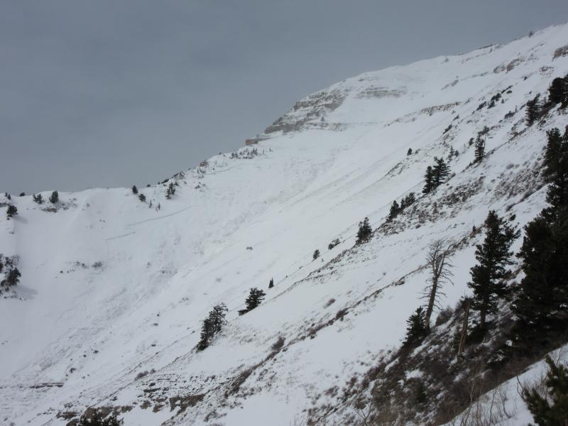
recent activity A large avalanches was intentionally triggered yesterday morning by UDOT in Provo Canyon in the Slide Canyon drainage. It started at 10,400 feet as a dry slab avalanche and ran nearly 4000 feet vertical becoming wet as it descended. Recent Provo observations: 03/24/2018 Observation: UFO Bowls Provo region Hardesty, Wilson 03/23/2018 Avalanche: Slide Canyon Provo region Woody 03/22/2018 Avalanche: Cascade Cirque Provo region Woody Slide Canyon Avalanche, Woody
|
| type | aspect/elevation | characteristics |
|---|

|

|
LIKELIHOOD
 LIKELY
UNLIKELY
SIZE
 LARGE
SMALL
TREND
 INCREASING DANGER
SAME
DECREASING DANGER
|
|
description
The persistent southerly winds continued to drift snow all night, mostly at the higher elevations onto northerly facing slopes. These sensitive wind slabs will be found mostly along ridge lines, but watch for some drifting on mid elevation slopes and drifts cross-loaded along gully walls and onto other aspects by the swirling winds. |
| type | aspect/elevation | characteristics |
|---|

|
|
LIKELIHOOD
LIKELY
UNLIKELY
SIZE
 LARGE
SMALL
TREND
INCREASING DANGER
SAME
DECREASING DANGER
|
|
description
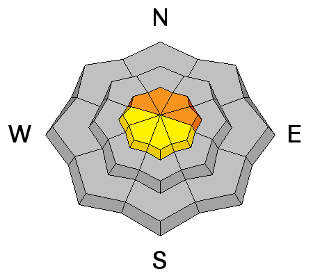
Above 9500 feet, the snowpack is dry, especially on northerly aspects, and a deep persistent slab avalanche problem exists in these areas. The recent storm with 1.6 inches of water is a major load that is stressing faceted layers near the ground and in the middle of the snowpack near a dust layer. The snowpack in the Provo area mountains is much weaker than it is just a little further north. Yesterday's avalanche triggered by UDOT is a red flag that more will occur today. Wind slab? Deep slab? Drew Hardesty photo of natural avalanche with wide propagation below Cascade Cirque ridgeline
|
 |
weather The cold front entering northwest Utah this morning will bring increasing clouds with light snow starting late this afternoon in the Provo area mountains. Snow totals today through Monday morning should add up to 2 to 5”. Temperatures today will remain in the low to upper 30s, and then cool into the teens tonight. The brisk, southerly winds (averaging 15 to 25 mph at the mid elevations, 25 to 35 mph at the upper elevations) will gradually decrease through out the day, and drop even more after they shift to the northwest tonight. A few lingering snow showers on Monday, and much colder. |
| general announcements CLICK HERE FOR MORE GENERAL INFO AND FAQ The UAC has new support programs with Outdoor Research and Darn Tough. Support the UAC through your daily shopping. When you shop at Smith's, or online at Outdoor Research, REI, Backcountry.com, Darn Tough, Patagonia, NRS, Amazon, eBay a portion of your purchase will be donated to the FUAC. See our Donate Page for more details on how you can support the UAC when you shop. Benefit the Utah Avalanche Center when you buy or sell on eBay - set the Utah Avalanche Center as a favorite non-profit in your eBay account here and click on eBay gives when you buy or sell. You can choose to have your seller fees donated to the UAC, which doesn't cost you a penny This information does not apply to developed ski areas or highways where avalanche control is normally done. This advisory is from the U.S.D.A. Forest Service, which is solely responsible for its content. This advisory describes general avalanche conditions and local variations always occur. |