25th Annual Black Diamond Fall Fundraising Party
Thursday, September 13; 6:00-10:00 PM; Black Diamond Parking Lot
25th Annual Black Diamond Fall Fundraising Party
Thursday, September 13; 6:00-10:00 PM; Black Diamond Parking Lot
| Advisory: Provo Area Mountains | Issued by Evelyn Lees for Sunday - March 11, 2018 - 7:06am |
|---|

|
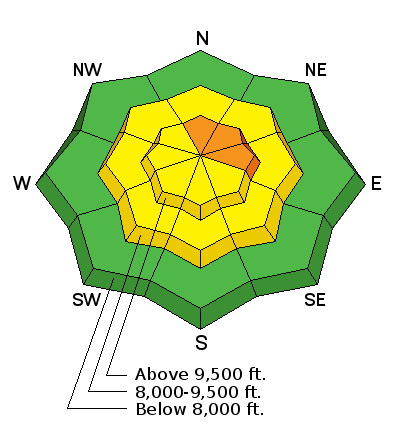
bottom line Areas of CONSIDERABLE hazard exists for triggering a persistent slab avalanche on slopes facing west to north through southeast at the mid and upper elevations. These slides may be triggered remotely, and may break out several hundred feet wide. Warming temperatures today will also lead to a period of wet loose activity on solar aspects, as well as all around the compass at lower elevations. SAFER riding conditions can be found on low angle northerly terrain with no overhead hazard. ROOF-ALANCHES are likely and have resulted in fatalities in years past.
|
 |
special announcement The UAC Marketplace is still open. Our online marketplace still has deals on skis, packs, airbag packs, beacons, snowshoes, soft goods and much more. Episode 6 of the UAC podcast "A Conversation with Tom Kimbrough, Hemingway of the Wasatch" is live. We explore ideas about lifetime exposure to risk and what role Buddhism has played in his life as a climber, skier, and soon-to-be octogenarian. We talk about what has changed over the years in snow science and the role of mentorship in the world of avalanche forecasting and other professions and pursuits. Check it out on ITunes, Stitcher, the UAC blog.
|
 |
current conditions Under mostly clear skies, there should have been a descent refreeze overnight at the mid and upper elevations. Temperatures are in the upper 20s to low 30s at the low to mid elevations. Winds are blowing about 10 to 15 mph averages, with the general flow in northern Utah from the southeast. A bit of soft dense remains on northerly facing slopes above about 9,000’, all other slopes are sporting frozen crusts this morning, many breakable, that should soften with daytime heating. The snow is melting off fast at the lower elevations and on sunny slopes. |
 |
recent activity Warming temperatures this past week led to a significant avalanche cycle in the Provo mountains over the past several days.
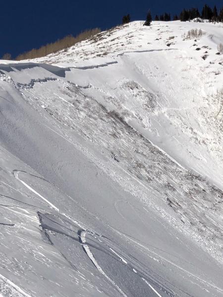
If you are heading north, another deep, dangerous slab avalanche was triggered yesterday by a snowmobiler – with a good outcome as no one was caught. First Cornice is on the Midway side of Guardsman Pass. Preliminary information is here. March 10th First Cornice avalanche, Photos by Colby Zimmerman
|
| type | aspect/elevation | characteristics |
|---|

|

|
LIKELIHOOD
 LIKELY
UNLIKELY
SIZE
 LARGE
SMALL
TREND
 INCREASING DANGER
SAME
DECREASING DANGER
|
|
description
The weak layers faceted layers that formed this winter fromed in November through February remain widespread in the Provo area mountains, and the Provo area mountains have some of the shallowest and weakest snow in northern Utah. Some of the steep slopes are just waiting for a trigger – and which slopes will slide are variable and unpredictable, but steep mid and upper elevations slopes facing northwest thorough southeasterly are the bulls eye terrain. Especially avoid steep, complex terrain with break overs, shallow rocky spots with a thin snowpack and cliffs and be aware of changes in aspect. |
| type | aspect/elevation | characteristics |
|---|

|
|
LIKELIHOOD
 LIKELY
UNLIKELY
SIZE
 LARGE
SMALL
TREND
 INCREASING DANGER
SAME
DECREASING DANGER
|
|
description
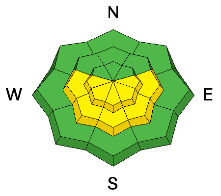
Wet Loose: As the temperatures warm into the 40s and 50s today, the snow will once again become wet and sloppy on most aspects and elevations. The increasing clouds should help prevent natural wet snow slides, but rider triggered wet loose sluffs will be possible on all aspects and elevations except the high northerly facing slopes. Roof-avalanches: Buildings are starting to shed their winter snow, so look up and avoid travel below steep roofs. Dave Richards photo:
Cornices often break back further than expected, on to what looks like flat terrain. So give them a wide berth and avoid travel below th |
 |
weather A small storm system crossing southern Utah today is sending clouds our way. Skies should become mostly cloudy today in the Provo area mountains and the southeasterly winds remain light, with speeds in the 5 to 15 mph range. Today’s high temperatures will be in the upper 30s to low 50s. The warming trend will continue into Wednesday, with a chance for mountain snow and cooler temperatures late in the week. |
| general announcements CLICK HERE FOR MORE GENERAL INFO AND FAQ The UAC has new support programs with Outdoor Research and Darn Tough. Support the UAC through your daily shopping. When you shop at Smith's, or online at Outdoor Research, REI, Backcountry.com, Darn Tough, Patagonia, NRS, Amazon, eBay a portion of your purchase will be donated to the FUAC. See our Donate Page for more details on how you can support the UAC when you shop. Benefit the Utah Avalanche Center when you buy or sell on eBay - set the Utah Avalanche Center as a favorite non-profit in your eBay account here and click on eBay gives when you buy or sell. You can choose to have your seller fees donated to the UAC, which doesn't cost you a penny This information does not apply to developed ski areas or highways where avalanche control is normally done. This advisory is from the U.S.D.A. Forest Service, which is solely responsible for its content. This advisory describes general avalanche conditions and local variations always occur. |


 We Need Your Help With Social Media