25th Annual Black Diamond Fall Fundraising Party
Thursday, September 13; 6:00-10:00 PM; Black Diamond Parking Lot
25th Annual Black Diamond Fall Fundraising Party
Thursday, September 13; 6:00-10:00 PM; Black Diamond Parking Lot
| Advisory: Provo Area Mountains | Issued by Greg Gagne for Friday - March 9, 2018 - 7:26am |
|---|


|
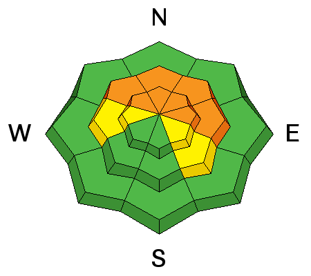
bottom line Areas of CONSIDERABLE hazard exists for triggering a persistent slab avalanche on slopes facing west to north through southeast at the mid and upper elevations. These slides may be triggered remotely, and may break out several hundred feet wide. A MODERATE hazard exists as warming temperatures today will also lead to a period of wet loose activity on solar aspects, as well as all around the compass at lower elevations. SAFER riding conditions can be found on low angle northerly terrain with no overhead hazard. ROOF-ALANCHES are likely and have resulted in fatalities in years past.
|
 |
special announcement We have discount lift tickets for Alta, Snowbird, Brighton, Solitude, Snowbasin,and Beaver Mountain. Details and order information here. All proceeds from these go towards paying for avalanche forecasting and education. Saturday March 10 Be prepared if going snowshoeing - Snowshoe Backcountry 101 Introduction to Avalanches at Brighton Resort. Two snowshoers were killed in an avalanche in Washington just over a week ago. Get educated or recommend this class to a friend.
|
 |
current conditions Skies are partly cloudy with mountain temps throughout the 30s F. Winds are generally light and from the southwest. Snow depths are 30-45" in the mid-elevations of the Provo mountains and riding conditions are good on upper elevation slopes facing due north. Other aspects will be crusted. |
 |
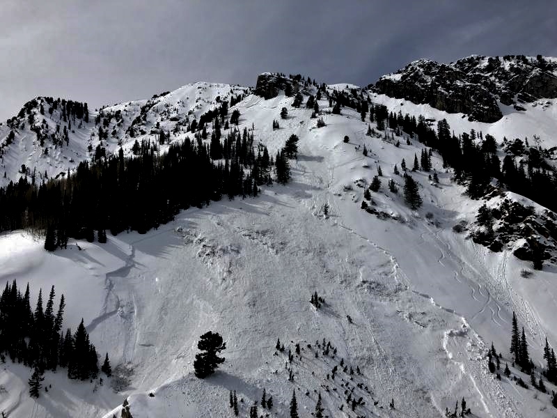
recent activity Warming temperatures this past week led to a significant avalanche cycle in the Provo mountains over the past several days.
This is in addition to a large natural out of the NE Chute of Elk Point that had been previously reported. Elk Point is a sub-peak of Timpanogos, looming large above Aspen Grove (up the street from Sundance). It likely ran over 3000' and left a sizeable debris pile (pc: Warnick). Elk Point has some of the more interesting avalanche paths on Timpanogos and the NE Chute was the site of the tragic triple fatality the day after Christmas 2003. (Disregard the slope and aspect on the app below. The starting zone was probably 10,600' on a very steep east to northeast face.)
|
| type | aspect/elevation | characteristics |
|---|

|
|
LIKELIHOOD
 LIKELY
UNLIKELY
SIZE
 LARGE
SMALL
TREND
 INCREASING DANGER
SAME
DECREASING DANGER
|
|
description
The snowpack in the Provo Mountains (essentially everything on the south side of the Little Cottonwood/American Fork ridgeline down toward the Skyline) has a more, shall we say, tender snowpack. Larger naturals occurred with last weekend's storm and significant avalanches have run naturally and with human weight over the last several days. A bit further to the north, a large skier-triggered slide on an east aspect at 9700' on Kessler Peak in Big Cottonwood Canyon. The rider was carried 300' and fortunately emerged with no serious injuries.
Mark Staples and Trent Meisenheimer went to the scene late yesterday afternoon and have an excellent accident write-up as well as video summary (pay particular attention to Mark's sage advice towards the end of the video, advice that can be applied to many of the mountain locations in Utah): If you choose to ride in this terrain, you have to do your work and break out your shovel and dig down to evaluate the strength of these faceted layers, all the while keeping in mind that this weakness may be different elsewhere on the slope. (For example, notice the tracks on the slope adjacent to yesterday's Kessler slide.) Be sure to consider the consequences of getting caught in one of these slides. Don't roll the dice as the house usually wins. How can this persistent slab hazard be handled? Terrain is your friend: enjoy the powder on low angle slopes with no overhead hazard. |
| type | aspect/elevation | characteristics |
|---|

|

|
LIKELIHOOD
LIKELY
UNLIKELY
SIZE
 LARGE
SMALL
TREND
 INCREASING DANGER
SAME
DECREASING DANGER
|
|
description
With warm temperatures expected today, expect continued wet-loose snow activity as the sun warms the snow surface. Cloud cover may also lead to afternoon greenhousing where low and mid elevation northerly aspects become wet. Fortunately wet activity has been held somewhat in check this week with cooperating periods of wind, clouds, and cooler temperatures, helping the solar aspects gradually adjust to warming from the sun. If you see signs of rollerballs and sloppy snow above the boot-tops, it's time to move to a shadier aspect. As we have seen with the Elk Point natural, some of these slides are running far down into the valleys, close to trails popular with hikers and snowshoers. KEY POINT: ROOF-A-LANCHES will be a significant concern. Watch for many houses to shed their winter coats with the sun and daytime heating. Fatalities have occurred due to this very real hazard. |
 |
weather Partly cloudy skies and warm temperatures rising into the 40’s. Winds will be westerly, and generally light, gusting into the teens at mid elevations and 20’s at upper elevations. We may get a few snowflakes overnight into Saturday morning. Afterwards, a somber period of ridging through at least mid-week, with a hint of optimism for better* weather late this coming week. (* stormier) |
| general announcements CLICK HERE FOR MORE GENERAL INFO AND FAQ The UAC has new support programs with Outdoor Research and Darn Tough. Support the UAC through your daily shopping. When you shop at Smith's, or online at Outdoor Research, REI, Backcountry.com, Darn Tough, Patagonia, NRS, Amazon, eBay a portion of your purchase will be donated to the FUAC. See our Donate Page for more details on how you can support the UAC when you shop. Benefit the Utah Avalanche Center when you buy or sell on eBay - set the Utah Avalanche Center as a favorite non-profit in your eBay account here and click on eBay gives when you buy or sell. You can choose to have your seller fees donated to the UAC, which doesn't cost you a penny This information does not apply to developed ski areas or highways where avalanche control is normally done. This advisory is from the U.S.D.A. Forest Service, which is solely responsible for its content. This advisory describes general avalanche conditions and local variations always occur. |


 We Need Your Help With Social Media