25th Annual Black Diamond Fall Fundraising Party
Thursday, September 13; 6:00-10:00 PM; Black Diamond Parking Lot
25th Annual Black Diamond Fall Fundraising Party
Thursday, September 13; 6:00-10:00 PM; Black Diamond Parking Lot
| Advisory: Provo Area Mountains | Issued by Trent Meisenheimer for Monday - February 26, 2018 - 7:12am |
|---|

|
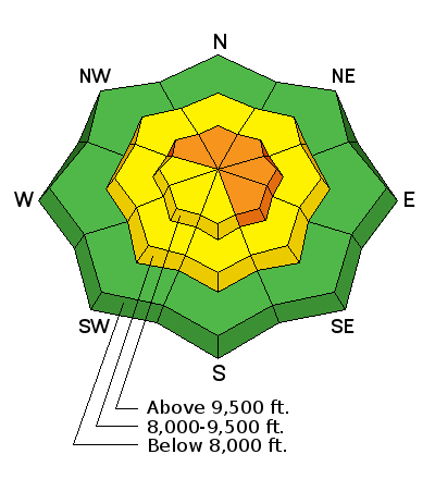
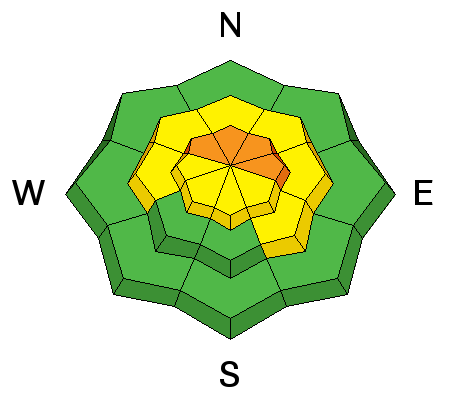
bottom line The avalanche danger is CONSIDERABLE on all steep, upper elevation slopes facing northwest through southeast, especially those with recent wind drifts. Other steep slopes have a MODERATE danger. Complex and dangerous avalanche conditions exist – cautious route finding, careful snow pack evaluation and conservative decision making essential.
|
 |
special announcement We have discount lift tickets for Alta, Snowbird, Brighton, Solitude, Snowbasin, and Beaver Mountain. Details and order information here. All proceeds from these go towards paying for avalanche forecasting and education! |
 |
current conditions Under mostly cloudy skies the southerly winds are beginning to increase as the next system to our west dives south off the coast of California. Current wind speeds vary with elevation.
Temperatures remain on the cold side this morning with ridge tops in the teens °F - trail heads are in the upper teens to low twenties °F. The riding conditions remain excellent with blower powder in the north facing sheltered slopes. Southerly facing slopes were kissed by the sun yesterday afternoon and will have a thin, zipper crust in places. |
 |
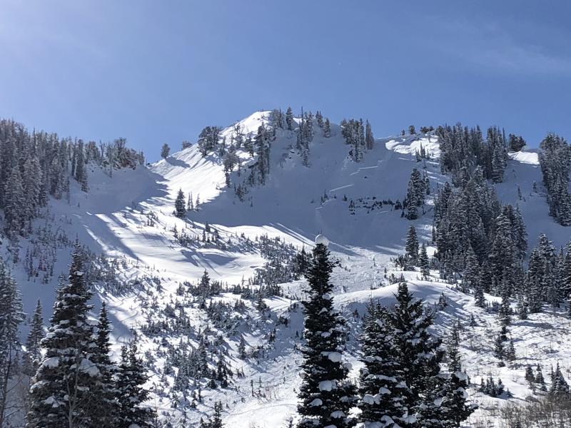
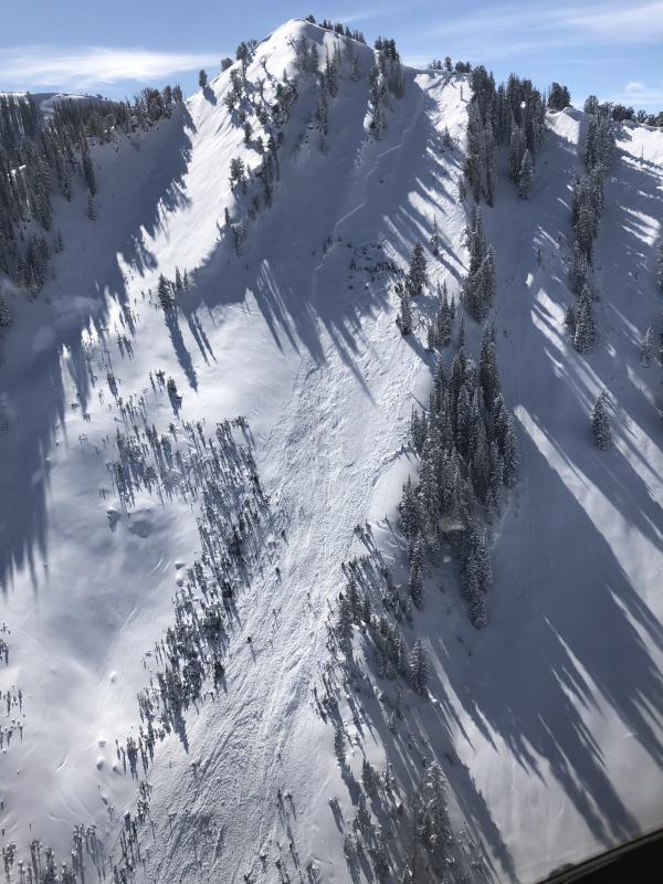
recent activity The most significant avalanche reported yesterday was in American Fork Canyon. This was a natural avalanche that failed in old, weak, faceted snow and was large enough to break trees, and could bury, injure, or kill a person. Over the weekend, 5 huge collapses were reported on low angle terrain on Provo peak, by a party that went to 9500’. In the in an area where 2/3’s of the snow pack is old faceted snow. Provo area observations: 02/24/2018 Avalanche: Provo Peak Provo region Andrew Bentz 02/24/2018 Observation: Mary Ellen Salt Lake region L. Dunn 02/22/2018 Observation: Bobs Knob Provo region Woody 02/21/2018 Avalanche: Provo Provo region Andrew Bentz Photo: Logan Cookler, slab avalanche, American Fork Canyon, Fat Franks.
|
| type | aspect/elevation | characteristics |
|---|

|

|
LIKELIHOOD
 LIKELY
UNLIKELY
SIZE
 LARGE
SMALL
TREND
 INCREASING DANGER
SAME
DECREASING DANGER
|
|
description
It's all about how much snow is available for transport - over the past week, upper elevation terrain received 15-30'' inches of new snow. As the southerly winds increase today - so will the danger. It will be most pronounced on upper elevation northwest through southeast facing slopes. Look for and avoid, rounded, smooth pillows of snow. Cracking of denser snow is sometimes an indication that you have hit a wind slab. Cornices have continued to grow along the mid and upper elevation ridge lines. They often break back further than expected, so give them a wide berth and avoid travel below them. |
| type | aspect/elevation | characteristics |
|---|

|
|
LIKELIHOOD
 LIKELY
UNLIKELY
SIZE
 LARGE
SMALL
TREND
INCREASING DANGER
SAME
DECREASING DANGER
|
|
description
At what point do we start tipping the scales and our avalanche problem comes to life? this is a good question. Maybe, it's today with stronger south winds. Our snowpack is plagued with faceted snow that varies with aspect and elevation. The biggest eye opener for me was seeing yesterday's natural avalanche in American Fork. This is very representative of shallow snowpack zones and an indicator that some slopes are just waiting for a trigger. Avoid, shallow, rocky, wind loaded terrain, where the snowpack is thinner and more suspect. If you trigger a persistent slab avalanche it will likely be unsurvivable. My strategy remains the same and I continue to avoid the bigger and more committing terrain - I just don't trust a faceted snowpack. I am leaving myself plenty of outs if the snowpack doesn't agree with my decision. Photo: Logan Cookler, natural avalanche in Fat Franks, American Fork Canyon.
|
 |
weather Increasing clouds and southerly winds will be on tap today as a storm dives south over California. Unfortunately, this system will not deliver the snow like we were expecting a couple of days ago. For today, we will see on and off again snow showers and in places we could end up with 2-5" of new snow. Mountain temperatures will climb into the mid to upper twenties °F. Winds will remain out of the south, blowing 15-25 mph gusting into the 30's at ridge tops. We will be under a warming trend for the next few days with a larger and more organized storm shaping up for the weekend. |
| general announcements CLICK HERE FOR MORE GENERAL INFO AND FAQ The UAC has new support programs with Outdoor Research and Darn Tough. Support the UAC through your daily shopping. When you shop at Smith's, or online at Outdoor Research, REI, Backcountry.com, Darn Tough, Patagonia, NRS, Amazon, eBay a portion of your purchase will be donated to the FUAC. See our Donate Page for more details on how you can support the UAC when you shop. Benefit the Utah Avalanche Center when you buy or sell on eBay - set the Utah Avalanche Center as a favorite non-profit in your eBay account here and click on eBay gives when you buy or sell. You can choose to have your seller fees donated to the UAC, which doesn't cost you a penny This information does not apply to developed ski areas or highways where avalanche control is normally done. This advisory is from the U.S.D.A. Forest Service, which is solely responsible for its content. This advisory describes general avalanche conditions and local variations always occur. |