25th Annual Black Diamond Fall Fundraising Party
Thursday, September 13; 6:00-10:00 PM; Black Diamond Parking Lot
25th Annual Black Diamond Fall Fundraising Party
Thursday, September 13; 6:00-10:00 PM; Black Diamond Parking Lot
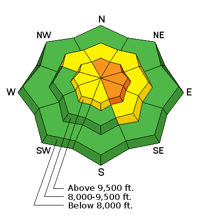
| Advisory: Provo Area Mountains | Issued by Evelyn Lees for Saturday - February 17, 2018 - 7:41am |
|---|

|
bottom line The avalanche danger is CONSIDERABLE on steep, upper elevation north through easterly facing slopes with recent deposits of wind-drifted snow. A triggered wind drift may step down to a deeper weak layer, resulting in a large, dangerous avalanche. Most other steep mid and upper elevation terrain has a MODERATE avalanche danger. Low angle, wind sheltered, shady slopes will have the best powder snow with less avalanche risk. Sunday and Monday - a winter storm with strong winds and heavy snowfall will increase the avalanche danger in all the mountains of northern and central Utah. Local avalanche forecasts are updated every morning.
|
 |
special announcement We are saddened to report that Orem resident Alexander Marra was killed in an avalanche today, Saturday, February 10, in Wyoming. He was skiing out-of-bounds at JHMR, and triggered a 2-foot deep slide that took him over cliffs. Our thoughts and sympathies go out to his family and friends. Accident Report. Episode 5 of the UAC podcast "To Hell in a Heartbeat - A Conversation With Tom Diegel and Matt Clevenger About the 12.26.08 Full Burial on Little Water" is live. Matt and Tom about the avalanche documented in To Hell in a Heartbeat. Check it out on ITunes, Stitcher, the UAC blog. |
 |
current conditions After 48 hours of well-behaved winds, speeds kicked up last night, especially at the upper elevations. At times, the southwesterly winds have averaged 25 to 30 mph at the mid elevations in the Provo area mountains, with gusts in the 40s. The upper elevations are where the real action is – just to the north, 35 to 45 mph averages, gusting to 60 mph. Mountain temperatures range from the teens to the low twenties. |
 |
recent activity Thanks to an observation from Woody: Two slides observed in Cascade Cirque on apron below main head wall. The larger one is on an ENE face at 10300' and appears to be 600' wide by 12" deep. The second is on a NE shoulder at 10000' and appears to be roughly 200' wide by 12" deep. Can't tell if they are hard slabs or soft slabs. Best guess is that they ran naturally yesterday mid-day sometime. 11000' ridge tops had significant wind transport onto the E-NE faces today. (Looked like snow guns were set up and blowing along the ridge line of Timp today It's been very active to the north in the Salt Lake and Park City area mountains: With better visibility, we have more information on avalanches from both Thursday and Friday: 02/16/2018 Salt Lake region: Avalanche: West Monitor, Snowboarder trigger - 2' deep - 350' wide 02/16/2018 Salt Lake region: Avalanche: Little Superior, Skier trigger - 14" deep - 40' wide 02/15/2018 Salt Lake region: Avalanche: Cardiff Fork, Natural trigger - 40' wide 02/15/2018 Salt Lake region: Avalanche: Emma Ridges, Skier trigger - 18" deep - 20' wide 02/15/2018 Salt Lake region: Avalanche: Reynolds East Face, Skier trigger - 3' deep - 50' wide 02/15/2018 Salt Lake region: Avalanche: Catchers Mit, Skier trigger - 2' deep - 100' wide 02/15/2018 Salt Lake region: Avalanche: Pointy Peak, Natural trigger - 2' deep - 100' wide 02/15/2018 Salt Lake region: Avalanche: Airplane Peak, Natural trigger - 3.5' deep - 100' wide 02/15/2018 Salt Lake region: Avalanche: Hogum Hogback, Natural trigger - 2' deep - 70' wide |
| type | aspect/elevation | characteristics |
|---|

|

|
LIKELIHOOD
 LIKELY
UNLIKELY
SIZE
 LARGE
SMALL
TREND
 INCREASING DANGER
SAME
DECREASING DANGER
|
|
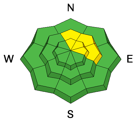
description
Today’s stronger winds have lots of snow to drift and blow around. Wind drifts, known as wind slabs, often look smooth and rounded, and when you find one, they can be cracky, denser and deeper than the surrounding snow. As the winds are getting well down into the mid elevations, look for drifts along both mid and upper elevation ridge lines and cross-loaded along gully walls, mid slope break overs and sub ridges. Avoid any wind drifts on steep slopes. The winds are significantly stronger at the upper elevations, so be aware of steep wind drifted slopes above – natural avalanches are possible. |
| type | aspect/elevation | characteristics |
|---|

|
|
LIKELIHOOD
 LIKELY
UNLIKELY
SIZE
 LARGE
SMALL
TREND
INCREASING DANGER
SAME
DECREASING DANGER
|
|
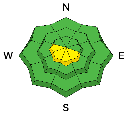
description
The weight of Thursday’s snow was enough to make the buried faceted weak layers reactive once again on a few slopes. Today’s westerly winds will be adding more snow and weight onto slopes with buried facets – especially upper elevation slopes facing northerly through easterly, making them easier to trigger. A wind slab avalanche could trigger a deeper slide, failing on one of these faceted weak layers. There is a lot of variability in the snowpack strength and depth, with facet layers both mid pack and near the ground. Slopes with a shallower snowpack tend to have weaker snow – including slopes that have slid one or more times this year. Cracking and collapsing are bulls-eye clues to instability. |
| type | aspect/elevation | characteristics |
|---|

|
|
LIKELIHOOD
 LIKELY
UNLIKELY
SIZE
LARGE
SMALL
TREND
INCREASING DANGER
SAME
DECREASING DANGER
|
|
description
Even with the cooling breeze, sun and warm temperatures may heat the snow on steeper southeast through westerly facing slopes today. Human triggered and natural wet loose sluffs will become possible as the snow becomes damp and wet, possibly running longer than expected on the slick crusts beneath. Roller balls are often the first sign on heating snow. |
 |
weather It will be warm and windy today, with temperatures nearing 30 at 10,000’ and 40 to 45 at 8,500’. Winds will increase with elevation – 20 to 30 mph averages at 9 to 10,000’, with gusts in the 40s. The highest peaks will average to 40 mph, with gusts in the 60s. It will be very windy tonight and Sunday ahead of a strong cold front that should reach northern Utah late Sunday afternoon, bringing periods of snow through at least Monday night. 12 to 24” are possible. |
| general announcements CLICK HERE FOR MORE GENERAL INFO AND FAQ The UAC has new support programs with Outdoor Research and Darn Tough. Support the UAC through your daily shopping. When you shop at Smith's, or online at Outdoor Research, REI, Backcountry.com, Darn Tough, Patagonia, NRS, Amazon, eBay a portion of your purchase will be donated to the FUAC. See our Donate Page for more details on how you can support the UAC when you shop. Benefit the Utah Avalanche Center when you buy or sell on eBay - set the Utah Avalanche Center as a favorite non-profit in your eBay account here and click on eBay gives when you buy or sell. You can choose to have your seller fees donated to the UAC, which doesn't cost you a penny This information does not apply to developed ski areas or highways where avalanche control is normally done. This advisory is from the U.S.D.A. Forest Service, which is solely responsible for its content. This advisory describes general avalanche conditions and local variations always occur. |


