25th Annual Black Diamond Fall Fundraising Party
Thursday, September 13; 6:00-10:00 PM; Black Diamond Parking Lot
25th Annual Black Diamond Fall Fundraising Party
Thursday, September 13; 6:00-10:00 PM; Black Diamond Parking Lot
| Advisory: Provo Area Mountains | Issued by Drew Hardesty for Saturday - January 13, 2018 - 7:48am |
|---|


|
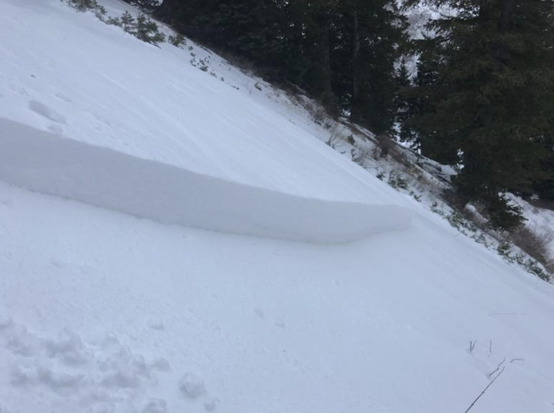
bottom line Areas of CONSIDERABLE danger exist mainly in the mid to upper elevation northerly through easterly aspects. Human triggered sides may be up to 1-2' deep and may be triggered from below.
|
 |
special avalanche bulletin THE FOREST SERVICE UTAH AVALANCHE CENTER IN SALT LAKE CITY HAS ISSUED A BACKCOUNTRY AVALANCHE SPECIAL BULLETIN. * TIMING…IN EFFECT FROM 9 PM MST FRIDAY TO 9 PM MST MONDAY * AFFECTED AREA…FOR THE MOUNTAINS OF NORTHERN UTAH INCLUDING THE WASATCH RANGE...BEAR RIVER RANGE...UINTA MOUNTAINS. * AVALANCHE DANGER…DANGEROUS HUMAN TRIGGERED AVALANCHES REMAIN LIKELY. * IMPACTS…BEAUTIFUL WEATHER OVER THE HOLIDAY WEEKEND AND RECENT FRESH POWDER SNOW WILL LEAD TO A SIGNIFICANT INCREASE IN PUBLIC USE IN THE MOUNTAINS OF NORTHERN UTAH. SNOWPACK, WEATHER, AND HUMAN CONDITIONS ARE PERFECTLY ALIGNED FOR A POTENTIAL ACCIDENT THIS WEEKEND. MANY SLOPES, ESPECIALLY ONES ABOVE 8000 FT WITH A NORTHERLY THROUGH EASTERLY ASPECT, ONLY NEED A SKIER OR RIDER TO TRIGGER AN AVALANCHE 2-3 FEET DEEP AND SEVERAL HUNDRED FEET WIDE. THIS WARNING DOES NOT APPLY TO SKI AREAS WHERE AVALANCHE HAZARD REDUCTION MEASURES ARE PERFORMED. |
 |
special announcement Episode 2 of the UAC podcast has been released. Check it out on ITunes, Stitcher, the UAC blog, or wherever you get your podcasts. |
 |
current conditions Any cloud cover should burn off soon. Winds are westerly, blowing 10-15mph. Temps are in the upper 20s. Snow depths sit at 1-2'. |
 |
recent activity One observer in the Provo area mountains on Thursday reported triggering a small test slope at 7900' in elevation 12" deep by 100' wide.
Mark Staples visited Provo area Thursdayt and was able to spot some natural avalanche activity with his binoculars. Observation found HERE. |
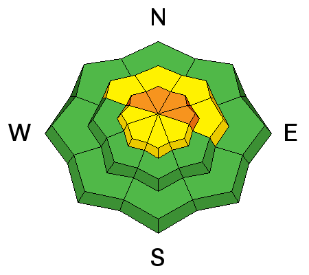
| type | aspect/elevation | characteristics |
|---|

|
|
LIKELIHOOD
 LIKELY
UNLIKELY
SIZE
 LARGE
SMALL
TREND
 INCREASING DANGER
SAME
DECREASING DANGER
|
|
description
A poor snowpack structure exists at the mid and upper elevations and most pronounced on the northerly through easterly aspects. Cracking, collapsing, snow tests and recent avalanching offer testimony to areas of unstable snow. Careful snowpack evaluation and cautious route-finding is required. |
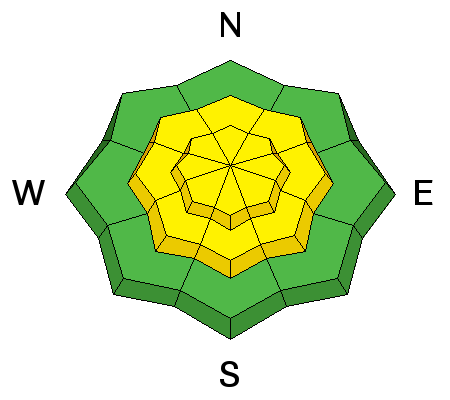
| type | aspect/elevation | characteristics |
|---|

|
|
LIKELIHOOD
 LIKELY
UNLIKELY
SIZE
 LARGE
SMALL
TREND
 INCREASING DANGER
SAME
DECREASING DANGER
|
|
description
Uncertainty of conditions in the Provo mountains results in conservative ratings here; we might expect lingering wind drifts in the open exposed terrain. |
 |
weather Any cloudy cover should start to burn off soon. We'll have winds out of the northwest, blowing 10-15mph. Ridgetop temps will rise toward the upper 20s. High pressure builds in over the next several days with a couple storms on the horizon - one for mid-week and another for the weekend. More info on our Mountain Weather page, updated by noon. |
| general announcements CLICK HERE FOR MORE GENERAL INFO AND FAQ Support the UAC through your daily shopping. When you shop at Smith's, or online at REI, Backcountry.com, Patagonia, NRS, Amazon, eBay a portion of your purchase will be donated to the FUAC. See our Donate Page for more details on how you can support the UAC when you shop. Benefit the Utah Avalanche Center when you buy or sell on eBay - set the Utah Avalanche Center as a favorite non-profit in your eBay account here and click on eBay gives when you buy or sell. You can choose to have your seller fees donated to the UAC, which doesn't cost you a penny. This information does not apply to developed ski areas or highways where avalanche control is normally done. This advisory is from the U.S.D.A. Forest Service, which is solely responsible for its content. This advisory describes general avalanche conditions and local variations always occur. |