25th Annual Black Diamond Fall Fundraising Party
Thursday, September 13; 6:00-10:00 PM; Black Diamond Parking Lot
25th Annual Black Diamond Fall Fundraising Party
Thursday, September 13; 6:00-10:00 PM; Black Diamond Parking Lot
| Advisory: Provo Area Mountains | Issued by Drew Hardesty for Wednesday - December 27, 2017 - 7:43am |
|---|

|
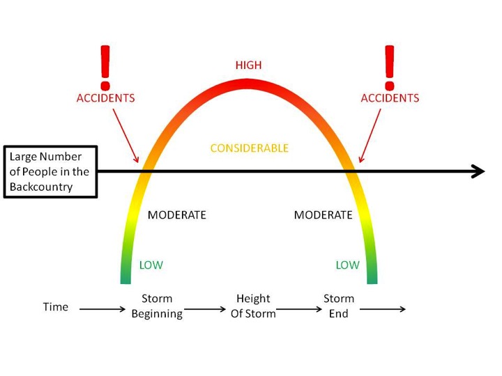
bottom line We have a solid CONSIDERABLE avalanche danger on many slopes in the backcountry. Remember that these 1-2' deep and up to 300' wide avalanches are unmanageable - they can be triggered remotely from a distance and from below. Best to choose low angle slopes not connected to steeper terrain above. I'll be honest here: these are the types of days where we see avalanche accidents.
|
 |
special announcement Do you have all the gear you need? Check out the UAC’s online marketplace and auction for deals on resort passes, skis, packs, airbag packs, beacons, snowshoes, soft goods and much more. The auction closes at 6PM on December 28. |
 |
current conditions We have clear skies with gusty southwest winds blowing 20-25mph. Temps are in the upper 20s to low 30s. Low elevation snow totals are thin still with probably closer to 1 1/2 feet up high. |
 |
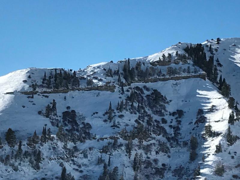
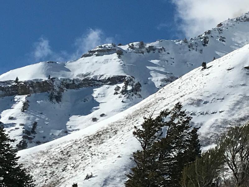
recent activity Photos below of natural activity in steep shady terrain on Timpanogos from a couple days ago. (UDOT Provo Canyon)
|
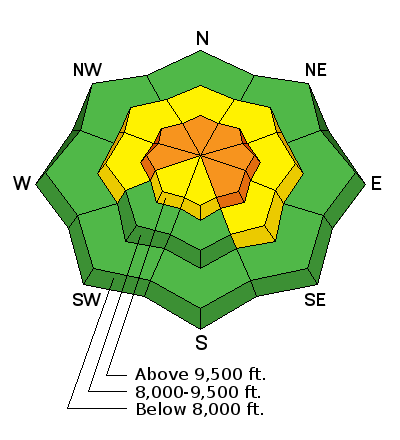
| type | aspect/elevation | characteristics |
|---|

|
|
LIKELIHOOD
 LIKELY
UNLIKELY
SIZE
 LARGE
SMALL
TREND
 INCREASING DANGER
SAME
DECREASING DANGER
|
|
description
Collapsing, cracking and avalanches. These are the bulls eye clues to watch for in the upper elevations of the Provo area mountains. These weak faceted layers will be very slow to stabilize, and avoidance is key. The facets are most widespread on northwest through easterly facing slopes at the upper elevations. So avoid travel on and below all steep slopes, including even the smaller, steep gullies, creek beds and road banks at the mid elevations. Collapsing of the weak snowpack noted at 7700' on a north facing slope yesterday. The weak faceted snow is evident in the photo below from UDOT Provo Canyon.
|
| type | aspect/elevation | characteristics |
|---|

|

|
LIKELIHOOD
LIKELY
UNLIKELY
SIZE
LARGE
SMALL
TREND
 INCREASING DANGER
SAME
DECREASING DANGER
|
|
description
Increasing winds will create unstable wind slabs in the more exposed terrain and more prominent on northeast to east to southeast facing slopes or at the mid-elevations where wind swirl the snow onto unusual aspects. Note that triggered wind slabs my step down into older faceted snow, creating a larger avalanche. |
 |
weather We'll see increasing clouds with a disturbance passing by to the north. Westerly winds will increase to 30mph along the high ridglines. Mountain temps will be in the upper 20s to low 30s. Another weak brush by moves through early Friday with another weak system for the weekend. |
| general announcements FOR MORE GENERAL INFORMATION AND FAQ, CLICK HERE Support the UAC through your daily shopping. When you shop at Smith's, or online at REI, Backcountry.com, Patagonia, NRS, Amazon, eBay a portion of your purchase will be donated to the FUAC. See our Donate Page for more details on how you can support the UAC when you shop. Benefit the Utah Avalanche Center when you buy or sell on eBay - set the Utah Avalanche Center as a favorite non-profit in your eBay account here and click on eBay gives when you buy or sell. You can choose to have your seller fees donated to the UAC, which doesn't cost you a penny This information does not apply to developed ski areas or highways where avalanche control is normally done. This advisory is from the U.S.D.A. Forest Service, which is solely responsible for its content. This advisory describes general avalanche conditions and local variations always occur. |