25th Annual Black Diamond Fall Fundraising Party
Thursday, September 13; 6:00-10:00 PM; Black Diamond Parking Lot
25th Annual Black Diamond Fall Fundraising Party
Thursday, September 13; 6:00-10:00 PM; Black Diamond Parking Lot
| Advisory: Provo Area Mountains | Issued by Mark Staples for Saturday - December 23, 2017 - 7:36am |
|---|

|
bottom line Today the avalanche danger is MODERATE at the upper elevations with a few inches of new snow and westerly winds that are creating fresh wind slabs. The biggest danger is hitting rocks whether by getting caught in an avalanche or not.
|
 |
special announcement TONIGHT at Brighton in partnership with the Brighton Ski Patrol, we'll be giving a free avalanche awareness presentation focusing on why shallow snowpack winters, just like this year, are so dangerous. The talk begins a 5 p.m. in the Alpine Rose building on the 3rd floor. Do you have all the gear you need? Check out the UAC’s online marketplace and auction for deals on resort passes, skis, packs, airbag packs, beacons, snowshoes, soft goods and much more. The auction closes at 6PM on December 28. |
 |
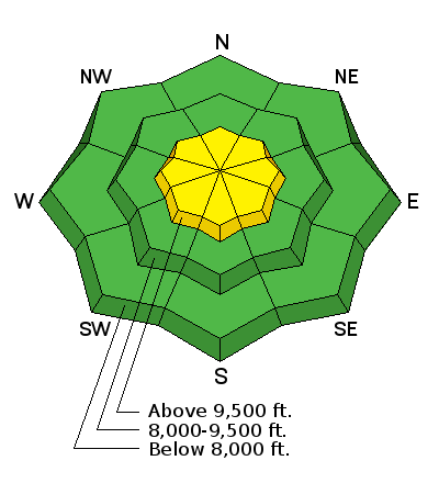
current conditions As of 6 a.m. 3 inches of snow had fallen with more coming. Temperatures were in the low to mid 20s F. Winds at ridge tops were averaging 10-20 mph from the W with gusts of 40 mph. The snowpack in the Provo area mountains remains very thin and most slopes below 9500 feet were bare ground early this week. This storm won't be enough snow to change that situation and ice climbing and hiking may be the current activities of choice in this area. Week in Review > Saturday Dec 16 the Wasatch mountains picked up a trace to 2" of very low-density snow. > Quiet weather Sunday through Tuesday. > Strong south and southwest winds on Wednesday ushered in a cold front that arrived late Wednesday afternoon. Storm totals by Thursday included:
|
 |
recent activity No recent avalanches have been reported in the Provo area mountains. |
| type | aspect/elevation | characteristics |
|---|

|
|
LIKELIHOOD
 LIKELY
UNLIKELY
SIZE
 LARGE
SMALL
TREND
 INCREASING DANGER
SAME
DECREASING DANGER
|
|
description
With a few inche of new snow and winds strong enough to transport it, there are shallow wind slabs that can be triggered today. Simply look for and avoid fresh deposits of wind transported snow. |
| type | aspect/elevation | characteristics |
|---|

|
|
LIKELIHOOD
 LIKELY
UNLIKELY
SIZE
LARGE
SMALL
TREND
 INCREASING DANGER
SAME
DECREASING DANGER
|
|
description
Old snow that became weak and faceted exist at the highest elevations on northerly facing slopes. This storm isn't enough to cause avalanches on this old snow, but it is capping it and just beginning to form a slab that may grow large enough in the future to cause avalanches. |
 |
weather Snowfall will continue into this afternoon until a NW flow shuts off snowfall. Depending on the timing of the NW winds, an additional 3-6 inches of snow should fall. Temperatures may only warm a few degrees into the upper 20s F. Winds should continue blowing 10-20 mph from the SW with 30-40 mph gusts and may ease some when they shift to the NW. |
| general announcements FOR MORE GENERAL INFORMATION AND FAQ, CLICK HERE Support the UAC through your daily shopping. When you shop at Smith's, or online at REI, Backcountry.com, Patagonia, NRS, Amazon, eBay a portion of your purchase will be donated to the FUAC. See our Donate Page for more details on how you can support the UAC when you shop. Benefit the Utah Avalanche Center when you buy or sell on eBay - set the Utah Avalanche Center as a favorite non-profit in your eBay account here and click on eBay gives when you buy or sell. You can choose to have your seller fees donated to the UAC, which doesn't cost you a penny This information does not apply to developed ski areas or highways where avalanche control is normally done. This advisory is from the U.S.D.A. Forest Service, which is solely responsible for its content. This advisory describes general avalanche conditions and local variations always occur. |


