25th Annual Black Diamond Fall Fundraising Party
Thursday, September 13; 6:00-10:00 PM; Black Diamond Parking Lot
25th Annual Black Diamond Fall Fundraising Party
Thursday, September 13; 6:00-10:00 PM; Black Diamond Parking Lot
| Advisory: Provo Area Mountains | Issued by Mark Staples for Saturday - April 8, 2017 - 6:55am |
|---|

|
bottom line Generally safe avalanche conditions exist and the danger is LOW. Watch for loose wet snow avalanches if any significant rain falls, and watch for fresh wind slabs later today. Otherwise, get ready for great powder tomorrow if the weather forecast holds true.
|
 |
special announcement Golf to benefit the Utah Avalanche Center? We have a donated gift certificate for four guest rounds and cart fees at Jeremy Ranch. We are asking $500 for this unique experience to golf for avalanche safety. See the certificate for conditions. Contact us if you are interested. |
 |
current conditions This morning it's warm and windy and raining hard at the SLC airport at 5:30 a.m. The freezing line is at 10,000 ft, and temperatures are in the mid to upper 40's F at trail heads. At ridgetops winds are averaging 30-50 mph and gusting to 80 mph from the south. Most of the precipitation this morning is falling near the Idaho/Utah border. Riding conditions will be drastically different between this morning and tomorrow morning. Read more in the weather section at the bottom. For a recap of this week's weather go HERE. |
 |
recent activity No avalanches have been reported. |
| type | aspect/elevation | characteristics |
|---|

|
|
LIKELIHOOD
 LIKELY
UNLIKELY
SIZE
 LARGE
SMALL
TREND
 INCREASING DANGER
SAME
DECREASING DANGER
|
|
description
With warm temperatures and rain, loose wet snow avalanches can occur today. Watch for this problem in places that receive rain this morning. |
| type | aspect/elevation | characteristics |
|---|

|

|
LIKELIHOOD
LIKELY
UNLIKELY
SIZE
LARGE
SMALL
TREND
INCREASING DANGER
SAME
DECREASING DANGER
|
|
description
Strong winds this morning have very little snow available to transport and form wind slabs. However, some snow should fall today and allow winds to form fresh wind slabs later today. New snow and wind-blown snow will land on a variety of surfaces including:
Pay attention to how the new snow is bonding (or not bonding) to these various surfaces. It should bond quickly to wet snow and more slowly to the others. Graupel may fall during frontal passage and form a temporary weak layer that limits bonding as well. Watch Greg's short video about some weak snow on high elevation north aspects. |
| type | aspect/elevation | characteristics |
|---|

|
|
LIKELIHOOD
 LIKELY
UNLIKELY
SIZE
 LARGE
SMALL
TREND
 INCREASING DANGER
SAME
DECREASING DANGER
|
|
description
Cornices are huge now. Cold air arriving tonight should decrease the chances of natural cornice fall. Regardless, they are unpredictable. Avoid being under or on top of them. They can break further back you would expect. If you have to travel under them, move quickly and limit your exposure. |
 |
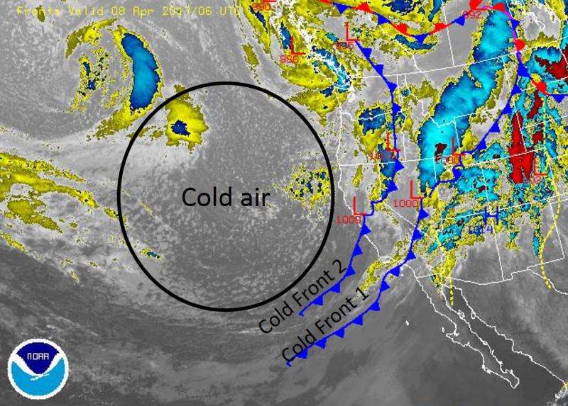
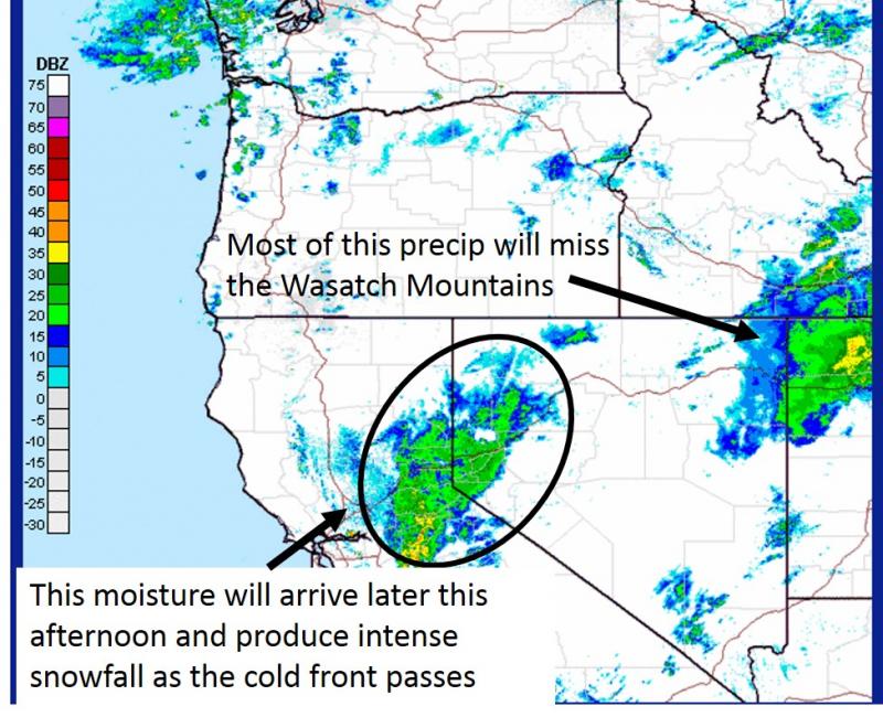
weather A band of moisture is crossing the northernmost part of Utah this morning with the first cold front. This moisture should break up and not produce any significant precipitation. Strong south winds will blow 20-30 mph and gust 50-60 mph at ridgetops with 90 mph gust possible at the highest elevations. No accumulating precipitation should fall today. A second cold front will arrive around 5 p.m. and bring a drastic drop in temperatures, a short period of intense snowfall, possible lightning/thunder, and more strong winds. The freezing line will drop to 6000 feet followed by a moist northwest flow that produces more snow. By tomorrow morning, there should be about 6 inches of new snow.
The Provo area mountains will be on the southern boundary of this moisture and receive less snow than areas further north.
|
| general announcements Remember your information can save lives. If you see anything we should know about, please help us out by submitting snow and avalanche conditions. You can also call us at 801-524-5304, email by clicking HERE, or include #utavy in your tweet or Instagram. To get help in an emergency (to request a rescue) in the Wasatch, call 911. Be prepared to give your GPS coordinates or the run name. Dispatchers have a copy of the Wasatch Backcountry Ski map. Backcountry Emergencies. It outlines your step-by-step method in the event of a winter backcountry incident. If you trigger an avalanche in the backcountry, but no one is hurt and you do not need assistance, please notify the nearest ski area dispatch to avoid a needless response by rescue teams. Thanks.
EMAIL ADVISORY If you would like to get the daily advisory by email you will need to subscribe here. DAWN PATROL Hotline updated daily by 5-530am - 888-999-4019 option 8. TWITTER Updates for your mobile phone - DETAILS UDOT canyon closures: LINK TO UDOT, or on Twitter, follow @UDOTavy, @CanyonAlerts or @AltaCentral Utah Avalanche Center mobile app - Get your advisory on your iPhone along with great navigation and rescue tools. Powderbird Helicopter Skiing - Blog/itinerary for the day Lost or Found something in the backcountry? - http://nolofo.com/ To those skinning uphill at resorts: it is critical to know the resort policy on uphill travel. You can see the uphill travel policy for each resort here. Benefit the Utah Avalanche Center when you shop from Backcountry.com or REI: Click this link for Backcountry.com or this link to REI, shop, and they will donate a percent of your purchase price to the UAC. Both offer free shipping (with some conditions) so this costs you nothing! Benefit the Utah Avalanche Center when you buy or sell on ebay - set the Utah Avalanche Center as a favorite non-profit in your ebay account here and click on ebay gives when you buy or sell. You can choose to have your seller fees donated to the UAC, which doesn't cost you a penny. This information does not apply to developed ski areas or highways where avalanche control is normally done. This advisory is from the U.S.D.A. Forest Service, which is solely responsible for its content. This advisory describes general avalanche conditions and local variations always occur |