25th Annual Black Diamond Fall Fundraising Party
Thursday, September 13; 6:00-10:00 PM; Black Diamond Parking Lot
25th Annual Black Diamond Fall Fundraising Party
Thursday, September 13; 6:00-10:00 PM; Black Diamond Parking Lot
| Advisory: Provo Area Mountains | Issued by Evelyn Lees for Thursday - March 23, 2017 - 7:09am |
|---|

|
bottom line The avalanche danger is MODERATE today for triggering wet loose sluffs on steep slopes of all aspects and elevations. Slides triggered in the newest snow will turn into wet sluffs as they travel downhill. Gullies and couloirs of all aspects have the potential to produce the largest avalanches and debris piles, and should be avoided today. Lower angle slopes at the upper elevations should have great turning and riding conditions in the new dense soft snow.
|
 |
special announcement “I try to do the right thing at the right time. They may just be little things, but usually they make the difference between winning and losing.” - Kareem Abdul Jabbar Be sure to check out the last installment of the The Little Things - habits that might keep you alive, a four part series of tricks and tidbits to help keep you on top picked up by one of our observers during years of mostly incident-free wandering in the backcountry by ski, foot, and boat. |
 |
current conditions It’s raining hard in the valley, but it’s a welcome return to winter in the mountains with light to moderate snow falling. Temperatures have finally cooled into the 20s at the mid and upper elevations, and the rain/snow line dropped to below 6,500’. So far, snow numbers of the creamy, dense, track filling snow aren’t too impressive, but more is on the way… Storm totals, with water amounts from both rain and snow; yesterday’s rain/snow line as high as 9500’:
Winds in the Provo area mountains have been a bit stronger than most areas - from the southwest, averaging 20 to 25 mph, with gusts in the 30s at times. |
 |
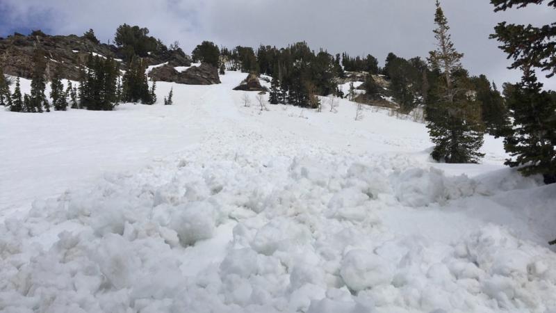
recent activity Very small wet, loose sluffs were easily triggered in yesterday’s few inches of damp snow, including a small natural wet loose sluff. On Tuesday, with explosives, a Cottonwood resort released a wet sluff that broke to the ground, on a northeast-facing slope at 10,000’, over 2 feet deep. Andy Nassetta photo, natural wet loose sluff of the newest snow, from Grizzly Gulch yesterday.
|
| type | aspect/elevation | characteristics |
|---|

|

|
LIKELIHOOD
 LIKELY
UNLIKELY
SIZE
 LARGE
SMALL
TREND
 INCREASING DANGER
SAME
DECREASING DANGER
|
|
description
Wet snow is spooky and unpredictable. There has been no meaningful refreeze of the snowpack for over a week, and while the air temperatures are dropping, the old snow will take time to cool. It’s still warm and wet, especially as many locations had rain to 9,500’ yesterday. Wet loose sluffs can be triggered today on steep slopes of all aspects and elevations. Expect most new snow avalanches triggered in the dry new snow at the higher elevations to turn into wet loose sluffs as they move downhill. Slides today have the potential to create sizable debris piles of heavy, dense snow. Best bet is to enjoy the new soft snow on lower angle slopes today, and use small test slopes to determine how easily the new snow sluffs before getting on steeper slopes. |
| type | aspect/elevation | characteristics |
|---|

|

|
LIKELIHOOD
LIKELY
UNLIKELY
SIZE
LARGE
SMALL
TREND
INCREASING DANGER
SAME
DECREASING DANGER
|
|
description
The winds have been from the southwest, and are forecast to shift to the northwest this afternoon and increase. Sensitive drifts will build through out the day at the higher elevations. |
| type | aspect/elevation | characteristics |
|---|

|
|
LIKELIHOOD
 LIKELY
UNLIKELY
SIZE
 LARGE
SMALL
TREND
 INCREASING DANGER
SAME
DECREASING DANGER
|
|
description
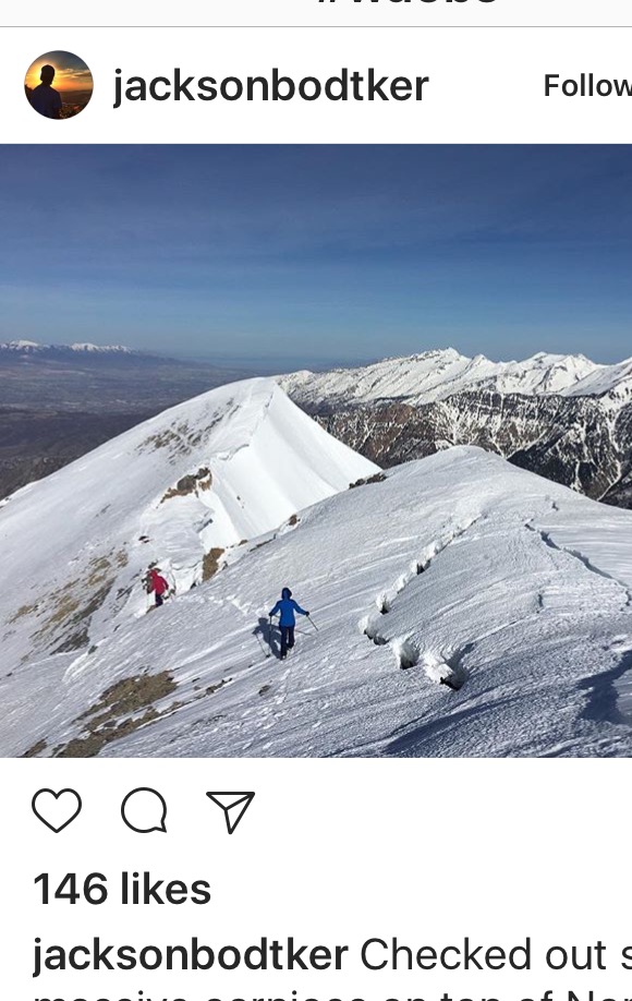
Glide cracks have opened through out the range, from Ogden south through Provo. They are most common where there are smooth rock slabs or grass beneath the snow. Try to avoid travel below these cracks, and stay out of their run out zones. Common locations include Broads Fork, Stairs Gulch and Mill B South in Big Cottonwood Canyon, and Raymond Slabs. Cornices: Below is a Jackson Bodtker photo from Timpanogos a few days ago. Note the cracks of a failing cornice - they will be hidden beneath the new snow today, and harder to identify. Avoidance is key – don’t travel beneath cornices and stay well back from the edges. Cornices tend to break well back onto what looks like flat terrain.
|
 |
weather The storm slowly moving east has the potential to drop an additional 4 to 8 inches of snow today, with snow densities decreasing as temperatures drop throughout the day. This morning’s very light and variable winds will become steady from the northwest this afternoon and increase. By evening, average speeds of 20 mph, with gusts to 25 are possible, with the highest peaks averaging 30 mph. Cloudy and cool tonight, with temperatures in the 20s. After a break on Friday, another storm is on deck for Saturday. |
general announcements
|