25th Annual Black Diamond Fall Fundraising Party
Thursday, September 13; 6:00-10:00 PM; Black Diamond Parking Lot
25th Annual Black Diamond Fall Fundraising Party
Thursday, September 13; 6:00-10:00 PM; Black Diamond Parking Lot
| Advisory: Provo Area Mountains | Issued by Evelyn Lees for Saturday - March 18, 2017 - 7:20am |
|---|

|
bottom line START and FINISH EARLY TODAY – consider BEING OUT OF THE BACKCOUNTRY BEFORE NOON. The avalanche danger will rapidly rise to MODERATE this morning - wet loose sluffs are possible on steep slopes of almost all aspects and elevations. Once the snow becomes wet, sloppy or unsupportable where you are, head for low angle terrain and avoid travel beneath steep slopes. In isolated places, natural avalanches are possible today. Avoid travel below the huge sagging cornices and opening glide cracks
|
 |
special announcement Spring Special: We have a few donated Snowbird, Snowbasin, Solitude, and Brighton discount lift tickets left and have just lowered the price. Ski a day and benefit the Utah Avalanche Center! Order here. Little things can make a big difference if caught in an avalanche. Read all three installments from guest blogger Tom Diegel. Part 1, Part 2, Part 3 |
 |
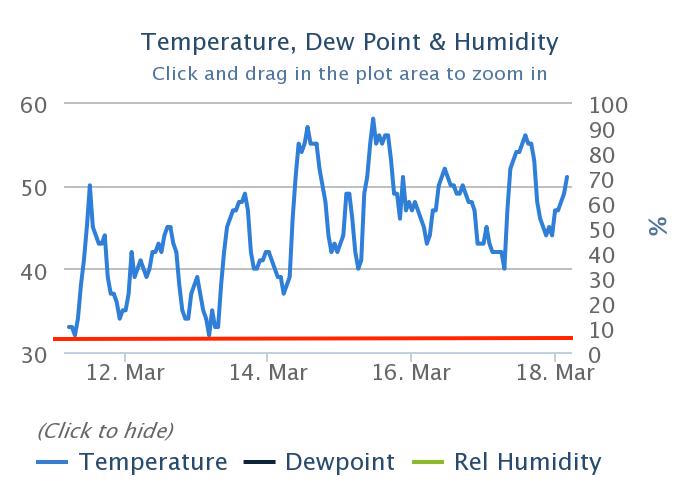
current conditions Under mostly clear skies, temperatures below freezing just aren’t happening this morning. There are a few 30’s to be found in the canyon bottoms and on the 11,000’ peaks, but in the 8 to 10,000’ elevation band, temperatures are in the upper 40s to low 50s . The southerly winds are increasing, averaging 15 mph, with gusts 25. to the north, the high peaks are averaging 25 mph, and gusting in the 40s. Any frozen crusts at the low elevations will be short lived, rapidly softening. At the upper elevations, winds may keep the snow frozen longer and surfaces hard and icy. Depending on your timing and terrain, ice axes, crampons, whippets and/or ski crampons could prevent a “slide for life”. 7-day temperature graphs for Timp Divide Snotel (8140') Red line in 32 degrees.
|
 |
recent activity No avalanche activity was reported yesterday. |
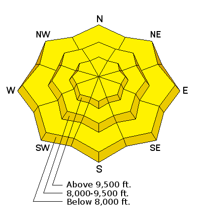
| type | aspect/elevation | characteristics |
|---|

|
|
LIKELIHOOD
 LIKELY
UNLIKELY
SIZE
 LARGE
SMALL
TREND
 INCREASING DANGER
SAME
DECREASING DANGER
|
|
description
Just when you thought it couldn’t get any hotter…along comes a record-breaking day. The snow will rapidly soften today and become wet and sloppy. Wet loose sluffs can be triggered today on all aspects and elevations except the highest, northerly facing slopes. I’m counting on todays’ wind and occasional clouds to help cool the snow. But be alert to the heating snow where you are in the backcountry – wet, punchy, sloppy snow means it’s time to head out of the backcountry, or at least to stay on lower angle slopes and avoid run-out zones of steeper avalanche paths. Natural avalanches may be possible today. |
| type | aspect/elevation | characteristics |
|---|

|
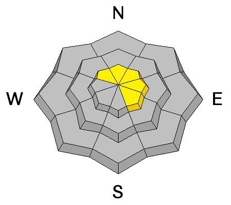
|
LIKELIHOOD
LIKELY
UNLIKELY
SIZE
 LARGE
SMALL
TREND
INCREASING DANGER
SAME
DECREASING DANGER
|
|
description
Enormous cornices still dot the ridge lines, drooping in the heat. Avoidance is the key - stay way back from the edges of the cornices (they always break back further than expected) and minimize any time spent beneath. |
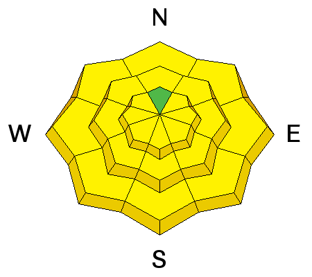
| type | aspect/elevation | characteristics |
|---|
|
|
LIKELIHOOD
 LIKELY
UNLIKELY
SIZE
LARGE
SMALL
TREND
 INCREASING DANGER
SAME
DECREASING DANGER
|
|
description
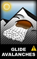
Glide cracks are opening through out the range, and occur primarily where there are smooth rock slabs beneath the snow. |
 |
weather Skies will be mostly clear this morning, but high thin clouds are sneaking over the border, which will bring varying cirrus this afternoon. Temperatures will soar into the mid 60s at 8,000’ and remain in the low 40s at 10,000’. The southwesterly winds will average 10 to 15 mph. For peaks favored by the southerly flow, averages of 35 mph with gusts to 55 mph, will occur. A dry cold front tonight will bring some relief, with temperatures finally dropping below freezing. After a brief warm up on Monday, temperatures will be on a downward slide this week, with chances of several small shots of snow mid week into next weekend. |
| general announcements Remember your information can save lives. If you see anything we should know about, please help us out by submitting snow and avalanche conditions. You can also call us at 801-524-5304, email by clicking HERE, or include #utavy in your tweet or Instagram. To get help in an emergency (to request a rescue) in the Wasatch, call 911. Be prepared to give your GPS coordinates or the run name. Dispatchers have a copy of the Wasatch Backcountry Ski map. Backcountry Emergencies. It outlines your step-by-step method in the event of a winter backcountry incident. If you trigger an avalanche in the backcountry, but no one is hurt and you do not need assistance, please notify the nearest ski area dispatch to avoid a needless response by rescue teams. Thanks.
EMAIL ADVISORY If you would like to get the daily advisory by email you will need to subscribe here. DAWN PATROL Hotline updated daily by 5-530am - 888-999-4019 option 8. TWITTER Updates for your mobile phone - DETAILS UDOT canyon closures: LINK TO UDOT, or on Twitter, follow @UDOTavy, @CanyonAlerts or @AltaCentral Utah Avalanche Center mobile app - Get your advisory on your iPhone along with great navigation and rescue tools. Powderbird Helicopter Skiing - Blog/itinerary for the day Lost or Found something in the backcountry? - http://nolofo.com/ To those skinning uphill at resorts: it is critical to know the resort policy on uphill travel. You can see the uphill travel policy for each resort here. Benefit the Utah Avalanche Center when you shop from Backcountry.com or REI: Click this link for Backcountry.com or this link to REI, shop, and they will donate a percent of your purchase price to the UAC. Both offer free shipping (with some conditions) so this costs you nothing! Benefit the Utah Avalanche Center when you buy or sell on ebay - set the Utah Avalanche Center as a favorite non-profit in your ebay account here and click on ebay gives when you buy or sell. You can choose to have your seller fees donated to the UAC, which doesn't cost you a penny. This information does not apply to developed ski areas or highways where avalanche control is normally done. This advisory is from the U.S.D.A. Forest Service, which is solely responsible for its content. This advisory describes general avalanche conditions and local variations always occur. |