25th Annual Black Diamond Fall Fundraising Party
Thursday, September 13; 6:00-10:00 PM; Black Diamond Parking Lot
25th Annual Black Diamond Fall Fundraising Party
Thursday, September 13; 6:00-10:00 PM; Black Diamond Parking Lot
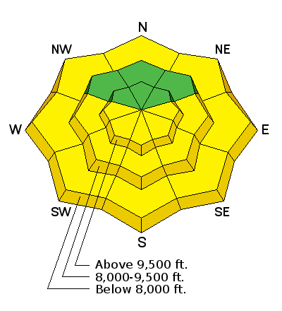
| Advisory: Provo Area Mountains | Issued by Greg Gagne for Friday - March 17, 2017 - 7:06am |
|---|

|
bottom line Mostly Low hazard early this morning will quickly rise to a Moderate risk of loose, wet avalanches with warm temperatures and strong sunshine. There also is a Moderate risk of both human-triggered - as well as natural - cornice falls. Notoriously unpredictable glide avalanches are also possible in localized terrain.
|
 |
special announcement
|
 |
current conditions Skies are clear and mountain temperatures this morning are in the low 40's F. in the Provo mountains. Winds are light and out of the west, gusting to less than 10 mph. Very few observations from Thursday, although we received an excellent observation from the Provo mountains from Joey Dempster. For those who enjoy non-fiction horror, the week in review appears below, and more details can be found here. Week in Review: The most dominant ridging pattern of the otherwise excellent 2016/17 winter season has placed a stranglehold on the Wasatch. High and low temperatures observed this week at Alta guard station at 8800' in Little Cottonwood Canyon: Saturday 3/11 46/28 As can be seen, it has been several days without below freezing temperatures. Other stations recorded much higher maximum and minimum temperatures throughout this period, reaching the upper 50's at many mountain locations, with overnight lows only dropping into the upper 30's and low 40's. South facing aspects began getting active with wet loose naturals on Tuesday. The waterfall coming out of White Pine Canyon in Little Cottonwood also began flowing on Wednesday. Despite the heat, wet activity began to settle down by Wednesday, an indication the snowpack has adjusted to the warming. |
 |
recent activity The only activity reported from Thursday were small, loose wet sluffs and a small natural cornice fall in Dry Fork in American Fork Canyon. |
| type | aspect/elevation | characteristics |
|---|

|

|
LIKELIHOOD
 LIKELY
UNLIKELY
SIZE
 LARGE
SMALL
TREND
 INCREASING DANGER
SAME
DECREASING DANGER
|
|
description
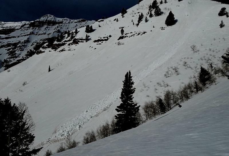
Clear skies, moderate gusts of wind, and overnight temperatures in the 30's provides a shallow refreeze of the snowpack this morning. However, it has been several days without a solid refreeze, so any supportable conditions will be short-lived at best. Yesterday observers were finding sunny aspects to be unsupportable by about 11 am, and given today's warm temperatures and strong sunshine, I think we'll be lucky to make it that late today. Be sure to get off of and out from underneath any steep slope once the snow surface becomes unsupportable. [Photo from Joey Dempster]
|
| type | aspect/elevation | characteristics |
|---|

|

|
LIKELIHOOD
LIKELY
UNLIKELY
SIZE
 LARGE
SMALL
TREND
 INCREASING DANGER
SAME
DECREASING DANGER
|
|
description
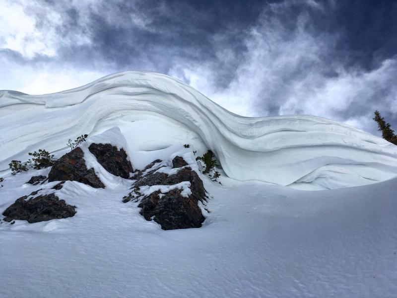
Huuuuuge cornices loom over many upper elevation ridge lines, and they become increasingly sensitive to both natural and human-triggered collapsing with warming temperatures. Although I do not think a cornice collapse will avalanche the slope below, the consequences of taking a ride down a slope along with the enormous chunks of snow are not inconsequential. [Photo from Mark White]
Brody Leven shared the following video of a cornice failure as he was traversing an upper elevation ridgeline on Mt. Timpanogos: |
| type | aspect/elevation | characteristics |
|---|
|
|
LIKELIHOOD
 LIKELY
UNLIKELY
SIZE
LARGE
SMALL
TREND
INCREASING DANGER
SAME
DECREASING DANGER
|
|
description
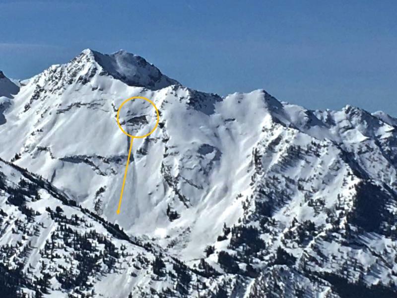
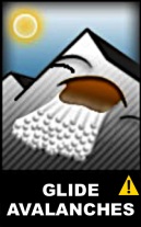
Many observers have noted large glide cracks, as well as recent glide avalanches, in the backcountry. Observers in the Provo mountains have also noted glide cracks starting to open. This past Tuesday a glide avalanche was reported from the Blue Ice region in Broads Fork. (Zoomed photo from Zimmerman/Wall)
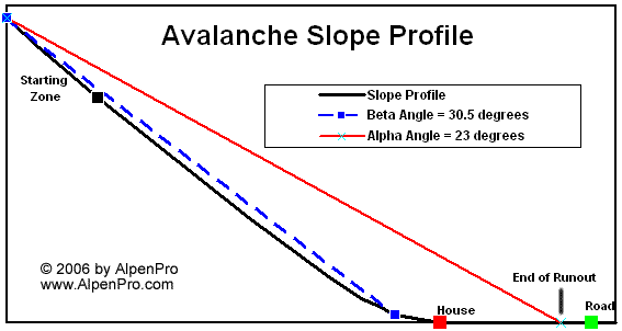
Glide avalanches are very unpredictable, but their activity tends to increase with warming temperatures. Glide releases are most common in Stairs Gulch, Broads Fork, and Mill B South of Big Cottonwood Canyon...but glide cracks have been noted in other isolated terrain across the range. If you are traveling in one of these drainages - or in similar terrain where you are noting glide avalanches - be sure to give the run out a very wide berth. (In avalanche-speak, this is known as the alpha angle which refers to the angle from the starting zone to the toe of the debris, and are often as shallow as about 20°. More on alpha angles can be found from this article.)
|
 |
weather Yawn. Another warm and sunny day with mountain temperatures rising into the 40's and 50's F. Winds this morning will be out of the west and gusting into the teens. Winds should decrease midday (which will accelerate warming of the snow surface), but then pick up in the afternoon out of the southwest. Winds increase overnight and into Saturday with very strong gusts (perhaps reaching the 60's mph along the ridges) as a very weak system moves in. Although precipitation late this weekend is forecasted at best to be light, whatever does fall is likely to be rain to 9500'. (Which, after this week, sounds rather nice.) A glimmer of hope in the extended outlook, especially by late this coming week. |
general announcements
|