25th Annual Black Diamond Fall Fundraising Party
Thursday, September 13; 6:00-10:00 PM; Black Diamond Parking Lot
25th Annual Black Diamond Fall Fundraising Party
Thursday, September 13; 6:00-10:00 PM; Black Diamond Parking Lot
| Advisory: Provo Area Mountains | Issued by Drew Hardesty for Tuesday - March 7, 2017 - 7:17am |
|---|

|
bottom line Areas of MODERATE danger exist for wind slabs on wind drifted slopes. Cracking and collapsing are potential red flags for localized instability. The danger of wet avalanches will rise to MODERATE with daytime warming on the east to south to west facing slopes.
|
 |
special announcement The Wasatch Powderkeg will be held this Friday and Saturday at Brighton as a benefit for the Utah Avalanche Center, featuring a Ski Mountaineering Sprint race on Friday afternoon and a longer race Saturday with Race, recreation, and youth courses and divisions. There will also be Companion Rescue, Terrain Strategies, Splitboarding, Steep Skiing and Riding, and Mountaineering Techniques for Skiers and Snowboarders skills clinics Saturday taught by local pros. There will be a drawing for great gear including boots and winner's choice of skis or a splitboard mid-day Saturday. Details here. Powder magazine has a companion piece to our Shame and the Social Contract essay from January. Editor Matt Hansen describes the uncomfortable position of reporting an avalanche in Getting Beyond the Emotional Game of Reporting an Avalanche. The take-home: Your reports of avalanche information matter. On this topic, a nod of appreciation to Aaron Rice in describing his incident in the Y-Not couloir a couple days ago...confirming that if you skin up over 2.5 million feet in a year, you're granted nine lives. |
 |
current conditions Skies are partly cloudy with temps in the teens. Winds are southwest, blowing 30mph with gusts to 40. Riding conditions are fair in the protected glades, but wind damage exists in the exposed terrain. Coverage is excellent with 90-120" on the ground in the Provo mountains. |
 |
recent activity Soft shallow wind slabs were triggered with ski cuts in myriad terrain yesterday not limited to the high elevations. |
| type | aspect/elevation | characteristics |
|---|

|

|
LIKELIHOOD
 LIKELY
UNLIKELY
SIZE
 LARGE
SMALL
TREND
 INCREASING DANGER
SAME
DECREASING DANGER
|
|
description
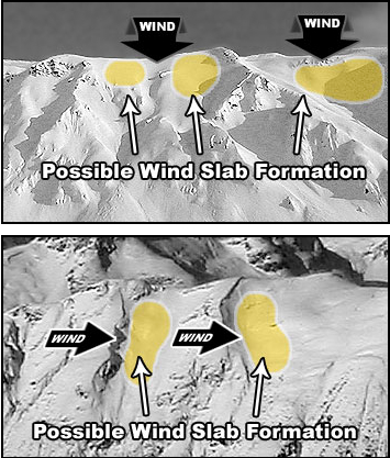
The westerlies will have produced an additional round of shallow soft and hard drifts on many aspects and elevations overnight. Don't be fooled into thinking that the drifts will only be along the higher ridgelines. Look for drifts to the lee of sub-ridges and around rocky outcroppings and other terrain features. Remember that shooting cracks and audible collapsing are red flags. In some areas, the signs will not be so obvious - as in the case of hard wind drifts. They often break out well above you and may do so on the 4th set of tracks on the slope. See pic below. In my travels yesterday, I used many test slopes to gauge the extent and sensitivity of the fresh wind slabs. Test slopes are key pieces of terrain in that - if targeted appropriately - are representative (steep, wind-loaded) of the the avalanche conditions while providing leniency of consequence.
|
| type | aspect/elevation | characteristics |
|---|

|
|
LIKELIHOOD
 LIKELY
UNLIKELY
SIZE
 LARGE
SMALL
TREND
 INCREASING DANGER
SAME
DECREASING DANGER
|
|
description
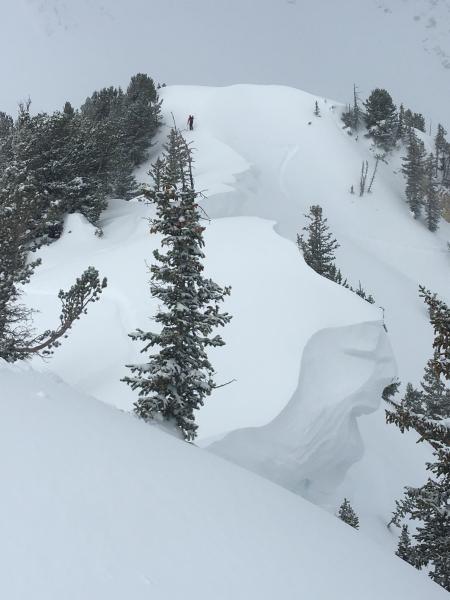
The Year of the Cornice. These behemoths are larger and more widespread than I can remember. A natural cornice fall along the south end of the Park City ridgeline last week snapped trees in the runout below. Utah has suffered more than a couple tragic events of people triggering and falling over with cornices. Another white whale below along the Cardiff Peak traverse to the Eyebrow.
|
| type | aspect/elevation | characteristics |
|---|

|

|
LIKELIHOOD
 LIKELY
UNLIKELY
SIZE
LARGE
SMALL
TREND
 INCREASING DANGER
SAME
DECREASING DANGER
|
|
description
With direct sun and warming temperatures, wind sheltered sunny slopes will become damp and unstable. Rollerballs, pinwheels, and minor loose wet sluffs are pre-cursors and indicators of wet snow instability. Avoid the steep, confined sunny slopes after they've become damp and saturated. |
 |
weather In general, we'll be under a westerly flow with a warming trend over the next several days. The westerly winds south of I-80 should become a more reasonable 15-20mph by early afternoon. Areas north of I-80 should continue to see moderate to strong winds along and north of the Utah/Idaho border over the next couple of days with more energetic waves passing to the north. Today we'll see partly cloudy skies and perhaps a trace of snow in the Ogden and Logan area mountains. Ridgetop temps will warm to the upper 20s. |
general announcements
|