25th Annual Black Diamond Fall Fundraising Party
Thursday, September 13; 6:00-10:00 PM; Black Diamond Parking Lot
25th Annual Black Diamond Fall Fundraising Party
Thursday, September 13; 6:00-10:00 PM; Black Diamond Parking Lot
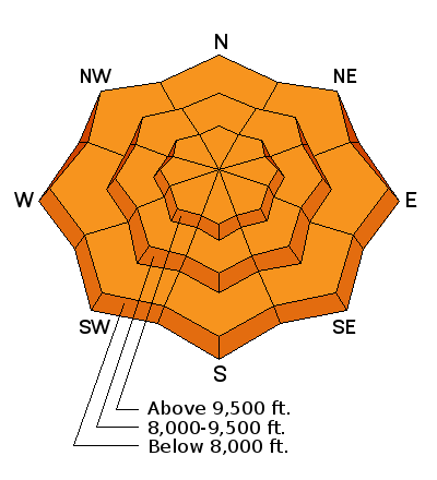
| Advisory: Provo Area Mountains | Issued by Evelyn Lees for Wednesday - February 8, 2017 - 7:17am |
|---|

|
bottom line The avalanche danger is CONSIDERABLE on steep slopes of all aspects and elevations. There are dense wind drifts that can be triggered at the mid and upper elevations, and wet snow sluffs and slabs that will be easy to trigger on all aspects at the mid and lower elevations. CONSIDERABLE means human triggered avalanches are likely on steep slopes. Excellent terrain and route finding skills are needed for backcountry travel to avoid steep slopes on all aspects and elevations. Many ice climbs in Little Cottonwood Canyon and Provo Canyon are directly in avalanche paths, and you could get hit from above as natural wet slides are still possible today.
|
 |
special announcement Thursday 2/9- This week the Utah Adventure Journal Speaker Series hosts professional ski-mountaineer Andrew McLean. Andrew has a PhD in mountain mistakes and will be sharing lessons learned from personal ski mountaineering experiences with avalanches, crevasses, long falls, getting lost, partner malfunctions and many other mountain mishaps. Andrew is the author of The Chuting Gallery and a veteran of over 25 skiing expeditions. For all event details click here. |
 |
current conditions Keeping with this winter’s maritime theme, the rain/snow line during yesterday’s intense windy storm was around 8000’ at times. Storm totals of heavy, dense snow and rain since Monday:
Yesterday’s nuking southwest to westerly winds have switched to the northwest and are decreasing this morning, with most stations now averaging less than 20 mph. Temperatures remained warm overnight in the Provo area mountains, with most stations still in the 30s this morning. Expect to find everything from slush to punchy, upside down snow and wind drifts today. |
 |
recent activity Provo - a widespread high elevation natural avalanche cycle occurred mid day during the heavy precipitation, in addition to wet avalanches from control work and natural wet avalanches gouging to the ground on steep road banks between 6 and 7000’. Salt Lake/Park City: a wet loose sluff triggered on a west-facing slope at 8400’, triggered a slab avalanche 12” deep by 125 feet wide. A large natural cornice fall was observed on east facing Reynolds. Resorts reported both long running sluffs and wind slabs released with both explosives and ski cuts. Ogden area mountains – few observations, but yesterday’s North Ogden Divide and Powder Mountain road closures help tell the story |
| type | aspect/elevation | characteristics |
|---|

|
|
LIKELIHOOD
 LIKELY
UNLIKELY
SIZE
 LARGE
SMALL
TREND
 INCREASING DANGER
SAME
DECREASING DANGER
|
|
description
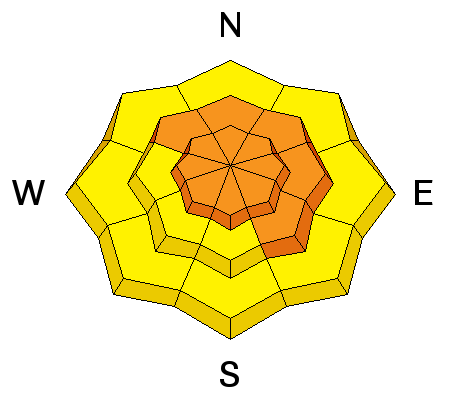
Yesterday’s strong southwest to westerly winds blew the dense snow into moderate to hard winds slabs. These dense, stubborn drifts will be found both along ridge lines and down mid slope. They will be most widespread on northwest through southeasterly facing slopes, but watch for drifts cross loaded into other pockets. Strong winds tend to make deep, more isolated pockets, and you can quickly go from wind scoured to wind drifted in a very short distance. A slide starting out as dry snow could change to wet characteristics as it moves down hill in the Provo area mountains, making it even more dangerous. Both old and new cornices will remain sensitive, and tend to break back further than you would expect. |
| type | aspect/elevation | characteristics |
|---|

|
|
LIKELIHOOD
LIKELY
UNLIKELY
SIZE
 LARGE
SMALL
TREND
 INCREASING DANGER
SAME
DECREASING DANGER
|
|
description
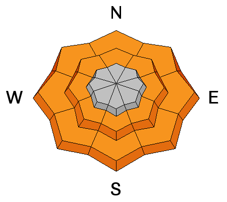
The Provo mountians were the epicenter for rain and wet snow yesterday, and the low and mid elevation snow is wet and sloppy today on all aspects. It will be very easy to trigger wet loose sluffs, and these sluffs or a person may even trigger a wet slab avalanche. Wet avalanches have dense, cement like debris. A large wet slide would be unsurvivable, and even a small wet slide in a small steep terrain features such as house roofs and road and creek banks can pile up enough debris to bury a person. Sensitivity of the wet snow will peak with the heat of the day or any time a slope gets direct sun. Plan your travel carefully to avoid steep slopes of all aspects at the lower elevations. Left: rollar balls - a sign of unstable wet snow Right: Cardiff slide, where a wet loose sluff triggered a slab avalanche
|
| type | aspect/elevation | characteristics |
|---|

|
|
LIKELIHOOD
 LIKELY
UNLIKELY
SIZE
LARGE
SMALL
TREND
INCREASING DANGER
SAME
DECREASING DANGER
|
|
description
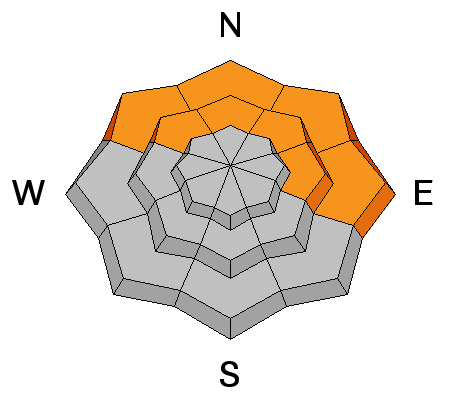
Yesterday, I looked at the buried surface hoar layer at a lower elevation in Summit Park, and it was as weak as ever. The warmth and rain don’t seem to have reached or changed this persistent weak layer yet, so it will still be possible to trigger an avalanche breaking on this layer, perhaps even a bit more sensitive with the added weight of a few inches of snow. These persistent buried weak layers of surface hoar or small faceted crystals on an ice crust mostly exist on low and mid elevation shady slopes at the northern end of the Park City ridgeline to Parleys Canyon. |
 |
weather Today is the break between storms, with partly cloudy skies and decreasing winds. Temperatures will be near tropical – warming to 40 at 8000’, and to near 30 at 10,000’. The west to northwesterly winds should slowly decrease throughout the day, ending up in the 10 to 15 mph range, with gusts in the 30 and 40s. Only the highest peaks should still be averaging 35 mph by the end of the day. I’m really starting to like the term “atmospheric river”…the next exciting warm, windy storm will affect the area late Thursday night through Friday, producing heavy snow, strong winds and another high rain/snow line. |
general announcements
|


