25th Annual Black Diamond Fall Fundraising Party
Thursday, September 13; 6:00-10:00 PM; Black Diamond Parking Lot
25th Annual Black Diamond Fall Fundraising Party
Thursday, September 13; 6:00-10:00 PM; Black Diamond Parking Lot
| Advisory: Provo Area Mountains | Issued by Drew Hardesty for Saturday - February 4, 2017 - 7:33am |
|---|


|
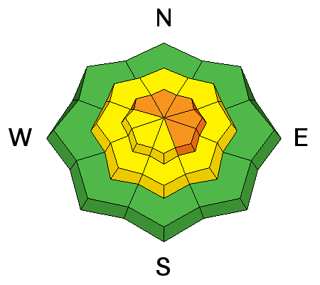
bottom line Areas of Considerable danger exist up high for wind drifted snow at the upper elevations. Isolated areas of MODERATE danger exists on mid and low elevation slopes facing northwest through east where slab avalanches up to 2 feet deep can be triggered failing on a buried layer of surface hoar. Faceted weak layers also exist on other aspects and elevations, but are more isolated.
|
 |
special announcement Also - for those that enjoy podcasts - Doug Krause has an excellent new avalanche-related podcast appropriately named Slide. It is a nice combination of practical advice, snow science, as well as human factor issues. Last, and certainly least: if you have time to kill, check out our recorded live Instagram digital fireside chat from Wednesday night. These fireside chats are informal discussions on the state of the snowpack and involve questions and comments from viewers. We hope to have more in the coming weeks. |
 |
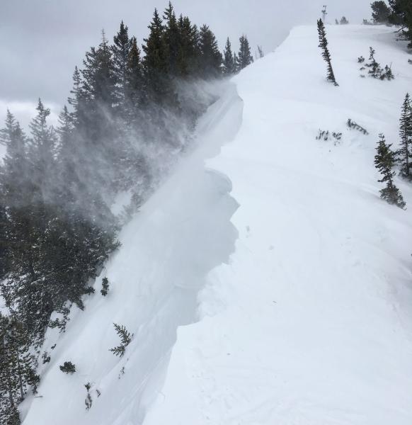
current conditions The wind. Hoods extended, goggles on, yesterday we bent against the wind as faceless, nameless penitents as if in supplication to some unknown and unknowable weather gods. We were not alone. We shared the ridgelines with krummholz, the stunted, twisted and forever leewardly bent-in-supplication conifers. Krummholz might best be translated from the German as "old man", and it's obvious why. As of 5am, we've received another 4" on a southwesterly flow with densities in the 15-17% range. Mountain temperatures are in the upper 20s. Winds are now westerly, blowing 25-30mph with gusts to 40. Snow surface conditions: thick powder snow in the protected northerly terrain, lipstick on a pig dust on coarse, corrugated melt-freeze crusts on the sunny aspects, and generally damp "coastal" powder in the lower elevations. (pic: M.White)
|
 |
recent activity In the Ogden and Salt Lake mountains yesterday, activity centered around shallow pockets of soft sensitive wind drifts 4-8" deep and up to 35' wide on many aspects at the mid and upper elevations. (pics: Bill Hunt).
|
| type | aspect/elevation | characteristics |
|---|

|
|
LIKELIHOOD
 LIKELY
UNLIKELY
SIZE
 LARGE
SMALL
TREND
 INCREASING DANGER
SAME
DECREASING DANGER
|
|
description
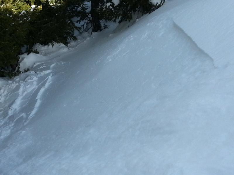
Winds swirled in all directions yesterday. Along the upper reaches of the Big Cottonwood/Little Cottonwood divide, I found shallow drifts on east facing aspects, west facing aspects and in many deceleration zones well off the ridgelines. None of these were big enough to bury you, but the additional overnight snow and wind will make these a touch more problematic - particularly in and above committing and unforgiving terrain. Ski cuts and cornice drops should be effective mitigation tools for experienced practitioners; however avoidance of the smooth and rounded drifts while powder hunting in the low angle trees is always a good bet. Remember that cracking (below) and thick, slabby texture are often red to yellow signs of instability. (pic: C.Frantz) |
| type | aspect/elevation | characteristics |
|---|

|
|
LIKELIHOOD
 LIKELY
UNLIKELY
SIZE
LARGE
SMALL
TREND
INCREASING DANGER
SAME
DECREASING DANGER
|
|
description
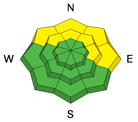
These persistent slabs haven't yet been found to be reactive in the Provo area mountains, however we're hesitant to altogether write them off without more data. They are called persistent slabs for a reason. Although the last human-triggered slide on our persistent weak layer was reported on Tuesday, we're not ready to put this problem to rest. There are two different layers to search for: (1) a layer of surface hoar, and (2) a layer of near-surface facets sitting just above a crust. These weaknesses have been most reactive on the northern end of the Park City ridgeline, extending to Parleys Canyon. They are found primarily on northwest through east aspects, on sheltered low and mid elevation terrain and generally 2' deep. Thursday's video below by our friends at AAI (American Avalanche Institute) well illustrates the results of two propagation tests. Note how the surface hoar feathers explode up off the interface with the slow-motion propagation saw test! YouTube video here - |
| type | aspect/elevation | characteristics |
|---|

|
|
LIKELIHOOD
 LIKELY
UNLIKELY
SIZE
LARGE
SMALL
TREND
INCREASING DANGER
SAME
DECREASING DANGER
|
|
description
Watch for loose wet avalanche activity on steep slopes on all aspects at lower elevations. There is also still a chance for roof avalanches today with warm temps - stay out from under any roof that still holds a significant amount of snow. Rollerballs and natural sluffs are key indicators; if you find yourself in soggy, unsupportable snow, avoid steep terrain, especially that which dumps into terrain traps such as creekbeds. |
 |
weather Light snow should continue for the next couple of hours before tapering off. Mountain temperatures will be in the mid-20s with west to southwest winds blowing 20-25mph. The next storm arrives Monday through the early part of the week. Strong southerly winds also accompany this system until Monday night's frontal passage, ushering in additional snow and much cooler temps. |
general announcements
|