25th Annual Black Diamond Fall Fundraising Party
Thursday, September 13; 6:00-10:00 PM; Black Diamond Parking Lot
25th Annual Black Diamond Fall Fundraising Party
Thursday, September 13; 6:00-10:00 PM; Black Diamond Parking Lot
| Advisory: Provo Area Mountains | Issued by Evelyn Lees for Wednesday - February 1, 2017 - 7:19am |
|---|

|
bottom line The avalanche danger is MODERATE on wind drifted, upper elevation slopes, and the drifts will be most widespread on northwest through easterly facing slopes. The avalanche danger is also MODERATE on mid and low elevations slopes facing northwest through east where slab avalanches up to 2 feet deep can be triggered failing on a buried layer of surface hoar. Small wet loose sluffs can be triggered if the snow becomes damp where you are.
|
 |
special announcement Instagram Chat tonight with Drew Hardesty! Wednesday Feb 1, at 7pm We want to hear from you! Drew will be on Instagram live tonight from 7-8pm. Comment on Instagram any questions or concerns you may have with our current backcountry avalanche conditions. If you miss the live feed, we'll have it available on our YouTube account to watch after. You can send us questions via Facebook message or email [email protected] Thursday February 2nd - Utah Adventure Journal hosts professional adventure skier Mike Marolt, a high altitude skier with 30 years of expeditions to some 50 of the world’s 6,000 to 8,000 meter peaks. For this event, he will be screening Skiing Everest, a feature length documentary film profiling he and his identical twin brother in their pursuit of high altitude skiing in the late 90’s. For details click here. |
 |
current conditions It’s a warm, windy, cloudy morning, with temperatures in the Provo area mountains generally in the 30s at the low to mid elevations. Winds blew from the southwest overnight, and at their strongest the mid elevation Provo station averaged to 25 mph, gusting to 40 pmh. The highest peaks to the north reached average speeds in the 50s for several hours. |
 |
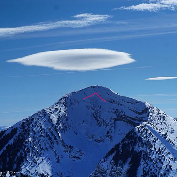
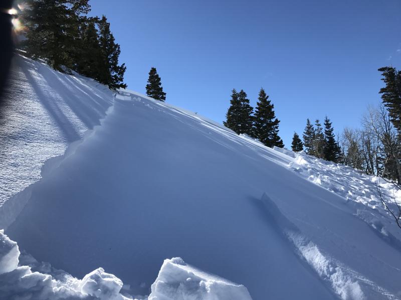
recent activity Yesterday, a slab avalanche was triggered on a very low angle north facing slope at 8200’ in Summit Park. It failed on the now notorious “Parley’s surface hoar”, and was about 18” deep by 200’ wide. Reactive surface hoar was also found in a pit at 8000' Days Fork. And from a distance, a very wide slide was observed in north facing Super Couloir on Box Elder peak, thought to be a new wind slab. Top: Joey Campanellie photo, wind slab on Box Elder Below: – Brackelsberg photo, Summit Park slide failing on surface hoar.
|
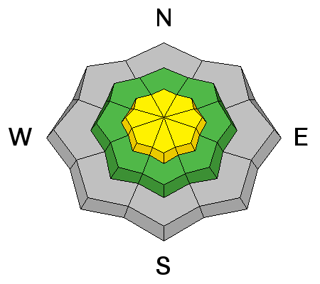
| type | aspect/elevation | characteristics |
|---|

|
|
LIKELIHOOD
 LIKELY
UNLIKELY
SIZE
 LARGE
SMALL
TREND
 INCREASING DANGER
SAME
DECREASING DANGER
|
|
description
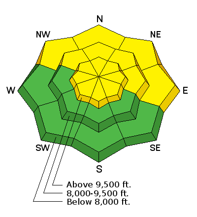
New wind slabs will be the main issue today at the upper elevations. Last night’s west to southwest winds were the strongest we’ve seen in days, so they will have found some snow to erode and drift into hard, cracky slabs. While the drifts will be most widespread on upper elevation northwest through easterly facing terrain, watch for pocket drifts cross loaded onto other aspects around sub ridges and gully walls and at the mid elevations. |
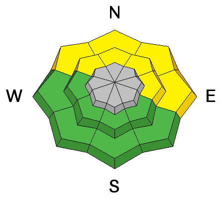
| type | aspect/elevation | characteristics |
|---|

|
|
LIKELIHOOD
 LIKELY
UNLIKELY
SIZE
LARGE
SMALL
TREND
INCREASING DANGER
SAME
DECREASING DANGER
|
|
description
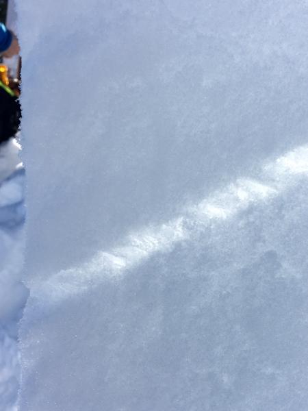
The surface haor weak layer is less widespread in the Provo area mountains, but has been found. Check out this observation from January 26th. I took a look at the stunning buried surface hoar layer in the Summit Park area yesterday, as impressive as I’ve seen in years. The surface hoar is most widespread in wind sheltered, shady low and mid elevation terrain, with the Parley Summit area from Murdock through Mt Aire seeming to be the epicenter for the most widespread preservation. The best way to find this layer is to get a shovel out and look for the “stripe” about 2 feet down. On the east through south through northwesterly facing slopes, a crust/facet layer exists, but seems to be less sensitive at the moment. These faceted layers can be triggered remotely from a distance or from low angle slopes. In some areas, the facets have become more stubborn, and could wait to fail until you’re mid slope, breaking above you. Can surface hoar strengthen? Over time, it is believed one way surface hoar strengthens is the layer thin over time as the surface hoar crystals are “pushed” into the slab above and below. But larger crystals are more persistent than smaller ones. Left: thick layer of buried surface hoar, Toll Canyon Right: from Jamieson/Schweizer paper
|
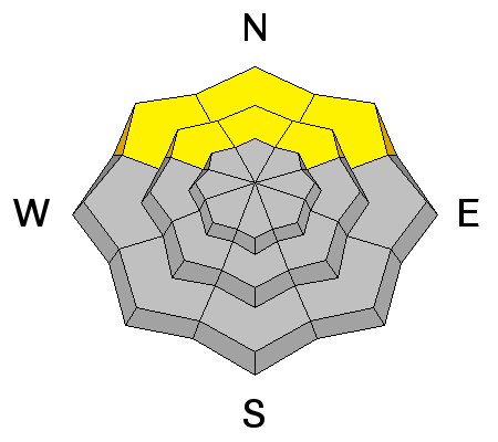
| type | aspect/elevation | characteristics |
|---|

|
|
LIKELIHOOD
 LIKELY
UNLIKELY
SIZE
 LARGE
SMALL
TREND
 INCREASING DANGER
SAME
DECREASING DANGER
|
|
description
While the sunny slopes have gone through numerous melt freeze cycles, the snow on some of the low and mid elevation shady slopes may warm for the first time today. If the snow surface gets damp, expect to be able to “push” the damp snow into wet sluffs. Even with warm overnight temperatures, winds and clouds should keep the snow cool on most other aspects and elevations today. |
 |
weather We are stuck in the doldrums as a ridge of high pressure limits our weather to periods of clouds and wind. Today, mostly cloudy skies, with another short period of strong and gusty winds this morning. By mid day, the westerly winds should decrease into the 10 to 15 mph range, with even the high peaks averaging only around 30 mph. 10,000’ temperatures will be around freezing, before cooling into the twenties tonight. Weak, warm “storms” will bring a few inches of snow to the mountains late Thursday and again on Friday, with the rain/snow line around 6000’ at times. |
| general announcements Remember your information can save lives. If you see anything we should know about, please help us out by submitting snow and avalanche conditions. You can also call us at 801-524-5304, email by clicking HERE, or include #utavy in your tweet or Instagram. To get help in an emergency (to request a rescue) in the Wasatch, call 911. Be prepared to give your GPS coordinates or the run name. Dispatchers have a copy of the Wasatch Backcountry Ski map. Backcountry Emergencies. It outlines your step-by-step method in the event of a winter backcountry incident. If you trigger an avalanche in the backcountry, but no one is hurt and you do not need assistance, please notify the nearest ski area dispatch to avoid a needless response by rescue teams. Thanks.
EMAIL ADVISORY If you would like to get the daily advisory by email you will need to subscribe here. DAWN PATROL Hotline updated daily by 5-530am - 888-999-4019 option 8. TWITTER Updates for your mobile phone - DETAILS UDOT canyon closures: LINK TO UDOT, or on Twitter, follow @UDOTavy, @CanyonAlerts or @AltaCentral Utah Avalanche Center mobile app - Get your advisory on your iPhone along with great navigation and rescue tools. Powderbird Helicopter Skiing - Blog/itinerary for the day Lost or Found something in the backcountry? - http://nolofo.com/ To those skinning uphill at resorts: it is critical to know the resort policy on uphill travel. You can see the uphill travel policy for each resort here. Benefit the Utah Avalanche Center when you shop from Backcountry.com or REI: Click this link for Backcountry.com or this link to REI, shop, and they will donate a percent of your purchase price to the UAC. Both offer free shipping (with some conditions) so this costs you nothing! Benefit the Utah Avalanche Center when you buy or sell on ebay - set the Utah Avalanche Center as a favorite non-profit in your ebay account here and click on ebay gives when you buy or sell. You can choose to have your seller fees donated to the UAC, which doesn't cost you a penny. This information does not apply to developed ski areas or highways where avalanche control is normally done. This advisory is from the U.S.D.A. Forest Service, which is solely responsible for its content. This advisory describes general avalanche conditions and local variations always exis |