25th Annual Black Diamond Fall Fundraising Party
Thursday, September 13; 6:00-10:00 PM; Black Diamond Parking Lot
25th Annual Black Diamond Fall Fundraising Party
Thursday, September 13; 6:00-10:00 PM; Black Diamond Parking Lot
| Advisory: Provo Area Mountains | Issued by Trent Meisenheimer for Tuesday - January 31, 2017 - 6:05am |
|---|


|
bottom line Today the avalanche danger is MODERATE. The most dangerous and unpredictable avalanche problem is at low and mid elevations where you could still trigger a persistent slab avalanche. At the highest elevations watch for wind slabs, and as the day heats, watch for wet loose avalanches on the southerly aspects.
|
 |
special announcement Do you buy groceries at Smiths? Register your Smith’s rewards card with their Community Rewards program, and they will donate to the Utah Avalanche Center whenever you make a purchase. It's easy, only takes a minute, and doesn't cost you anything. Details |
 |
current conditions This morning temperatures are a bit warmer - 9000' temperatures are in the mid 20's while in the lower canyon temps are in the upper teens. Winds will be the bummer as they have increased out of the west-north-west and are expected to hang around for the day. Upper elevation ridge lines are already blowing 15-20 mph gusting into the 30's. Sunny slopes on the southern half of the compass will have a crust. Shady aspects on the north half of the compass have soft settled powder. |
 |
recent activity Yesterday the only avalanche activity reported was due to heat. Most of these were avoidable and were caused by the strong solar input on sunny aspects. No significant avalanche activity was reported yesterday. However, there are plenty of avalanches to sift through from the past few days. You can find a full list of recent avalanches for the Provo area HERE.
|
| type | aspect/elevation | characteristics |
|---|

|
|
LIKELIHOOD
 LIKELY
UNLIKELY
SIZE
 LARGE
SMALL
TREND
 INCREASING DANGER
SAME
DECREASING DANGER
|
|
description
Last night and this morning, strong winds continue to blow from the west at the higher elevations, forming wind slabs off the lee side of ridgelines. Watch for fresh new drifts of wind blown snow at the upper elevations today. As you ride back to the trailhead and lose elevation, your attention should shift to the persistent slab avalanche problem. |
| type | aspect/elevation | characteristics |
|---|

|

|
LIKELIHOOD
 LIKELY
UNLIKELY
SIZE
LARGE
SMALL
TREND
INCREASING DANGER
SAME
DECREASING DANGER
|
|
description
Strong sunshine will cause more wet loose avalanches today. Although, it's not supposed to be as hot as yesterday and some wind could keep this danger at bay. You'll know the danger for this avalanche problem is increasing because the snow will become wet, and small wet slides will start occurring. If you're on the south half of the compass this morning and start seeing roller balls coming down - you'll know it's time to leave - be sure not to over stay your welcome. Photo: E. Maginnn from Timpanogos
|
| type | aspect/elevation | characteristics |
|---|

|
|
LIKELIHOOD
LIKELY
UNLIKELY
SIZE
 LARGE
SMALL
TREND
 INCREASING DANGER
SAME
DECREASING DANGER
|
|
description
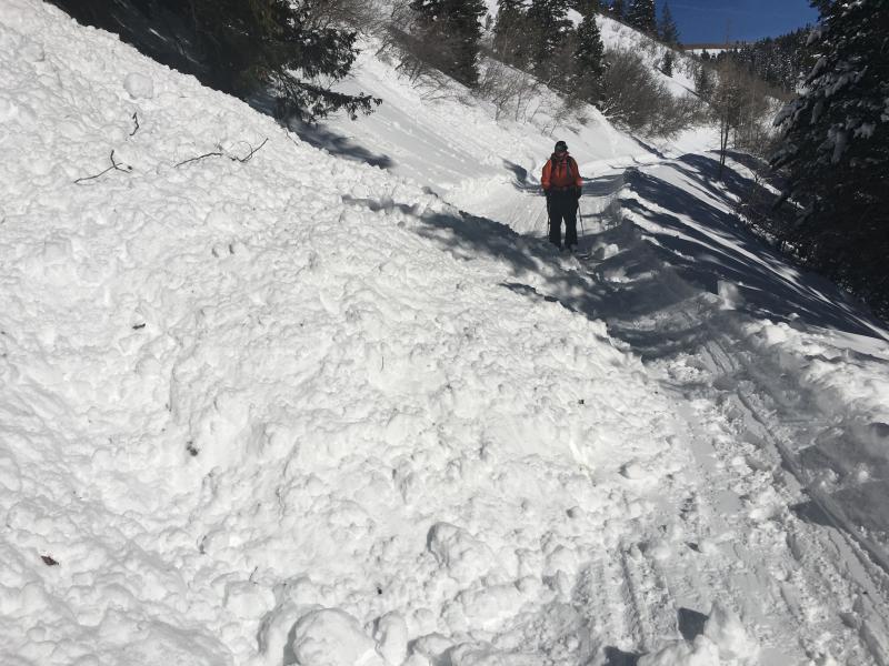
A layer of surface hoar or small faceted crystals near on an ice crust can produce persistent slab avalanches today 2-4 feet deep and several hundred feet wide in specific terrain. Unfortunately, slopes that harbor these layers are wind sheltered slopes that are not obvious avalanche terrain. They seem benign but possibly conceal a deadly layer beneath your feet. The good news: Knowing if these layers exist on a slope is easy. Dig only 4 feet deep on a low angle slope at a similar aspect and elevation to one you hope to ski or ride. You may see an obvious stripe of surface hoar which is a bad sign. Or you may find an ice crust with small facets. Either way, doing a quick stability test like the ECT will help you find these layers because the column will cleanly fracture on them (propagation). What if you don't find these layers? These layers don't exist everywhere and many slopes are stable. If you don't find them, this avalanche problem probably isn't an issue BUT you'll have to dig more snowpits as you move around. Here is a video about one of Friday's avalanches that caught a skier who deployed his air bag just south of Murdock Peak on the Park City Ridgeline. |
 |
weather West winds will remain gusty throughout the day today and will usher in some high clouds this afternoon. Temperatures will rise into the upper 30's to low 40's at 9000'. Expect some of the valley stratus and fog to slowly creep up the canyons as the day wears on. We do have a cooling trend on tap starting today and continuing to get cooler each day this week. By Thursday afternoon into Friday we could see a few snow flakes beginning to fall as a weak storm moves in. The next storm that has potential to clear the inversion and bring snow is Monday next week - However, I wouldn't hold your breath just yet - except if you're in the valley. |
general announcements
|