25th Annual Black Diamond Fall Fundraising Party
Thursday, September 13; 6:00-10:00 PM; Black Diamond Parking Lot
25th Annual Black Diamond Fall Fundraising Party
Thursday, September 13; 6:00-10:00 PM; Black Diamond Parking Lot
| Advisory: Provo Area Mountains | Issued by Mark Staples for Thursday - January 26, 2017 - 7:23am |
|---|


|
bottom line The avalanche danger today is CONSIDERABLE which requires careful snowpack evaluations. Mid and low elevation slopes that seem safe may be the most dangerous because they may have a layer of surface hoar or small faceted crystals buried 2-3 feet deep. There is a lot of uncertainty about the distribution of this layer. There's a very good chance this layer exists and will produce avalanches on steep slopes near creeks, gullies and other terrain traps where a small avalanche can create a deep debris pile.
|
 |
special announcement Do you buy groceries at Smiths? Register your Smith’s rewards card with their Community Rewards program, and they will donate to the Utah Avalanche Center whenever you make a purchase. It's easy, only takes a minute, and doesn't cost you anything. Details |
 |
current conditions This morning temperatures are mostly in the upper single digits F with light NW winds. Since yesterday a trace to 2 inches of very light snow fell. Friday and Saturday's low density snow was followed by warmer, heavier snow on Sunday and Monday creating upside down conditions (heavy snow on top of light snow). Since then much lighter snow has fallen creating outstanding riding and right side up conditions (light snow on top of heavy snow). The combination of light winds, cloudy skies, and cold temperatures has kept great powder on most slopes. |
 |
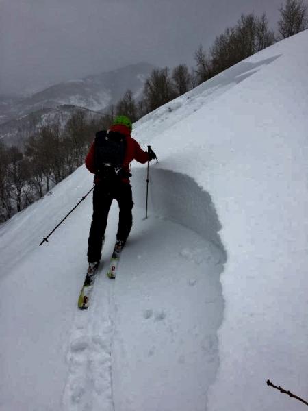
recent activity Yesterday a skier was caught and carried in a slide on Mt Aire which is just west of Lambs Canyon along I-80. While this slide occurred closer to SLC, it is still relevant for the Provo area mountains. Fortunately he was not buried or injured. He was the second skier to descend the slope. My partners and I looked at this slide yesterday and found widespread buried surface hoar about 2 feet deep on W, N and E aspects. A preliminary report is available HERE and more detailed info will be posted later today. Video about the accident. There have been other slides occuring on buried surface hoar on slopes below 8000 feet where we don't see avalanches as frequently as at higher elevations like one triggered near the Utah Olympic Park. This one was triggered from flat terrain some distance away from the slope that avalanched, a bad sign. See the photo below (A. Rich). There have been other slides you can view HERE. Additionally, ski patrollers along the Park City ridgeline spotted many avalanches in the backcountry, some breaking on surface hoar with others simply breaking in the new snow.
|
| type | aspect/elevation | characteristics |
|---|

|
|
LIKELIHOOD
 LIKELY
UNLIKELY
SIZE
 LARGE
SMALL
TREND
 INCREASING DANGER
SAME
DECREASING DANGER
|
|
description
Persistent slab avalanches have been triggered layer of buried surface hoar or on a layer small, faceted crystals buried 2-3 feet deep. Unfortunately we have not determined the exact distribution of these layers which is why I have rated the danger Considerable at all aspects and elevations. Fortunately, this layer is easy to find in a clean snowpit wall. It should also break cleanly and propagate cracks in stability tests. This layer seems most prevalent on low to mid elevation slopes sheltered from wind and probably doesn't exist at upper elevations. Even on southerly aspects, there may be weak layers near crusts as Evelyn found on Tuesday. To ride in avalanche terrain, dig about 4 feet deep, do stabilty tests like the ECT, and make sure this layer doesn't exist. A lack of cracking or collapsing or other obvious signs of instability does not mean slopes are stable. Tracks from other people don't indicate stability either. Photo and video below of the surface hoar in an avalanche crown on Mt Aire yesterday.
|
| type | aspect/elevation | characteristics |
|---|

|

|
LIKELIHOOD
LIKELY
UNLIKELY
SIZE
LARGE
SMALL
TREND
INCREASING DANGER
SAME
DECREASING DANGER
|
|
description
There has simply been A LOT of snow during the last 5 days (over 4 inches of snow water equivalent). Many avalanches were breaking on low density snow that fell Friday and Saturday. Fortunately this snow is settling, compressing, and gaining strength. Watch for and avoid large cornices which may still be straining under the weight of all the new snow. Lastly, very light snow that has fallen during the last several days may create loose snow sluffs. |
 |
weather Today will remain cold with NW winds and occasional snowfall. Temperatures will rise into the teens F, and winds should average 5-15 mph in most places. By the end of today only an inch or two should accumulate but will favor upper Little Cottonwood Canyon. Clear, sunny skies and slowly warming temperatures will arrive tomorrow through the weekend. |
general announcements
|