25th Annual Black Diamond Fall Fundraising Party
Thursday, September 13; 6:00-10:00 PM; Black Diamond Parking Lot
25th Annual Black Diamond Fall Fundraising Party
Thursday, September 13; 6:00-10:00 PM; Black Diamond Parking Lot
| Advisory: Provo Area Mountains | Issued by Trent Meisenheimer for Tuesday - January 24, 2017 - 6:51am |
|---|


|
bottom line The avalanche danger is HIGH on mid and upper elevation terrain, and CONSIDERABLE in all other terrain. TRAVEL IN AVALANCHE TERRAIN IS NOT RECOMMENDED. You need stay off of and out from under steep terrain, and avoid avalanche runout zones.
There is unusually weak snow at lower elevations. While these avalanches may be smaller, debris can pile up dangerously deep in terrain traps such as gullies, creek beds, and below steep road banks. Today is not the day to walk or travel below any avalanche terrain.
|
 |
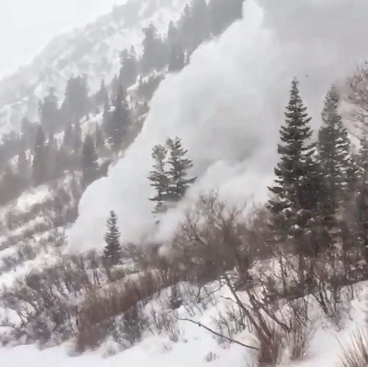
avalanche warning THE FOREST SERVICE UTAH AVALANCHE CENTER IN SALT LAKE CITY HAS EXTENDED THE BACKCOUNTRY AVALANCHE WARNING. * TIMING...IN EFFECT THROUGH 6AM WEDNESDAY. * AFFECTED AREA...FOR THE MOUNTAINS OF NORTHERN UTAH INCLUDING THE WASATCH RANGE...WESTERN UINTA MOUNTAINS...BEAR RIVER RANGE...AND THE MOUNTAINS OF SOUTHEAST IDAHO. * AVALANCHE DANGER...HIGH. * REASON/IMPACTS...HEAVY DENSE SNOW COMBINED WITH STRONG WINDS HAS CREATED WIDESPREAD AREAS OF UNSTABLE SNOW AT ALL ELEVATIONS INCLUDING LOW ELEVATION TERRAIN. BOTH HUMAN TRIGGERED AND NATURAL AVALANCHES ARE LIKELY. STAY OFF OF AND OUT FROM UNDER SLOPES STEEPER THAN 30 DEGREES. |
 |
special announcement Little Cottonwood Canyon and MANY other mountain passes are closed this morning. The canyon roads will be changing backcountry closures, and updates will be issued all day. You need to follow @UDOTavy or us on twitter, or check the UDOT info on our home page. UDOT commuter link found here. If you sign up for AmazonSmile and designate the Utah Avalanche Center as your favorite charity, they will donate a portion of everything you spend to the UAC. I doesn't cost you a penny and we'd really appreciate the help. New Date for this! Drew will be hosting the Fireside Chat at the Black Diamond store this Wednesday at 7pm. Topic: Expert Intuition in High Risk - Low Frequency Events. Best if you have a decent grasp of the different avalanche problems, but all are welcome to this informal, low key, picnic - style gathering. |
 |
current conditions What a storm - 36 hr snow totals are:
Under a northwest flow this morning, temperatures are in the upper teens at many trail heads and single digits at upper elevations. Yesterday's southwest winds shifted to the northwest as a cold front pushed through around 3:00 pm. The pesky winds finally relaxed and upper elevation wind speeds are from the southwest 15-20 mph with the occasional gust into the low 30's. Trail breaking is a chore and the snow was reported to be upside down. Riding and turning will get better with time as the snow settles. |
 |
recent activity Yesterday, the heavy snow and strong south winds produced a natural avalanche cycle mid morning on many aspects and elevations. Avalanche control teams had their hands full and many reported avalanches up to size 3 on the destructive scale (size 3 means - could bury, kill a human, destroy a car, damage a truck, destroy a wood frame house or break trees). Avalanches were running fast and long distances. Sizable natural avalanche was heard yesterday by a UDOT employee while at a snow study plot in Aspen Grove. Thinking Primrose or Elk Point avalanched. Up north a car was buried when UDOT was trying to clear and close the highway. The car was buried with people inside, UDOT quickly responded to the scene and evacuated the trapped people - nobody was injured in the avalanche. Backcountry travelers reported collapsing and cracking and took note of many natural avalanches. Click HERE to read more recent observations. Photo: Control results from UDOT in Little Cottonwood Canyon. Photo: Mark White from Mill D North. Read ob HERE
|
| type | aspect/elevation | characteristics |
|---|

|
|
LIKELIHOOD
 LIKELY
UNLIKELY
SIZE
 LARGE
SMALL
TREND
 INCREASING DANGER
SAME
DECREASING DANGER
|
|
description
Wind slabs will be found both along the ridge lines and in open bowls, cross loaded around sub ridges and break overs in mid and upper elevation terrain. Smaller slabs can be found well into the lower elevation terrain. I don't expect to see many, if any, natural avalanches today caused by wind. Most of these monster wind slabs are just waiting for a trigger and will be very sensitive to human triggers. These wind slabs will be hard to identify with 5-10" of powder snow now covering them up. VERY DANGEROUS AVALANCHE CONDITIONS. Travel in avalanche terrain in NOT recommended. Avoid being on or under any terrain approaching 30 degrees in steepness. Photo: Mark White, Scotts Hill, 9700’.
|
| type | aspect/elevation | characteristics |
|---|

|
|
LIKELIHOOD
 LIKELY
UNLIKELY
SIZE
 LARGE
SMALL
TREND
INCREASING DANGER
SAME
DECREASING DANGER
|
|
description
Even in wind-sheltered terrain, the dense new snow has formed a slab over the low-density powder from the past few days. Avalanches can be triggered in sheltered areas. |
| type | aspect/elevation | characteristics |
|---|

|
|
LIKELIHOOD
LIKELY
UNLIKELY
SIZE
LARGE
SMALL
TREND
 INCREASING DANGER
SAME
DECREASING DANGER
|
|
description
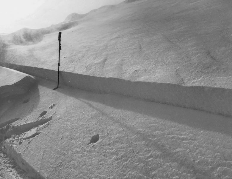
The persistent faceted layer we are most concerned about is the snow that was on the surface last week (see picture below). It’s most widespread in more sheltered, mid to low elevation terrain. Slides breaking on this layer will only be slightly deeper than new snow slides, but more tricky. They could be triggered remotely from a distance or from below, or they can be stubborn and break above you when you’re mid slope. Also, a smaller new snow slide could step down, creating a deeper, wider and more dangerous avalanche. Collapsing is a sure sign of instability. A rain crust was observed up to 8300' in the Sundance area. Snow saftey reported a natural avalanche cycle at 2:00 pm yesterday and they suspected avalanches were failing above this crust. It's now buried roughly 16'' deep. Heads up! - Lower canyon, and other odd aspects and elevations - you will find a variety of buried thin and thick crusts, some with associated facets (see picture below). These could act as weak layers or bed surfaces, and distribution is complicated. For now let the lower elevations also adjust to their new load. Photo: Jake Hutchinson showing us the layer of most concern. Read his observation and watch his excellent video here.
|
 |
weather We will remain under a cold northwest flow for today and tomorrow. A small storm will move into the mountains this afternoon bringing snow flurries at times with accumulations of 2-4 inches of snow. Winds will remain light out of the north west and average 10-20 mph with occasional gust into the 20's at mid to upper elevations. Tonight snow will taper off ahead of another small storm that will bring similar snow flurries to the mountains on Wednesday. Temperatures will remain cold into Thursday, with a warming trend and high pressure to follow on Friday. |
general announcements
|