25th Annual Black Diamond Fall Fundraising Party
Thursday, September 13; 6:00-10:00 PM; Black Diamond Parking Lot

25th Annual Black Diamond Fall Fundraising Party
Thursday, September 13; 6:00-10:00 PM; Black Diamond Parking Lot
| Advisory: Provo Area Mountains | Issued by Greg Gagne for Friday - January 20, 2017 - 7:01am |
|---|
 |
special announcement If you sign up for AmazonSmile and designate the Utah Avalanche Center as your favorite charity, they will donate a portion of everything you spend to the UAC. I doesn't cost you a penny and we'd really appreciate the help. Read a great new blog post by forecaster Drew Hardesty - Shame and the Social Contract |
 |
current conditions Temperatures range throughout the teens and low twenties in theProvo mountains and southwest winds are light, gusting to less than 10 mph. Snowfall totals from Thursday are generally 1 - 2" in the Provo mountains. Despite ample available moisture, the lack of orographic lift on Thursday limited snowfall totals. Week in Review Not much to report. A dominant ridge of high pressure with clear skies and cold nights through late this past week and into Wednesday led to a weakening of the snow surface on many aspects, with several observations noting surface hoar crystals [photo below] as well as near-surface facets. Winds began to increase on Wednesday night and into Thursday morning, before diminishing midday on Thursday. A weak storm system deposited 3-5" in the Salt Lake mountains on Thursday, with 1-2" reported from the Provo mountains. On Wednesday, pro observer Mark White provided - as usual - an excellent observation of the snow surface prior to Thursday's small storm. Note how he highlights a thin temperature crust on west aspects that cap weaker faceted snow underneath. Observations from Thursday in the Salt Lake mountains indicated winds and warm temperatures likely* destroyed the surface hoar layer ahead of the snowfall, but the layer of near-surface facets has been preserved on many shady aspects at the mid and upper elevations underneath Thursday's storm snow. (* Read comments below regarding my suspicions.)
|
 |
recent activity There was minimal avalanche activity reported from Thursday, with observers noting surface sluffing in the new snow, especially on steeper shady aspects where this storm snow fell on a weak, pre-existing snow surface. These sluffs were running fast and far, but with minimal storm totals, were not entraining much snow. |
| type | aspect/elevation | characteristics |
|---|


|


|

LIKELIHOOD
 LIKELY
UNLIKELY
SIZE
 LARGE
SMALL
TREND
 INCREASING DANGER
SAME
DECREASING DANGER
|
|
description
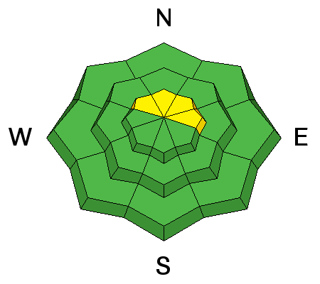
The primary avalanche concern for today is Thursday's storm snow sluffing, especially on steeper aspects in upper elevation terrain. These loose snow sluffs are likely, and although they won't involve much snow, they could take you for a ride in steeper terrain. Ski cuts are a very effective technique at mitigating this hazard. |
| type | aspect/elevation | characteristics |
|---|


|


|

LIKELIHOOD
 LIKELY
UNLIKELY
SIZE
 LARGE
SMALL
TREND
 INCREASING DANGER
SAME
DECREASING DANGER
|
|
description
In addition to sluffing in the loose storm snow, there are a few other avalanche concerns to watch for today:
We could use your help: There were few observations from Thursday, and from what we heard from the Salt Lake area mountains, the layer of surface hoar has seemingly been destroyed prior to Thursday's small storm, but the layer of faceted snow has been preserved underneath the new snow. I'm suspicious, and am expecting some surface hoar has been preserved in sheltered northerly terrain - particularly at the mid elevations - in the Salt Lake area mountains. (Indications from the Ogden area mountains are that this layer of surface hoar has been preserved underneath the storm snow.) With more snow and wind in the forecast, these buried weak layers could become reactive with additional loading. If you are getting out, dig your hand down in the top 6 - 8" of snow and let us know if you are finding these weak layers, particularly any surface hoar. The shovel tilt test is an especially useful tool for our current scenario. As always, we appreciate any observations we receive from the field.
|
 |
weather Temperatures will rise into the low to mid 30's at 8000', and 20's at 10,000'. Winds will remain light and will begin to increase about midday from the south. By late this afternoon, upper elevations will see gusts increase to about 30 mph. Today will be mostly cloudy, with a possible break midday allowing periods of sun before it clouds up again this afternoon. Snowfall is expected overnight, and storm totals of 5-10" in the Provo mountains are possible with this next storm. A brief break followed by yet another storm later on Sunday that lasts into at least early the coming week. |
general announcements
|