25th Annual Black Diamond Fall Fundraising Party
Thursday, September 13; 6:00-10:00 PM; Black Diamond Parking Lot
25th Annual Black Diamond Fall Fundraising Party
Thursday, September 13; 6:00-10:00 PM; Black Diamond Parking Lot
| Advisory: Provo Area Mountains | Issued by Greg Gagne for Friday - January 6, 2017 - 7:32am |
|---|

|
bottom line The avalanche hazard is Considerable at the upper elevations due to strong winds and storm snow from this past week. The two primary avalanche concerns are wind slabs and persistent slabs. At the lower and mid elevations the avalanche hazard is Moderate. Fortunately, cool temperatures, cloudy skies, and a storm that finished right-side up have provided brilliant ski and travel conditions on lower-angled terrain on all aspects. Travel advice for today is to give the snowpack at least another day to settle and adjust to this past week's wind and snow.
|
 |
special announcement The Salt Lake City premier of The Fourth Phase from the creators of The Art of Flight will at Brewvies at 7 pm on Monday, Jan 9 as a fundraiser for the Utah Avalanche Center. For tickets and details, go to https://utahavalanchecenter.org/event/fourth-phase UAC Skyline forecaster Brett Kobernik has a video describing the current snowpack for the Skyline, and avalanche concerns for Friday and Saturday: |
 |
current conditions As of 5 am, skies are clear and temperatures are in the negative single digits, with a few stations in the drainage bottoms at about -10 F. Winds are northerly and light, although some upper elevation stations are gusting into the low 20's mph. Storm snow in the central Wasatch from Wednesday and overnight into Thursday has settled to about a foot, and is right-side up with denser snow underneath the low-density snow at the surface. Skiing and travel conditions are superb. Week in Review The New Years holiday weekend featured clear skies and Low avalanche hazard. Beginning late Sunday night, a storm system came in that lasted through Tuesday morning. Storm totals in the Cottonwoods and Park City mountains were upwards of 2' with close to 2" of water (SWE). This low density snow fell on a preserved layer of near surface facets and surface hoar. Although there was one skier-triggered slide reported on Monday that failed on this layer, most avalanche activity through Tuesday was only sluffing within the storm snow as the low density snow was not acting as a cohesive slab. On Wednesday and Thursday the UAC issued an avalanche warning with the arrival of a storm system that brought dense snow and strong winds. The Ogden mountains northward received the brunt of the snowfall with over 2' of snow and widespread avalanche activity. The Cottonwoods and Park City mountains received 12-18". The Provo mountains received 29" with 4.5" of water, and went through a significant natural avalanche cycle on all aspects and elevations Wednesday and overnight into Thursday. There are several excellent observations from this past week that provide useful information as you prepare for your Friday and weekend plans. |
 |
recent activity No backcountry avalanches were reported from Thursday, although most backcountry travelers wisely stuck to conservative terrain. Control work produced avalanches within the storm snow from this past week, although a few were also triggered in wind slabs from Wednesday's strong westerly winds. Most of these slides were about a foot deep, although one Cottonwood resort reported some slides breaking down to 3'. The Provo mountains went through a significant avalanche cycle on Wednesday and overnight into Thursday. Below are two excellent observations submitted from Thursday: There was a close call with a skier-triggered slide on Hoyt Peak in the Uintas on Thursday. This occurred on a steep northeast aspect at 10000'. The party submitted an observation from this incident. We greatly appreciate all observations that we receive, especially those involving avalanches. |
| type | aspect/elevation | characteristics |
|---|

|
|
LIKELIHOOD
 LIKELY
UNLIKELY
SIZE
 LARGE
SMALL
TREND
 INCREASING DANGER
SAME
DECREASING DANGER
|
|
description
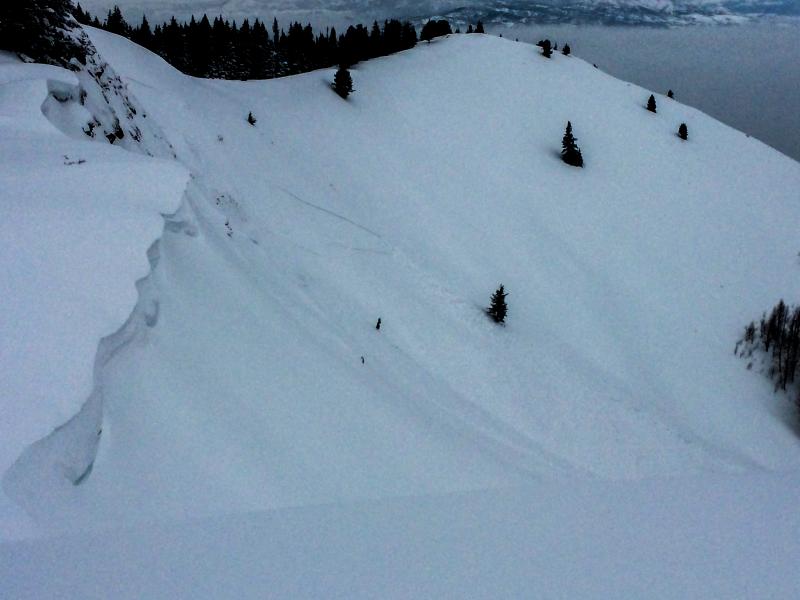
Strong westerly winds on Wednesday loaded many mid and upper elevation slopes on a variety of aspects, particularly at the upper elevations. On many of these slopes, these recent wind drifts are sitting on top of lower-density snow that fell from earlier this week, as well as a preserved layer of faceted snow that formed around the New Year. The photo below [Mletschnig] shows a natural avalanche that likely occurred overnight Wednesday. This occurred along the Park City ridgeline on a steep, wind-loaded east aspect at 9500'. Although most observers on Thursday noted these recent drifts to be unreactive to stability tests, my advice is to give it at least another day for the snowpack to adjust to this recent load.
|
| type | aspect/elevation | characteristics |
|---|

|

|
LIKELIHOOD
LIKELY
UNLIKELY
SIZE
LARGE
SMALL
TREND
INCREASING DANGER
SAME
DECREASING DANGER
|
|
description
There are several layers with persistent weaknesses in the upper 3-4' of the snowpack. Some of these layers formed during mid-December, as well as a layer of facets that formed over the New Year and was preserved underneath this week's storm snow. At some lower elevations, there are crust/facet combinations that are a cause for concern as well. (Trent has an excellent video from Monday illustrating this setup.) The concerns for a persistent slab are greater in outlying areas such as Lambs Canyon where there is a thinner, more-layered snowpack. On Monday pro observer Zinnia Wilson and Drew found this setup on Mt. Aire. The persistent slab issue is less of a concern in the Cottonwoods where the snowpack is deeper. Given the amounts of new snow and wind from this past week, my advice is to give it at least another day for these persistent layers in the snowpack to adjust to this recent load. |
 |
weather Sunny today with temperatures at the mid and upper elevations in the low to mid teens. Winds will be light and out of the north. Transition day on Saturday as things begin to get interesting again beginning late Saturday night with a period of warm, wet, and windy weather from an atmospheric river extending from Hawaii. The Provo mountains are forecasted to receive significant water amounts over the next 7-10 days. Aloha. |
general announcements
|