25th Annual Black Diamond Fall Fundraising Party
Thursday, September 13; 6:00-10:00 PM; Black Diamond Parking Lot
25th Annual Black Diamond Fall Fundraising Party
Thursday, September 13; 6:00-10:00 PM; Black Diamond Parking Lot
| Advisory: Provo Area Mountains | Issued by Trent Meisenheimer for Wednesday - January 4, 2017 - 7:35am |
|---|


|
bottom line The avalanche danger is CONSIDERABLE on all mid and upper elevation slopes, where wind slab, storm slab and persistent slab avalanches can be easily triggered. Expect the avalanche danger to be on the rise throughout the day, possibly reaching high danger by late this evening. Natural avalanches are possible at the upper elevations where the wind is blowing and drifting the snow. In some cases avalanches may be triggered from a distance Anyone heading into the backcountry needs good snowpack and terrain evaluation skills and conservative decision-making. Measure your slope angles and stay off of and out from under steep slopes, especially those getting wind drifted.
|
 |
avalanche watch THE FOREST SERVICE UTAH AVALANCHE CENTER IN SALT LAKE CITY HAS ISSUED A BACKCOUNTRY AVALANCHE WATCH. * TIMING…IN EFFECT FROM 6 AM MST THIS MORNING TO 6 AM MST THURSDAY * AFFECTED AREA…FOR THE MOUNTAINS OF NORTHERN UTAH INCLUDING THE WASATCH RANGE...UINTA MOUNTAINS...BEAR RIVER RANGE...BEAR LAKE AND FRANKLIN COUNTIES IN SE IDAHO... * AVALANCHE DANGER…THE AVALANCHE DANGER FOR THE WARNING AREA IS EXPECTED TO RISE DURING THE DAY. * IMPACTS…HEAVY SNOW COMBINED WITH WIND ARE CREATING WIDESPREAD AREAS OF UNSTABLE SNOW. BOTH HUMAN TRIGGERED AND NATURAL AVALANCHES ARE LIKELY. STAY OFF OF AND OUT FROM UNDER SLOPES STEEPER THAN 30 DEGREES. BACKCOUNTRY TRAVELERS SHOULD CONSULT WWW.UTAHAVALANCHECENTER.ORGOR CALL 1-888-999-4019 FOR MORE DETAILED INFORMATION. THIS WARNING DOES NOT APPLY TO SKI AREAS WHERE AVALANCHE HAZARD REDUCTION MEASURES ARE PERFORMED. |
 |
special announcement The Salt Lake City premier of The Fourth Phase from the creators of The Art of Flight will at Brewvies at 7 pm on Monday, Jan 9 as a fundraiser for the Utah Avalanche Center. For tickets and details, go to https://utahavalanchecenter.org/event/fourth-phase |
 |
current conditions The first few snow flakes of the new storm are starting to fall this morning. Unfortunately, the west winds are ruining the powder party with speeds of 30-40 mph gusting to 92 mph at 11,000 feet in elevation. The 10,000' ridge lines are blowing in the 20-25 mph range gusting into the 50's. Mountain temperatures are slightly warmer this morning, with trailhead temperatures in the mid to low 20's and upper elevations temperatures are in the mid to upper teens. Video of Craig Gordon explaining why the storm is going to increase the avalanche danger. |
 |
recent activity Most of the avalanche activity reported yesterday was confined to the new snow. Fast moving sluffs and loose snow avalanches were reported by many backcountry parties as well as control teams. No slab avalanches were reported from the backcountry yesterday. However, I think today will be a game changer. Check out the observation page found here. |
| type | aspect/elevation | characteristics |
|---|

|
|
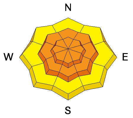
LIKELIHOOD
 LIKELY
UNLIKELY
SIZE
 LARGE
SMALL
TREND
 INCREASING DANGER
SAME
DECREASING DANGER
|
|
description
Wind speeds have already increased from Ogden to Provo. With plenty of light snow available for transport and upper elevation wind speeds fast enough to drift the snow, sensitive wind slabs will be found in the higher terrain. Anywhere, anytime the wind speeds increase, natural avalanches will be possible, and human triggered slides certain on wind-drifted slopes. Avoid travel on and below wind-drifted slopes. The drifts will be most widespread at the upper elevations, but evaluate mid elevation terrain carefully, too, for any signs of wind drifting. See the wind speeds below from a weather station at 10,500 feet in Little Cottonwood Canyon which is representative of increased winds in other places.
|
| type | aspect/elevation | characteristics |
|---|

|

|
LIKELIHOOD
 LIKELY
UNLIKELY
SIZE
 LARGE
SMALL
TREND
INCREASING DANGER
SAME
DECREASING DANGER
|
|
description
Warm, heavy snow will change the game today. We are expecting 5-9" of dense snow with more coming tonight. Dense, heavy snow on top of light fluffy snow is a good recipe for avalanches. |
| type | aspect/elevation | characteristics |
|---|

|
|
LIKELIHOOD
 LIKELY
UNLIKELY
SIZE
LARGE
SMALL
TREND
INCREASING DANGER
SAME
DECREASING DANGER
|
|
description
The snowpack has a variety of buried facets and crusts on mid and upper elevation slopes of all aspects, with the newest layer of facets just buried two days ago. A smaller storm snow slide might be able to trigger a deeper slide in the snowpack, especially in a shallower snowpack area. Be especially wary of slopes that have slid one or more times this year, drainages with less snow, and wind scoured areas. Video animation of a slab avalanche. |
 |
weather Expect 3-7" of new snow throughout the day with increasing densities. Winds will be increasing from the west today with 10,000' elevations averaging 20-30 mph gusting into the 50's. Temperatures will warm slightly and the rain snow line will hover around the foothills this morning and will drop to the valley floor this evening once the storm shifts to a more northerly flow. The strongest part of the storm will be in the overnight hours lingering into tomorrow morning. 15-20 inches of new snow by Friday is a good bet. |
general announcements
|


