| Please join us at the 23rd annual Black Diamond Fall Fundraiser Party Thursday Sept 15. Tickets are on sale now here, at the Black Diamond store & at REI. Special bonus raffle for online ticket purchasers! |
| Please join us at the 23rd annual Black Diamond Fall Fundraiser Party Thursday Sept 15. Tickets are on sale now here, at the Black Diamond store & at REI. Special bonus raffle for online ticket purchasers! |
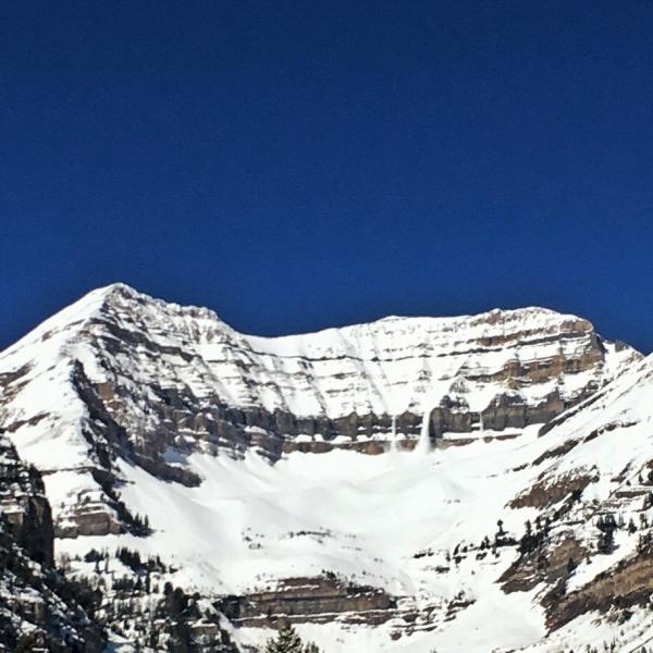
| Advisory: Provo Area Mountains | Issued by Drew Hardesty for Sunday - April 3, 2016 - 6:14am |
|---|

|
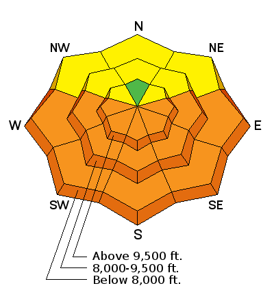
bottom line A LOW avalanche danger will rise to MODERATE and then CONSIDERABLE with daytime heating. The rapid rise of avalanche danger will start on the east, then south, then westerly facing aspects...with all but high north getting into the game by midday. Early starts and early exits are key this time of year. You're asking for trouble if you are in or below the steepest sunlit aspects after the snow has become unsupportable. Cornices may calve with the heating today.
|
 |
current conditions Skies are clear. Winds remain generally light from the west. Overnight lows as of 4am are in the upper 30s to low 40s, but I imagine a few more hours under clear skies should help help these elevations trend toward at least a superficial refreeze. Upper elevation northerlies hold cold, if variable, conditions. |
 |
recent activity Wet loose naturalling continued like clockwork yesterday with a few observations coming in across the range. (Pic: Jake Hutchinson) Also, of interest, I was able to look at the GoPro footage of the incident on Monte Cristo from Friday and the debris looked less like wet loose snow and more like bits of fallen cornice.
|
| type | aspect/elevation | characteristics |
|---|

|

|
LIKELIHOOD
 LIKELY
UNLIKELY
SIZE
 LARGE
SMALL
TREND
 INCREASING DANGER
SAME
DECREASING DANGER
|
|
description
The greatest concern for today continues to be heat-related activity. Despite a decent refreeze due to clear skies, overnight lows are in the "marginal" range and and the snow will soften and become unsupportable and unstable earlier today. When you start to see pinwheels, small natural wet slides, or you start to gouge in the wet slop with your skis or machine, it's time to head to a cooler aspect and low angle terrain. As the cold early week storm snow transitions with the heating, the sluffs may pry out a few wet slab avalanches as well. I consider these conditions to be a time and place thing. If you're in steep sun-drenched terrain in the mid-afternoon, it's likely you'll be moving wet snow down the hillside. Remember that while wet sluffs move more slowly than dry avalanches, you'll want to avoid getting tripped up in the slow moving concrete, especially in confined terrain. Note: Pay attention for wet activity in mid to low elevation north aspects, particularly during the afternoon hours. As always, you can click on the 'i' next to the infographic above for more information and travel advice. |
 |
weather We'll have clear skies, light westerly wind, and daytime highs at 10,000' and 8000' in the upper 30s and mid 50s, respectively. May see a few clouds in the afternoon with a weak storm Monday night into Tuesday that'll bring cooler temps and perhaps a trace to an inch. High pressure rebounds for mid-week with unsettled weather moving in Friday into the weekend. |
| general announcements Remember your information can save lives. If you see anything we should know about, please help us out by submitting snow and avalanche conditions. You can also call us at 801-524-5304, email by clicking HERE, or include #utavy in your tweet or Instagram. To get help in an emergency (to request a rescue) in the Wasatch, call 911. Be prepared to give your GPS coordinates or the run name. Dispatchers have a copy of the Wasatch Backcountry Ski map. Backcountry Emergencies. It outlines your step-by-step method in the event of a winter backcountry incident. If you trigger an avalanche in the backcountry, but no one is hurt and you do not need assistance, please notify the nearest ski area dispatch to avoid a needless response by rescue teams. Thanks.
EMAIL ADVISORY If you would like to get the daily advisory by email you will need to subscribe here. DAWN PATROL Hotline updated daily by 5-530am - 888-999-4019 option 8. TWITTER Updates for your mobile phone - DETAILS UDOT canyon closures: LINK TO UDOT, or on Twitter, follow @UDOTavy, @CanyonAlerts or @AltaCentral Utah Avalanche Center mobile app - Get your advisory on your iPhone along with great navigation and rescue tools. Powderbird Helicopter Skiing - Blog/itinerary for the day Lost or Found something in the backcountry? - http://nolofo.com/ To those skinning uphill at resorts: it is critical to know the resort policy on uphill travel. You can see the uphill travel policy for each resort here. Benefit the Utah Avalanche Center when you shop from Backcountry.com or REI: Click this link for Backcountry.com or this link to REI, shop, and they will donate a percent of your purchase price to the UAC. Both offer free shipping (with some conditions) so this costs you nothing! Benefit the Utah Avalanche Center when you buy or sell on ebay - set the Utah Avalanche Center as a favorite non-profit in your ebay account here and click on ebay gives when you buy or sell. You can choose to have your seller fees donated to the UAC, which doesn't cost you a penny. This information does not apply to developed ski areas or highways where avalanche control is normally done. This advisory is from the U.S.D.A. Forest Service, which is solely responsible for its content. This advisory describes general avalanche conditions and local variations always exist. |