| Please join us at the 23rd annual Black Diamond Fall Fundraiser Party Thursday Sept 15. Tickets are on sale now here, at the Black Diamond store & at REI. Special bonus raffle for online ticket purchasers! |
| Please join us at the 23rd annual Black Diamond Fall Fundraiser Party Thursday Sept 15. Tickets are on sale now here, at the Black Diamond store & at REI. Special bonus raffle for online ticket purchasers! |
| Advisory: Provo Area Mountains | Issued by Drew Hardesty for Saturday - April 2, 2016 - 7:13am |
|---|


|
bottom line A LOW avalanche danger will rise to MODERATE and then CONSIDERABLE with daytime heating. The rapid rise of avalanche danger will start on the east, then south, then westerly facing aspects...with all but high north getting into the game by midday. Early starts and early exits are key this time of year. You're asking for trouble if you are in or below the steepest sunlit aspects after the snow has become unsupportable. Cornices may calve with the heating today.
|
 |
special announcement Thanks for all the generous donations from the Love Utah/Give Utah fundraising event towards the Utah Avalanche Center. Your donations help us with issuing avalanche advisories, outreach, and education. All part of our mission to keep you on top of the greatest snow on earth! |
 |
current conditions Skies are clear. Temps are generally in the upper 20s to low 30s (roughly 5-10° warmer than they were last night); winds are hardly a whisper. All but high north will have a zipper to breakable crust this morning that will soften with daytime heating. Review of Snow and Weather from this past week (via Greg Gagne): On Monday, a storm moved in to the region, with high precipitation rates and a south/southeast wind leading to sensitive avalanche conditions as well as some natural avalanche activity on Monday and especially early Tuesday. The primary weak layer was the new snow/storm snow interface. The S/SE flow (unusual for us) put down the greatest snow amounts in the mountains east of the mountain valleys. By Wednesday, conditions had mostly stabilized and we've transitioned to more wet avalanche problems. |
 |
recent activity
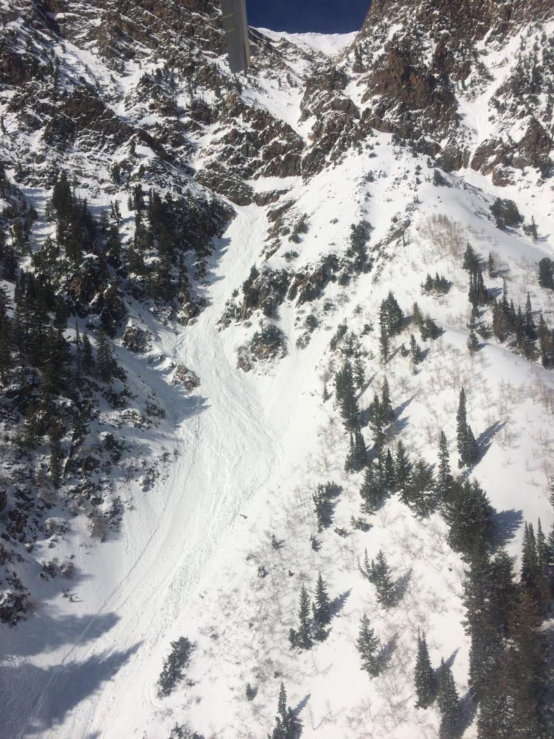
Wet loose activity was noted in many steep sunlit aspect with enough debris to bury a person with thunderous waterfall wet debris reportedly running in Primrose Cirque above Aspen Grove. We expect more for today. There was a very close call in the Monte Cristo gulley yesterday at about 11am. (Monte Cristo is just west of Superior on the Cottonwood ridgeline above Little Cottonwood Canyon.) Two snowboarders descended Monte Cristo Direct at 1030am. At the choke, Person A successfully rappelled down and waited for Person B to join him below. At that point, a wet loose slide cascaded down upon them from above, pummeling Person B who was on rappel while catching and then carrying Person A over two minor cliffbands. It is not known whether the person on rappel was clipped into the anchor or backed up with an autoblock above or below his rappel device. It is also not known whether the loose sluff was a natural or triggered from above. One can only imagine the sound of a waterfall coming down from above while in such radical terrain. After the avalanche, both were able to make it down to the road unassisted. (Aerial photo below of Monte Cristo yesterday courtesy Powderbird)
|
| type | aspect/elevation | characteristics |
|---|

|

|
LIKELIHOOD
 LIKELY
UNLIKELY
SIZE
 LARGE
SMALL
TREND
 INCREASING DANGER
SAME
DECREASING DANGER
|
|
description
The greatest concern for today continues to be heat-related activity. Yesterday had the benefit of cooler starting and overall temps and a touch of northerly wind; however today won't have such luck. Despite a decent refreeze due to clear skies and below freezing temps, the snow will soften and become unsupportable and unstable earlier today. When you start to see pinwheels, small natural wet slides, or you start to gouge in the wet slop with your skis or machine, it's time to head to a cooler aspect and low angle terrain. As the cold early week storm snow transitions with the heating, the sluffs may pry out a few wet slab avalanches as well. Note: Pay attention for wet activity in mid to low elevation north aspects, particularly during the afternoon hours. As always, you can click on the 'i' next to the infographic above for more information and travel advice. |
 |
weather We'll have clear skies, light westerly wind, and daytime highs at 10,000' and 8000' in the mid 30s and low 50s, respectively. May see a few more clouds tomorrow with a weak storm Monday/Tuesday. High pressure rebounds for mid-week with perhaps a mirage of a storm on the horizon for next weekend. |
| general announcements Remember your information can save lives. If you see anything we should know about, please help us out by submitting snow and avalanche conditions. You can also call us at 801-524-5304, email by clicking HERE, or include #utavy in your tweet or Instagram. To get help in an emergency (to request a rescue) in the Wasatch, call 911. Be prepared to give your GPS coordinates or the run name. Dispatchers have a copy of the Wasatch Backcountry Ski map. Backcountry Emergencies. It outlines your step-by-step method in the event of a winter backcountry incident. If you trigger an avalanche in the backcountry, but no one is hurt and you do not need assistance, please notify the nearest ski area dispatch to avoid a needless response by rescue teams. Thanks.
EMAIL ADVISORY If you would like to get the daily advisory by email you will need to subscribe here. DAWN PATROL Hotline updated daily by 5-530am - 888-999-4019 option 8. TWITTER Updates for your mobile phone - DETAILS UDOT canyon closures: LINK TO UDOT, or on Twitter, follow @UDOTavy, @CanyonAlerts or @AltaCentral Utah Avalanche Center mobile app - Get your advisory on your iPhone along with great navigation and rescue tools. Powderbird Helicopter Skiing - Blog/itinerary for the day Lost or Found something in the backcountry? - http://nolofo.com/ To those skinning uphill at resorts: it is critical to know the resort policy on uphill travel. You can see the uphill travel policy for each resort here. Benefit the Utah Avalanche Center when you shop from Backcountry.com or REI: Click this link for Backcountry.com or this link to REI, shop, and they will donate a percent of your purchase price to the UAC. Both offer free shipping (with some conditions) so this costs you nothing! Benefit the Utah Avalanche Center when you buy or sell on ebay - set the Utah Avalanche Center as a favorite non-profit in your ebay account here and click on ebay gives when you buy or sell. You can choose to have your seller fees donated to the UAC, which doesn't cost you a penny. This information does not apply to developed ski areas or highways where avalanche control is normally done. This advisory is from the U.S.D.A. Forest Service, which is solely responsible for its content. This advisory describes general avalanche conditions and local variations always exist. |