| Please join us at the 23rd annual Black Diamond Fall Fundraiser Party Thursday Sept 15. Tickets are on sale now here, at the Black Diamond store & at REI. Special bonus raffle for online ticket purchasers! |
| Please join us at the 23rd annual Black Diamond Fall Fundraiser Party Thursday Sept 15. Tickets are on sale now here, at the Black Diamond store & at REI. Special bonus raffle for online ticket purchasers! |
| Advisory: Provo Area Mountains | Issued by Evelyn Lees for Thursday - March 10, 2016 - 6:34am |
|---|


|
bottom line The avalanche danger is generally LOW early this morning, though wind drifts can still be triggered on upper elevation slopes facing north through east. The avalanche danger will increase to MODERATE with heating today – wet loose sluffs will be easy to trigger, and natural slides are possible. Avoid travel on and below steep sunny slopes once the snow heats up.
|
 |
special announcement Thursday 6pm: Utah Adventure Journals final installment of the speaker series with Ted and Jenny Wilson at Snowbird presented by Scarpa. Raffle held to benefit UAC. Must be 21 or older to attend. DETAILS HERE!
The Utah Avalanche Center greatly values our longtime partnership with our world-class resorts and is blowing out the remaining donated lift tickets from Snowbird, Snowbasin, Sundance, and Nordic Valley with reduced prices. Every penny you spend benefits the Utah Avalanche Center. |
 |
current conditions Under partly cloudy skies, temperatures are warming, and are now close to freezing at most mid elevation Provo mountain stations, and probably in the mid 20s at the upper elevations. Winds have shifted to the southwest and are light, averaging 10 to 15 mph. Yesterday’s “mini” storm dropped about 1 to 4" of snow in the Provo area mountains. Today, the crusty sunny slopes will rapidly soften; with powder remaining on upper elevation northerly facing slopes. |
 |
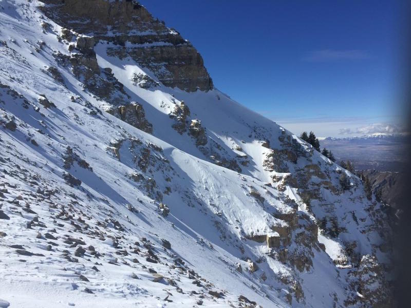
recent activity Yesterday morning, upper elevation winds kicked up, lasting through early afternoon and drifting the snow. Soft wind slabs were triggered on the north peak of Timpanogos, Hogum Hogback, and in Bells – longer running in continuous steep terrain. This activity was above 10,000’ on east and northeast facing slopes. Resort avalanche reduction workers also triggered small new snow wind slabs and cornices with ski cuts and explosives, again at upper elevations.
Photos from north peak of Timp: Caroline Gleich. Left photo: crown in center on subridge Right photo: wind drifting snow
|
| type | aspect/elevation | characteristics |
|---|

|
|
LIKELIHOOD
 LIKELY
UNLIKELY
SIZE
 LARGE
SMALL
TREND
 INCREASING DANGER
SAME
DECREASING DANGER
|
|
description
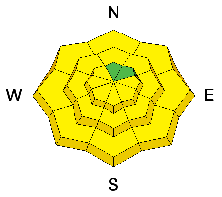
Clear skies, strong sun and a big jump in temperatures make wet snow avalanches the primary concern today. While the danger is low early this morning, it will rapidly rise as the day heats up. Wet loose sluffs will be easy to trigger on steep, sunny slopes – first east, then south, then west – and on low and mid elevation northerly facing slopes. Natural avalanches may occur on the steepest sunny slopes. Though initially shallow, these wet loose sluffs could build up significant debris piles at the bottoms of steep gullies or in terrain traps like creek bottoms.
|
| type | aspect/elevation | characteristics |
|---|

|
|
LIKELIHOOD
 LIKELY
UNLIKELY
SIZE
LARGE
SMALL
TREND
 INCREASING DANGER
SAME
DECREASING DANGER
|
|
description
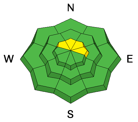
It will still be possible to trigger a few wind slabs along the high ridges today - above about 10,000', on north through easterly facing slopes. While most of these are not large enough to bury you, they will definitely catch and carry you, and a rough through rocks or a long ride could result in injuries. In addition, both cornices and dry loose sluffs can be triggered. |
 |
weather It is going to be down right hot today – temperatures will soar into the mid to upper 30s at 10,000’, and mid 50s at 8,000’. The southwesterly winds will be light this morning, but along the highest ridges and peaks speeds will increase into the 15 to 25 mph range this afternoon, with gusts in the 30s. Friday will again be hot, but windier and with variable high thin clouds. Cooler temperatures and snow are in the forecast for late in the weekend through much of next week. |
| general announcements Remember your information can save lives. If you see anything we should know about, please help us out by submitting snow and avalanche conditions. You can also call us at 801-524-5304, email by clicking HERE, or include #utavy in your tweet or Instagram. To get help in an emergency (to request a rescue) in the Wasatch, call 911. Be prepared to give your GPS coordinates or the run name. Dispatchers have a copy of the Wasatch Backcountry Ski map. Backcountry Emergencies. It outlines your step-by-step method in the event of a winter backcountry incident. If you trigger an avalanche in the backcountry, but no one is hurt and you do not need assistance, please notify the nearest ski area dispatch to avoid a needless response by rescue teams. Thanks.
EMAIL ADVISORY If you would like to get the daily advisory by email you will need to subscribe here. DAWN PATROL Hotline updated daily by 5-530am - 888-999-4019 option 8. TWITTER Updates for your mobile phone - DETAILS UDOT canyon closures: LINK TO UDOT, or on Twitter, follow @UDOTavy, @CanyonAlerts or @AltaCentral Utah Avalanche Center mobile app - Get your advisory on your iPhone along with great navigation and rescue tools. Powderbird Helicopter Skiing - Blog/itinerary for the day Lost or Found something in the backcountry? - http://nolofo.com/ To those skinning uphill at resorts: it is critical to know the resort policy on uphill travel. You can see the uphill travel policy for each resort here. Benefit the Utah Avalanche Center when you shop from Backcountry.com or REI: Click this link for Backcountry.com or this link to REI, shop, and they will donate a percent of your purchase price to the UAC. Both offer free shipping (with some conditions) so this costs you nothing! Benefit the Utah Avalanche Center when you buy or sell on ebay - set the Utah Avalanche Center as a favorite non-profit in your ebay account here and click on ebay gives when you buy or sell. You can choose to have your seller fees donated to the UAC, which doesn't cost you a penny. This information does not apply to developed ski areas or highways where avalanche control is normally done. This advisory is from the U.S.D.A. Forest Service, which is solely responsible for its content. This advisory describes general avalanche conditions and local variations always exist. |