| Please join us at the 23rd annual Black Diamond Fall Fundraiser Party Thursday Sept 15. Tickets are on sale now here, at the Black Diamond store & at REI. Special bonus raffle for online ticket purchasers! |
| Please join us at the 23rd annual Black Diamond Fall Fundraiser Party Thursday Sept 15. Tickets are on sale now here, at the Black Diamond store & at REI. Special bonus raffle for online ticket purchasers! |
| Advisory: Provo Area Mountains | Issued by Drew Hardesty for Tuesday - March 8, 2016 - 6:33am |
|---|

|
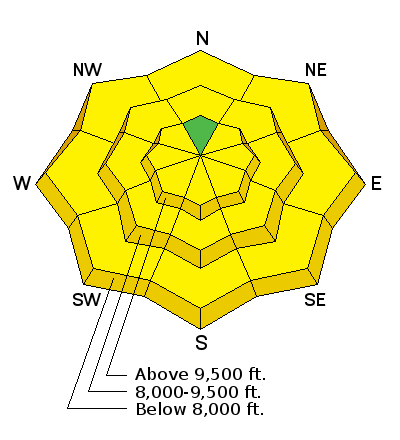
bottom line We have a mostly LOW danger this morning. Within a few hours, the danger will rise to MODERATE with sun and daytime heating. This includes all elevations and aspects but high north. Any wet sluffs triggered in the low to mid elevation sheltered aspects may gouge more deeply in the poorly consolidated snowpack, producing a larger debris pile. Remember that risk is always inherent in mountain travel and terrain choices may amplify the consequences of even a minor avalanche.
|
 |
special announcement The Utah Avalanche Center greatly values our longtime partnership with our world-class resorts and is blowing out the remaining donated lift tickets from Snowbird, Snowbasin, Sundance, and Nordic Valley with reduced prices. Every penny you spend benefits the Utah Avalanche Center. Check out our Garage Sale! Chock full of sweet backcountry gear - you can find the goods on our Facebook page here. |
 |
current conditions Clear skies, light wind, temps in the upper teens to low 20s. Many of yesterday's sun-kissed aspects will be crusted this morning but will soften with daytime heating. |
 |
recent activity Wet and dry sluffing along with a few minor wind pockets compromise yesterday's avalanche activity. |
| type | aspect/elevation | characteristics |
|---|

|
|
LIKELIHOOD
 LIKELY
UNLIKELY
SIZE
 LARGE
SMALL
TREND
 INCREASING DANGER
SAME
DECREASING DANGER
|
|
description
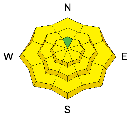
It's getting to be that time of year. Rapid warming and a sun high in the sky tends to affect all but the high northerlies. It's a timing thing. Too early and it'll be breakable; too late and you've overstayed your welcome. If you're seeing pin-wheels, push-a-lanches, or natural sluffs, move to lower angle terrain or a cooler aspect. For the northerly terrain below 8500' - While the clear skies and much cooler temps no doubt locked up the surface snow, I have my doubts that the lock-up penetrated all through the snowpack. In other words, I can imagine that by midday into the afternoon, any sluff triggered may gouge more deeply into the snowpack in the sheltered low to mid-elevations. Mind the terrain traps in these elevations by midday into the early afternoon. |
| type | aspect/elevation | characteristics |
|---|

|
|
LIKELIHOOD
 LIKELY
UNLIKELY
SIZE
 LARGE
SMALL
TREND
 INCREASING DANGER
SAME
DECREASING DANGER
|
|
description
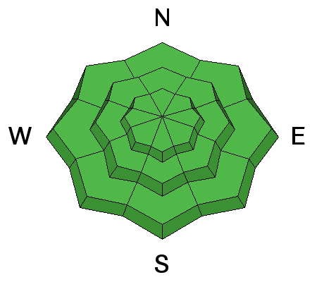
This category accounts for the rest of the grab-bag avalanche concerns -
|
 |
weather We'll have clear skies this morning with daytime highs in the low to mid-20s at 10k; the upper 30s at 8000'. Increasing clouds by midday into the afternoon are little more than a teaser of a weak storm passing by to the north. It may be possible to squeeze a trace to an inch out of the thing into tomorrow morning. Otherwise, we'll have mostly cloudy to overcast skies, light wind, and slightly cooler temps for tomorrow. A warm front follows for late Wednesday into early Thursday with possible riming and slightly gustier winds. Ridgetop temps rise to the mid to upper 30s by Thursday afternoon. Increasing southwest winds Friday portend a minor disturbance for Saturday. The models continue to forecast stormy conditions into early next week. |
| general announcements Remember your information can save lives. If you see anything we should know about, please help us out by submitting snow and avalanche conditions. You can also call us at 801-524-5304, email by clicking HERE, or include #utavy in your tweet or Instagram. To get help in an emergency (to request a rescue) in the Wasatch, call 911. Be prepared to give your GPS coordinates or the run name. Dispatchers have a copy of the Wasatch Backcountry Ski map. Backcountry Emergencies. It outlines your step-by-step method in the event of a winter backcountry incident. If you trigger an avalanche in the backcountry, but no one is hurt and you do not need assistance, please notify the nearest ski area dispatch to avoid a needless response by rescue teams. Thanks.
EMAIL ADVISORY If you would like to get the daily advisory by email you will need to subscribe here. DAWN PATROL Hotline updated daily by 5-530am - 888-999-4019 option 8. TWITTER Updates for your mobile phone - DETAILS UDOT canyon closures: LINK TO UDOT, or on Twitter, follow @UDOTavy, @CanyonAlerts or @AltaCentral Utah Avalanche Center mobile app - Get your advisory on your iPhone along with great navigation and rescue tools. Powderbird Helicopter Skiing - Blog/itinerary for the day Lost or Found something in the backcountry? - http://nolofo.com/ To those skinning uphill at resorts: it is critical to know the resort policy on uphill travel. You can see the uphill travel policy for each resort here. Benefit the Utah Avalanche Center when you shop from Backcountry.com or REI: Click this link for Backcountry.com or this link to REI, shop, and they will donate a percent of your purchase price to the UAC. Both offer free shipping (with some conditions) so this costs you nothing! Benefit the Utah Avalanche Center when you buy or sell on ebay - set the Utah Avalanche Center as a favorite non-profit in your ebay account here and click on ebay gives when you buy or sell. You can choose to have your seller fees donated to the UAC, which doesn't cost you a penny. This information does not apply to developed ski areas or highways where avalanche control is normally done. This advisory is from the U.S.D.A. Forest Service, which is solely responsible for its content. This advisory describes general avalanche conditions and local variations always exist. |