| Please join us at the 23rd annual Black Diamond Fall Fundraiser Party Thursday Sept 15. Tickets are on sale now here, at the Black Diamond store & at REI. Special bonus raffle for online ticket purchasers! |
| Please join us at the 23rd annual Black Diamond Fall Fundraiser Party Thursday Sept 15. Tickets are on sale now here, at the Black Diamond store & at REI. Special bonus raffle for online ticket purchasers! |
| Advisory: Provo Area Mountains | Issued by Greg Gagne for Friday - February 12, 2016 - 7:23am |
|---|

|
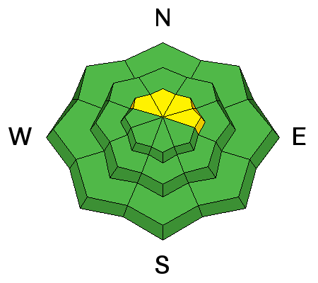
bottom line The avalanche danger is mostly LOW this morning. A MODERATE danger remains at high elevations due to the chance of a deep slab avalanche. Additionally, the danger will rise to MODERATE on south aspects due to a loose wet snow avalanche problem as things warm up during the heat of the day.
|
 |
special announcement Tuesday, February 16th - Companion Rescue Clinic at Weller Recreation from 6:30-9pm. For more info HERE. |
 |
current conditions It's a warm morning with many mid to upper elevation weather stations reporting above freezing temperatures. Stations in canyon bottoms are reporting below freezing temps, so a temperature inversion is in place as is often the case during periods of high pressure. I do think there has been enough cooling of the snow surface from clear skies to help provide a decent refreeze of the snow surface surface, but it is likely to soften quickly this morning as temperatures warm. Winds have been light and mostly from the west. There have been several observations from this past week reporting a weakening snow surface on mid and upper elevation north facing slopes. This includes near-surface facets as well as surface hoar. For the time being this is not a concern, but it is something we will need to pay attention to once we receive a new load of snow and/or wind loading.
|
 |
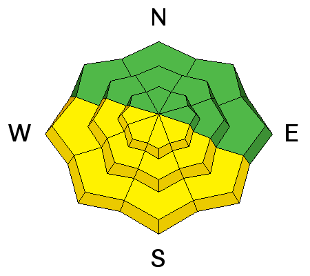
recent activity There was minimal wet loose avalanche activity yesterday on steeper south and west aspects. |
| type | aspect/elevation | characteristics |
|---|

|
|
LIKELIHOOD
 LIKELY
UNLIKELY
SIZE
 LARGE
SMALL
TREND
 INCREASING DANGER
SAME
DECREASING DANGER
|
|
description
Overall it seems the majority of wet activity occurred earlier this week, and only minor wet sluffing has been reported the past few days. I received one report from yesterday indicating south aspects softening about 11 am. Although skies were clear, overnight lows are a bit warmer than Wednesday night and the snow may soften earlier this morning. Watch for signs of instability such as pinwheels and rollerballs. It's time to get off of - and out from underneath - the snow surface once it becomes sloppy and over your boot tops. Bruce Tremper provided a great video overview of the snowpack on sunny aspects. |
| type | aspect/elevation | characteristics |
|---|

|
|
LIKELIHOOD
 LIKELY
UNLIKELY
SIZE
 LARGE
SMALL
TREND
 INCREASING DANGER
SAME
DECREASING DANGER
|
|
description
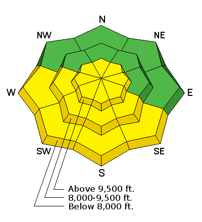
We haven't had a reported avalanche that failed in old snow since February 2, and it has been over 2 weeks since we have had a period of any widespread avalanche activity. Many steep, upper elevation slopes in the central Wasatch are filled with tracks. However we are still talking about the possibility of deep and persistent slab avalanches. The likelihood of triggering one of these is quite low, but the consequences remain high as such a slide would step down to the ground and rocks. This terrain is confined to steep upper elevation aspects facing northwest through east, especially on slopes that have a shallower snowpack (3-4 feet) as well as slopes that have already avalanched. |
 |
weather Temperatures today should reach the mid 40s F with light Westerly winds. Occasional high clouds may stream overhead. Increasing clouds are expected over the weekend with the possibility of a few inches of snow on Sunday. Stay tuned. |
general announcements
|