| Please join us at the 23rd annual Black Diamond Fall Fundraiser Party Thursday Sept 15. Tickets are on sale now here, at the Black Diamond store & at REI. Special bonus raffle for online ticket purchasers! |
| Please join us at the 23rd annual Black Diamond Fall Fundraiser Party Thursday Sept 15. Tickets are on sale now here, at the Black Diamond store & at REI. Special bonus raffle for online ticket purchasers! |
| Advisory: Provo Area Mountains | Issued by Evelyn Lees for Saturday - January 30, 2016 - 6:50am |
|---|


|
bottom line An Avalanche Warning has been issued for all the mountains of northern Utah. The Avalanche Danger is increase to HIGH today on and below all upper and mid elevation slopes steeper than about 30 degrees. Natural avalanches are probable today; avalanche run out zones should be avoided.
CONSIDERABLE Avalanche Danger on low elevation slopes, where wet snow avalanches could be triggered. Avoid steep slopes and terrain traps like gullies, road banks and creek bottoms.
Many of the Utah ice climbs are in avalanche paths, below starting zones that could get heavily loaded with snow today.
|
 |
avalanche warning An Avalanche Warning has been issued for all the mountains of northern Utah. The avalanche danger will increase to HIGH today as snow and wind continue. Dangerous avalanche conditions exist at all elevations, including low elevations where rain has fallen on snow. Travel in backcountry avalanche terrain and run out zones is not recommended. |
 |
special announcement Utah’s world class resorts, where avalanche reduction work is done, are a safer option for these high danger days. Plan for the future, and order you Lift Tickets here… these generous donations by Utah resorts allow all the proceeds to go to the Utah Avalanche Center.
There are still spaces in the Women’s Backcountry 101 avalanche classes at Brighton and Snowbasin. For more info on those classes and other education offerings through out the state, check out our Education Page. |
 |
current conditions We are punishing our snow pack – rain overnight to about 7,500 feet, and is still falling at the lower elevations of the Provo area mountians. Strong 20 to 30 mph southwesterly winds blew overnight at the mid elevations, and now a cold front marching in. Overnight, snow totals are a very dense 2-3” at the upper elevations, with water content near 3/4" of an inch in many spots - a combination of rain and snow. Temperatures are slowly dropping, though the low elevations are still in the mid 30s, the upper elevations now below freezing. Winds are shifting to the west-northwest. |
 |
recent activity Sluffing and small wind slabs of the Thursday night snow was reported in Ogden area mountains and minor wet snow sluffs occurred throughout the range. |
| type | aspect/elevation | characteristics |
|---|

|

|
LIKELIHOOD
 LIKELY
UNLIKELY
SIZE
 LARGE
SMALL
TREND
 INCREASING DANGER
SAME
DECREASING DANGER
|
|
description
The most widespread avalanche activity today will be new snow avalanches. Still several hours away, during periods of heavy snowfall, natural avalanches could occur, especially on wind drifted slopes. The weak surface snow may not have been destroyed on all shady slopes and is “Guilty until proven innocent”. Cracking, collapsing, failure on small test slopes or the remote triggering of small slides are clues to dangerous new snow instability. A shovel tilt test is also a good way to check for the weak layers in the upper snow pack.
On the south ½ of the compass, there may be poor bonding to some of the slick crusts on the sunny slopes. Once slides start moving, they could be long running on these aspects with the good bed surface. |
| type | aspect/elevation | characteristics |
|---|

|

|
LIKELIHOOD
 LIKELY
UNLIKELY
SIZE
LARGE
SMALL
TREND
INCREASING DANGER
SAME
DECREASING DANGER
|
|
description
The largest, most dangerous avalanches today will be slides breaking on one of our more deeply buried faceted weak layers. We will continue to overload them today with additional snow, especially on wind-drifted slopes. These deep, long running avalanches won’t be on every slope, but unsurvivable where they run. They could surprise you by dumping deep debris on to trails and slopes from starting zones far above. Prime candidates are slopes with a shallow snow pack, especially slopes that have previously slid one or more times this year |
| type | aspect/elevation | characteristics |
|---|

|

|
LIKELIHOOD
LIKELY
UNLIKELY
SIZE
 LARGE
SMALL
TREND
 INCREASING DANGER
SAME
DECREASING DANGER
|
|
description
Snow never takes fondly to rain, and the wet glop at the low to mid elevation should sluff readily today on steep slopes, especially with a push. Avoid steep slopes at low to mid elevation, especially terrain traps where the cement like debris will pile up deeply.
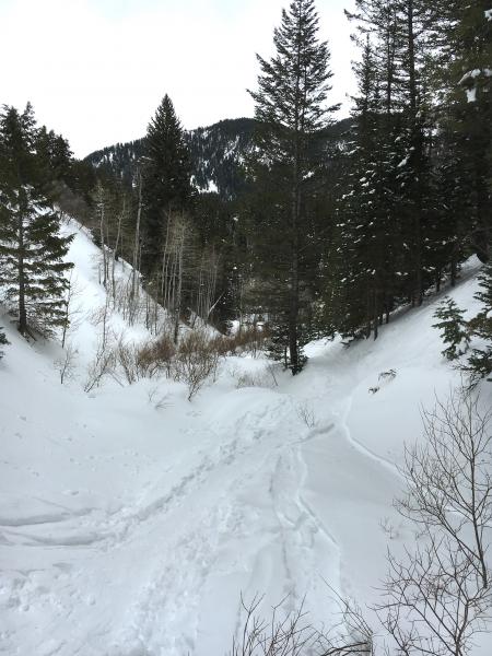
Left: example of a terrain trap Right: Larger terrain trap, and also a potential "avalanche run out zone"
|
 |
weather A strong cold front is marching southeast across northern Utah, with the heaviest snowfall in the Wasatch mountains expected from mid morning through early afternoon, with peak rates of 1 to 2” an hour. The front may take til noon to reach the Provo area mountains. Until then, warm temperatures will allow rain to continue. Winds are shifting to the west northwest and could average 25 mph, with gusts in the 30s through the afternoon. Speeds across the high ridgelines could once again average 45 mph, with gusts in the 70s. 10,000’ temperatures will plummet, to near 10 by evening |
| general announcements Remember your information can save lives. If you see anything we should know about, please participate in the creation of our own community avalanche advisory by submitting snow and avalanche conditions. You can also call us at 801-524-5304, email by clicking HERE, or include #utavy in your tweet or Instagram. To get help in an emergency (to launch a rescue) in the Wasatch, call 911. Be prepared to give your GPS coordinates or the run name. Dispatchers have a copy of the Wasatch Backcountry Ski map. Backcountry Emergencies. It outlines your step-by-step method in the event of a winter backcountry incident. If you trigger an avalanche in the backcountry, but no one is hurt and you do not need assistance, please notify the nearest ski area dispatch to avoid a needless response by rescue teams. Thanks. Salt Lake and Park City – Alta Central (801-742-2033), Canyons Resort/PCMR Dispatch (435)615-1911 Snowbasin Resort Dispatch (801-620-1017), Powder Mountain Dispatch (801-745-3772 x 123). Sundance Dispatch (801-223-4150) EMAIL ADVISORY If you would like to get the daily advisory by email you will need to subscribe here. DAWN PATROL Hotline updated daily by 5-530am - 888-999-4019 option 8. Twitter Updates for your mobile phone - DETAILS UDOT canyon closures: LINK TO UDOT, or on Twitter, follow @UDOTavy, @CanyonAlerts or @AltaCentral Utah Avalanche Center mobile app - Get your advisory on your iPhone along with great navigation and rescue tools. Powderbird Helicopter Skiing - Blog/itinerary for the day Lost or Found something in the backcountry? - http://nolofo.com/ To those skinning uphill at resorts: it is your responsibility to know the resort policy on uphill travel. You can see the uphill travel policy for each resort here. IMPORTANT: Before skinning or hiking at a resort under new snow conditions, check in with Ski Patrol. Resorts can restrict or cut off access if incompatible with control and grooming operations. Benefit the Utah Avalanche Center when you shop from Backcountry.com or REI: Click this link for Backcountry.com or this link to REI, shop, and they will donate a percent of your purchase price to the UAC. Both offer free shipping (with some conditions) so this costs you nothing! Benefit the Utah Avalanche Center when you buy or sell on ebay - set the Utah Avalanche Center as a favorite non-profit in your ebay account here and click on ebay gives when you buy or sell. You can choose to have your seller fees donated to the UAC, which doesn't cost you a penny. This information does not apply to developed ski areas or highways where avalanche control is normally done. This advisory is from the U.S.D.A. Forest Service, which is solely responsible for its content. This advisory describes general avalanche conditions and local variations always ex |