| Please join us at the 23rd annual Black Diamond Fall Fundraiser Party Thursday Sept 15. Tickets are on sale now here, at the Black Diamond store & at REI. Special bonus raffle for online ticket purchasers! |
| Please join us at the 23rd annual Black Diamond Fall Fundraiser Party Thursday Sept 15. Tickets are on sale now here, at the Black Diamond store & at REI. Special bonus raffle for online ticket purchasers! |
| Advisory: Provo Area Mountains | Issued by Evelyn Lees for Sunday - January 24, 2016 - 7:16am |
|---|

|
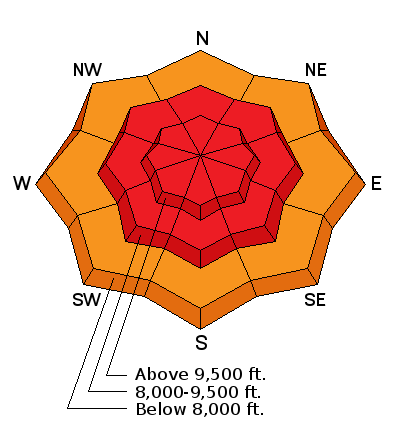
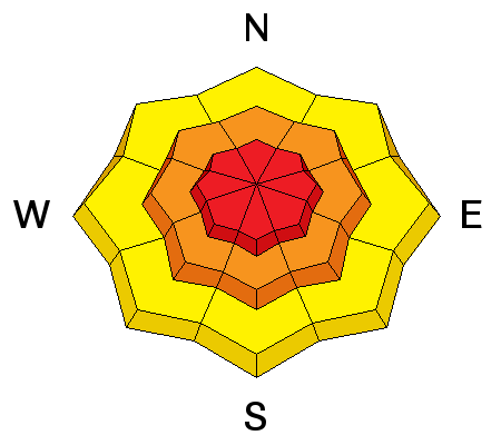
bottom line The Avalanche Danger is HIGH on and below all mid and upper elevation slopes approaching 35 degrees and steeper. Natural avalanches are occurring as I type. With continued snow and increasing winds in the forecast, the avalanche danger will remain HIGH throughout the day. Avoid travel on and below steep slopes – backcountry travel in avalanche terrain is not recommended today.
Safer terrain: we just filled in the old tracks again, so head back to the low angle, wind sheltered terrain, especially at the low to mid elevations, with no steep slopes above you.
|
 |
special announcement There are still spaces in the Women’s Backcountry 101 avalanche class at Brighton (Feb 4/6) and the Women’s Snowbasin Avalanche Awareness class Feb (18/20). For more info on those classes and other education offerings through out the state, check out our Education Page.
Drew has printed out an excerpt from Roger Atkin’s essay Here, titling it “The Selection of Desires”. |
 |
current conditions It’s another great refill, with storm totals in the 5 to 10” range, and snow still falling in many locations. Temperatures are in the twenties, with a few teens along the highest ridge lines. The northwesterly winds are currently light, with averages in the 10 to 15 mph, but speeds are forecast to increase today. |
 |
recent activity At least 6 avalanches have occurred since 5 am on the steep, southerly facing slopes of Little Cottonwood. From yesterday, no new avalanches were reported from the backcountry, though we are continuing to update the Avalanche List with activity from earlier this week. |
| type | aspect/elevation | characteristics |
|---|

|

|
LIKELIHOOD
 LIKELY
UNLIKELY
SIZE
 LARGE
SMALL
TREND
 INCREASING DANGER
SAME
DECREASING DANGER
|
|
description
The largest, most dangerous avalanches today will be slides breaking on one of the deeper faceted weak layers.
|
| type | aspect/elevation | characteristics |
|---|

|
|
LIKELIHOOD
LIKELY
UNLIKELY
SIZE
LARGE
SMALL
TREND
INCREASING DANGER
SAME
DECREASING DANGER
|
|
description
There is snow to move today, and as the winds increase they will create sensitive new drifts and cornices, mostly along the ridge lines. Avoid any denser, cracky wind drifts on steep slopes. Drifts from yesterday's southerly winds will be hidden beneath the new snow. |
| type | aspect/elevation | characteristics |
|---|

|

|
LIKELIHOOD
 LIKELY
UNLIKELY
SIZE
LARGE
SMALL
TREND
INCREASING DANGER
SAME
DECREASING DANGER
|
|
description
And finally, the new snow will bond poorly to slopes with slick hard wind and sun crusts. Sluffs or soft slabs in continuously steep terrain will entrain snow all the way down slope, resulting in faster, longer running slides than expected. |
 |
weather As the storm continues, an additional 3 to 6” of snow is expected today, with the higher amounts in areas favored by northwest flow. The northwesterly winds will pick up, averaging 20 mph and gusting to 30 mph; along the highest ridgelines, averages could reach 30 mph, with gusts to 45. 10,000’ temperatures will cool into mid teens. Snow showers will continue overnight into Monday morning, with an additional few inches possible. Strong warming is forecast for Tuesday through Thursday as high pressure builds in. |
| general announcements Remember your information can save lives. If you see anything we should know about, please participate in the creation of our own community avalanche advisory by submitting snow and avalanche conditions. You can also call us at 801-524-5304, email by clicking HERE, or include #utavy in your tweet or Instagram. To get help in an emergency (to launch a rescue) in the Wasatch, call 911. Be prepared to give your GPS coordinates or the run name. Dispatchers have a copy of the Wasatch Backcountry Ski map. Backcountry Emergencies. It outlines your step-by-step method in the event of a winter backcountry incident. If you trigger an avalanche in the backcountry, but no one is hurt and you do not need assistance, please notify the nearest ski area dispatch to avoid a needless response by rescue teams. Thanks. Salt Lake and Park City – Alta Central (801-742-2033), Canyons Resort/PCMR Dispatch (435)615-1911 Snowbasin Resort Dispatch (801-620-1017), Powder Mountain Dispatch (801-745-3772 x 123). Sundance Dispatch (801-223-4150) EMAIL ADVISORY If you would like to get the daily advisory by email you will need to subscribe here. DAWN PATROL Hotline updated daily by 5-530am - 888-999-4019 option 8. Twitter Updates for your mobile phone - DETAILS UDOT canyon closures: LINK TO UDOT, or on Twitter, follow @UDOTavy, @CanyonAlerts or @AltaCentral Utah Avalanche Center mobile app - Get your advisory on your iPhone along with great navigation and rescue tools. Powderbird Helicopter Skiing - Blog/itinerary for the day Lost or Found something in the backcountry? - http://nolofo.com/ To those skinning uphill at resorts: it is your responsibility to know the resort policy on uphill travel. You can see the uphill travel policy for each resort here. IMPORTANT: Before skinning or hiking at a resort under new snow conditions, check in with Ski Patrol. Resorts can restrict or cut off access if incompatible with control and grooming operations. Benefit the Utah Avalanche Center when you shop from Backcountry.com or REI: Click this link for Backcountry.com or this link to REI, shop, and they will donate a percent of your purchase price to the UAC. Both offer free shipping (with some conditions) so this costs you nothing! Benefit the Utah Avalanche Center when you buy or sell on ebay - set the Utah Avalanche Center as a favorite non-profit in your ebay account here and click on ebay gives when you buy or sell. You can choose to have your seller fees donated to the UAC, which doesn't cost you a penny. This information does not apply to developed ski areas or highways where avalanche control is normally done. This advisory is from the U.S.D.A. Forest Service, which is solely responsible for its content. This advisory describes general avalanche conditions and local variations always exist. |