| Please join us at the 23rd annual Black Diamond Fall Fundraiser Party Thursday Sept 15. Tickets are on sale now here, at the Black Diamond store & at REI. Special bonus raffle for online ticket purchasers! |
| Please join us at the 23rd annual Black Diamond Fall Fundraiser Party Thursday Sept 15. Tickets are on sale now here, at the Black Diamond store & at REI. Special bonus raffle for online ticket purchasers! |
| Advisory: Provo Area Mountains | Issued by Drew Hardesty for Tuesday - January 19, 2016 - 7:28am |
|---|


|
bottom line Most terrain has a MODERATE danger. A MODERATE danger for avalanches in the new snow exists on nearly all aspects and elevations on slopes approaching 35 degrees and steeper. Human triggered avalanches into deeper layers of the snowpack may be more likely on steep north to east facing slopes above 9000'. Avoid being on or beneath steep sunlit terrain with daytime warming. Caveat! Another storm is on the way tonight - if the southwest winds pick up earlier than anticipated, expect the danger to rise accordingly with additional wind drifting.
|
 |
special announcement From our friends in the Tetons. Same message for here - Thursday 6:00pm - Utah Adventure Journal Speaker Series continues at Snowbird's Wildflower Lounge with a special presentation from local snowboarder Cindi Lou Grant. "Ride in, Ride out" is the story of Cindi and her husband Zach's dream to have a home with the ultimate access to the mountains. If you can't make it to this talk check out the entire list of speakers here: https://goo.gl/ha05ir Our Dutch Auction continues: 180 cm La Sportiva Vapor Nano Skis (130/103/120mm -1200g). List price is $1,200. Here's the deal: We are offering these skis for sale to the first person that contacts us with a commitment to purchase. THE PRICE TODAY IS $900.00 AND WILL DROP $50 TOMORROW. The price will drop $50 per day until someone buys the skis. We'll toss in a free UAC t-shirt or trucker hat and handful of Clif Bar product. Contact: [email protected] |
 |
current conditions Under promise and over deliver. It snowed hard during the day yesterday and then wrapped up prior to midnight. Storm totals are up to about a foot in the Cottonwoods, 6-8" along the Park City ridgeline and Ogden area mountains, and 4-6" in Provo. Mountain temperatures lie in the single digits to mid-teens; winds are northwesterly and on good behaviour - blowing 10mph with gusts to 15. 11,000' anemometers are blowing a bit of snow around with hourly speeds in the 18-25mph range. For those headed to the highest peaks, it's worth noting that the 11,000' hourly averages were in the 20-30mph range with gusts to 45 for a few hours just before midnight. |
 |
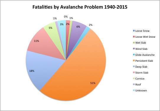
recent activity One touring party found mostly stable snow along the Cutler ridge, but would could imagine some shallow wind drifts and loose snow avalanching during peak instability yesterday. Avalanche reduction at the ski areas include manageable wind slabs and storm slabs with ski cuts. In the Central Wasatch - New snow activity: High precipitation intensity tends to lead to avalanches. Mountain resorts reported widespread loose and shallow wind slab avalanches in the steeper terrain yesterday that were easily mitigated with ski cuts. (from the UAC avy encyclopedia - though the photo is not the best). Old snow activity: This is what prematurely ages avalanche pros and account for 69% of our avalanche related fatalities in Utah.
|
| type | aspect/elevation | characteristics |
|---|

|

|
LIKELIHOOD
 LIKELY
UNLIKELY
SIZE
 LARGE
SMALL
TREND
 INCREASING DANGER
SAME
DECREASING DANGER
|
|
description
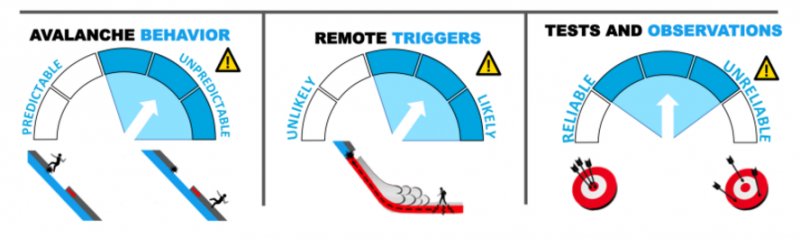
High precipitation intensity certainly has its own issues with the new snow (sluffing, storm snow, etc), but it can certainly add additional stress to mid-pack weak layers or basal weaknesses where the overall snowpack remains thin. This is where the repeater avalanches (up to a dozen now) are haunting us in the backcountry and have done so since January 7th. They have been primarily active on north to east facing slopes and generally above 9500' Outliers have been as low as 8500' and on west and northwest facing slopes. This - as above in Recent Activity was referred to as Old Snow activity and is generally described as Unmanageable. See the metrics below. Thanks to Jim Conway for his help with the info-graphics. As always, you can click on the 'i' next to the Problem icon for more info.
|
| type | aspect/elevation | characteristics |
|---|

|

|
LIKELIHOOD
LIKELY
UNLIKELY
SIZE
 LARGE
SMALL
TREND
 INCREASING DANGER
SAME
DECREASING DANGER
|
|
description
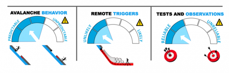
On the steeper slopes of all aspects yesterday, people were able to initiate longer running Dry Loose Avalanches in the low density snow; today, my sense is that these will still be possible in the steeper terrain (perhaps particularly on the steep sun-kissed terrain), but settlement and intra-storm weaknesses may be something of concern on slopes steeper than about 35 degrees on all aspects. These Storm Slabs should tend to be significantly more predictable than the Persistent Slab problem, above. The one concern is on the steep southerly aspects that formed a crust on Sunday and may be more sensitive with human weight today. Last, but not least, Wind Slabs may be found along the highest elevations as the 11,000' west to northwest winds were gusty for a few hours just before midnight. Ski cuts, cornice drops, and other tracks on the slope will give some indicator of stability with these three issues (Loose Dry Snow, Storm Slab, Wind Slab). As always, you can click on the 'i' next to the Problem icon for more info. Storm Slab metrics, below.
|
| type | aspect/elevation | characteristics |
|---|

|
|
LIKELIHOOD
LIKELY
UNLIKELY
SIZE
LARGE
SMALL
TREND
 INCREASING DANGER
SAME
DECREASING DANGER
|
|
description
Increasingly high, direct sun, and mountain temperatures approaching 40° at 8000' and the mid-20s at 10,000' may soften the steep sunlit slopes to the point of wet avalanching in the new snow. Cold dry snow seeing sun/heating for the first time can be particularly unstable. Choose appropriate terrain with the daytime heating. |
 |
weather We'll have clear to partly cloudy skies today ahead of yet another storm slated for tonight into tomorrow. Expect increasing clouds, temps, and southwest winds ahead of this two part system. Temps will reach toward the mid to upper 30s at 8000', the mid 20s at 8000'. The southwest winds should pick up this afternoon and evening, blowing 35-40mph from the west-southwest. Additional snow totals may add up to 6-12" by tomorrow eve. Brief ridging and sunny skies with rapid warming slated for Thursday and Friday, followed by another set of storms for the weekend. |
| general announcements Remember your information can save lives. If you see anything we should know about, please participate in the creation of our own community avalanche advisory by submitting snow and avalanche conditions. You can also call us at 801-524-5304, email by clicking HERE, or include #utavy in your tweet or Instagram. To get help in an emergency (to launch a rescue) in the Wasatch, call 911. Be prepared to give your GPS coordinates or the run name. Dispatchers have a copy of the Wasatch Backcountry Ski map. Backcountry Emergencies. It outlines your step-by-step method in the event of a winter backcountry incident. If you trigger an avalanche in the backcountry, but no one is hurt and you do not need assistance, please notify the nearest ski area dispatch to avoid a needless response by rescue teams. Thanks. Salt Lake and Park City – Alta Central (801-742-2033), Canyons Resort/PCMR Dispatch (435)615-1911 Snowbasin Resort Dispatch (801-620-1017), Powder Mountain Dispatch (801-745-3772 x 123). Sundance Dispatch (801-223-4150) EMAIL ADVISORY If you would like to get the daily advisory by email you will need to subscribe here. DAWN PATROL Hotline updated daily by 5-530am - 888-999-4019 option 8. Twitter Updates for your mobile phone - DETAILS UDOT canyon closures: LINK TO UDOT, or on Twitter, follow @UDOTavy, @CanyonAlerts or @AltaCentral Utah Avalanche Center mobile app - Get your advisory on your iPhone along with great navigation and rescue tools. Powderbird Helicopter Skiing - Blog/itinerary for the day Lost or Found something in the backcountry? - http://nolofo.com/ To those skinning uphill at resorts: it is your responsibility to know the resort policy on uphill travel. You can see the uphill travel policy for each resort here. IMPORTANT: Before skinning or hiking at a resort under new snow conditions, check in with Ski Patrol. Resorts can restrict or cut off access if incompatible with control and grooming operations. Benefit the Utah Avalanche Center when you shop from Backcountry.com or REI: Click this link for Backcountry.com or this link to REI, shop, and they will donate a percent of your purchase price to the UAC. Both offer free shipping (with some conditions) so this costs you nothing! Benefit the Utah Avalanche Center when you buy or sell on ebay - set the Utah Avalanche Center as a favorite non-profit in your ebay account here and click on ebay gives when you buy or sell. You can choose to have your seller fees donated to the UAC, which doesn't cost you a penny. This information does not apply to developed ski areas or highways where avalanche control is normally done. This advisory is from the U.S.D.A. Forest Service, which is solely responsible for its content. This advisory describes general avalanche conditions and local variations always exist. |