| Please join us at the 23rd annual Black Diamond Fall Fundraiser Party Thursday Sept 15. Tickets are on sale now here, at the Black Diamond store & at REI. Special bonus raffle for online ticket purchasers! |
| Please join us at the 23rd annual Black Diamond Fall Fundraiser Party Thursday Sept 15. Tickets are on sale now here, at the Black Diamond store & at REI. Special bonus raffle for online ticket purchasers! |
| Advisory: Provo Area Mountains | Issued by Evelyn Lees for Thursday - December 24, 2015 - 7:16am |
|---|


|
bottom line The Avalanche Warning has been continued for the all mountains of northern and central Utah. The avalanche danger is HIGH in upper and mid elevation terrain, where large avalanches breaking to the ground and running long distances have occurred. Human triggered slides are very likely today, and can be triggered remotely from a distance and from below. Remember, most of the Provo ice climbs are in avalanche paths.
|
 |
avalanche warning THE FOREST SERVICE UTAH AVALANCHE CENTER IN SALT LAKE CITY HAS EXTENDED THE BACKCOUNTRY AVALANCHE WARNING. * TIMING...EXTENDED THROUGH 6 AM MST FRIDAY * AFFECTED AREA...ALL THE MOUNTAINS OF NORTHERN AND CENTRAL UTAH AND SOUTHEASTERN IDAHO TO INCLUDE THE WASATCH RANGE, THE BEAR RIVER RANGE, THE WESTERN UINTAS AND THE MANTI-SKYLINE PLATEAU. OTHER MOUNTAIN RANGES WILL LIKELY BE AFFECTED AS WELL * AVALANCHE DANGER...THE AVALANCHE DANGER FOR THE WARNING AREA IS HIGH * IMPACTS...HEAVY SNOWFALL COMBINED WITH STRONG WINDS HAS CREATED WIDESPREAD AREAS OF UNSTABLE SNOW. HUMAN TRIGGERED AVALANCHES ARE LIKELY AND WILL OCCUR IN MANY AREAS. STAY OFF OF AND OUT FROM UNDER SLOPES STEEPER THAN 30 DEGREES. |
 |
current conditions As skies struggle to clear this morning, temperatures have dropped into the single digits at 10,000’. An overnight dusting of 2 to 4 inches of snow caps off the 3 to 5 foot storm totals. The water content is in the 3 to 5 inch range. Winds have shifted back to the southwest, and are light, with most stations averaging less than 15 mph. |
 |
recent activity The huge Cascade Ridge natural was yesterday’s headliner, with a video and more photos in the observation. Glimpses of additional natural avalanche activity were reported throughout the Provo area mountains. Avalanche reduction work continued to trigger large numbers of both new snow slides and slides breaking to the ground in the northern Utah mountains. Some slopes have slid two or more times in this storm cycle. In portions of the Provo area mountains, 2 avalanche cycles occurred yesterday. A loose, dry avalanche cycle at the lower elevations, and new snow soft slabs at 10,000' and above, that then stepped down to the ground.
Brett Kobernik photos, Provo area mountains, avalanche debris
|
| type | aspect/elevation | characteristics |
|---|

|
|
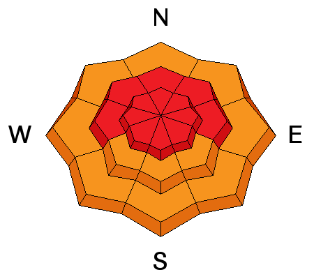
LIKELIHOOD
 LIKELY
UNLIKELY
SIZE
 LARGE
SMALL
TREND
 INCREASING DANGER
SAME
DECREASING DANGER
|
|
description
Dangerous avalanche conditions exist – large avalanches breaking to the ground can be triggered from on slope or from a distance or below. These slides are failing near the ground on weak sugary faceted snow. The snowpack will become more stubborn today, and tracks on a slope are not a sign of stability. The second or even 5th person can trigger a slide. Collapsing or whoomphing sounds indicate you are in the danger zone - get off of and out from under steep slopes.
If you do head into the backcountry, you must have the skills and knowledge to avoid all avalanche terrain (slopes steeper than 30 degrees), including avalanche run out zones and historic avalanche paths. Smaller slopes and terrain traps at the mid and lower elevations can be deadly too. |
| type | aspect/elevation | characteristics |
|---|

|
|
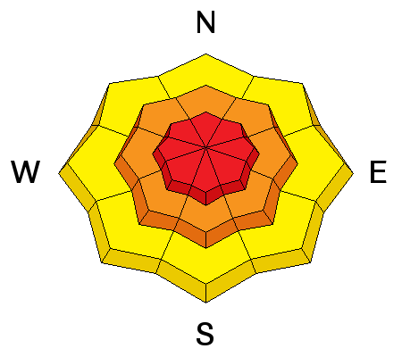
LIKELIHOOD
LIKELY
UNLIKELY
SIZE
 LARGE
SMALL
TREND
INCREASING DANGER
SAME
DECREASING DANGER
|
|
description
Yesterday’s strong winds drifted snow on all aspects and all elevations, and numerous avalanches were breaking in the new snow and wind drifts. In addition, any smaller wind slab triggered has the potential to break to the ground. Small, steep features such as road banks, creek and ravine walls and house roofs can avalanche, with debris piling up deep enough to bury a person. |
 |
weather There will be a much-needed break in the snow and wind today, with partly cloudy skies and only a few snow flurries. The southwesterly winds will increase just a bit, averaging 20 to 30 mph across the highest peaks, and in the 10 to 20 mph range at 10,000’. Temperatures will warm to near 10 at 10,000’.
Increasing clouds tonight, with the final cold front reaching the Wasatch mountains after midnight. Up to a foot of additional snow is possible by Friday evening for areas favored by northwest flow. A high-pressure ridge will build in for the weekend. |
general announcements
|