| Please join us at the 23rd annual Black Diamond Fall Fundraiser Party Thursday Sept 15. Tickets are on sale now here, at the Black Diamond store & at REI. Special bonus raffle for online ticket purchasers! |
| Please join us at the 23rd annual Black Diamond Fall Fundraiser Party Thursday Sept 15. Tickets are on sale now here, at the Black Diamond store & at REI. Special bonus raffle for online ticket purchasers! |
| Advisory: Provo Area Mountains | Issued by Mark Staples for Tuesday - December 15, 2015 - 7:28am |
|---|


|
bottom line Today there is a HIGH danger on at upper elevations. The last 48 hours of snowfall combined with increased winds overnight has created very dangerous avalanche conditions and travel in avalanche terrain is NOT recommended. Conditions are tricky because we don't know exactly how close the snowpack is to its breaking point, and this uncertainty is good reason to be conservative.
|
 |
avalanche warning THE FOREST SERVICE UTAH AVALANCHE CENTER IN SALT LAKE CITY HAS CONTINUED A BACKCOUNTRY AVALANCHE WARNING. * TIMING…IN EFFECT FROM 6 AM MST THIS MORNING TO 6 AM MST WEDNESDAY * AFFECTED AREA…FOR THE MOUNTAINS OF NORTHERN AND CENTRAL UTAH INCLUDING THE WASATCH RANGE NEAR OGDEN, SALT LAKE CITY AND PROVO AS WELL AS THE MANTI SKYLINE. * AVALANCHE DANGER…THE AVALANCHE DANGER FOR THE WARNING AREA WILL BE HIGH TODAY. * IMPACTS…HEAVY SNOWFALL ON A WEAK SNOWPACK AND WIND DRIFTING OVERNIGHT HAVE CREATING WIDESPREAD AREAS OF UNSTABLE SNOW. TRAVEL IN AVALANCHE TERRAIN IS NOT RECOMMENDED. STAY OFF OF AND OUT FROM UNDER SLOPES STEEPER THAN 30 DEGREES. BACKCOUNTRY TRAVELERS SHOULD CONSULT WWW.UTAHAVALANCHECENTER.ORG OR CALL 1-888-999-4019 FOR MORE DETAILED INFORMATION. THIS WARNING DOES NOT APPLY TO SKI AREAS WHERE AVALANCHE HAZARD REDUCTION MEASURES ARE PERFORMED. |
 |
special announcement
Fireside Chats are back - Come down to Black Diamond this Wednesday night December 16th at 7:30pm. UAC forecaster Drew Hardesty and recently retired Chief Meteorologist Larry Dunn will be hosting a talk "You Too Can Be a Dirtbag Meteorologist - tips and tricks for forecasting the Greatest Snow on Earth". Bring your notebook, laptop, and picnic supplies for what should be a great event. For more info on this and other UAC events, check out Events page. |
 |
current conditions Overnight another couple inches of snow fell containing about 0.1-0.2 inches of water. Storm totals are at least a foot of snow with 0.8 to 1.2 inches of water. Winds appear to be mostly light and were blowing 2-4 mph from the north at 8800 feet. At higher elevations near Salt Lake City, winds were blowing 20-40 mph and I suspect they are doing the same in the mountains near Provo.
|
 |
recent activity Near Provo Canyon yesterday, one natural avalanche was observed on a NE aspect at 8600 feet that was about a foot deep and 65 feet wide. It was on a steep, wind loaded slope. |
| type | aspect/elevation | characteristics |
|---|

|
|
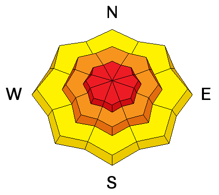
LIKELIHOOD
 LIKELY
UNLIKELY
SIZE
 LARGE
SMALL
TREND
 INCREASING DANGER
SAME
DECREASING DANGER
|
|
description
Conditions will be tricky today. Recent snowfall does not contain enough water weight to create widespread and obvious signs of instability. Some slopes will be stable while many will not. Observers yesterday did not experience any cracking or collapsing of the snowpack, nor did they spot any natural avalanches other than a few sloughs in steep terrain. With more snow overnight and increased winds, there may be obvious signs of unstable snow like cracking, collapsing or natural avalanches, BUT there may not and this is the problem. It's hard to know exactly how close the snowpack is to its breaking point and avalanche science is not precise enough for us to know. I've been surprised in similar situations when I did not think there was enough of a load or enough of a cohesive slab in place to cause unstable conditions but then I was able to remotely trigger avalanches. The LESSON - don't trust facets especially the first time they receive a load of new snow. We don't have any history with this snowpack to know how it will respond to the last 48 hours of loading. However, we know that the snowpack is weak. We also know that northerly winds increased overnight and should be transporting snow at elevations above 10,000 feet. North aspects have several layers of weak faceted snow. Southerly aspects may be trickier because they contain weak facets sandwiched between ice crusts. The likelihood of avalanche activity may or may not fit the definition of HIGH danger, but I would be following travel recommendations for HIGH danger which are to avoid avalanche terrain.
|
 |
weather The storm system responsible for the last 48 hours of snowfall is moving east this morning and snowfall should taper off today. Another 2-4 inches of snow could fall this morning. Winds should continue from the NW at 10-20 mph with high temperatures today only reaching the upper teens and low 20s F. Winds above 10,000 feet should have gusts of 30-40 mph. |
| general announcements Remember your information can save lives. If you see anything we should know about, please participate in the creation of our own community avalanche advisory by submitting snow and avalanche conditions. You can also call us at 801-524-5304, email by clicking HERE, or include #utavy in your tweet or Instagram. To get help in an emergency (to launch a rescue) in the Wasatch, call 911. Be prepared to give your GPS coordinates or the run name. Dispatchers have a copy of the Wasatch Backcountry Ski map. If you trigger an avalanche in the backcountry, but no one is hurt and you do not need assistance, please notify the nearest ski area dispatch to avoid a needless response by rescue teams. Thanks. Salt Lake and Park City – Alta Central (801-742-2033), Canyons Resort/PCMR Dispatch (435)615-1911 Snowbasin Resort Dispatch (801-620-1017), Powder Mountain Dispatch (801-745-3772 x 123). Sundance Dispatch (801-223-4150) EMAIL ADVISORY If you would like to get the daily advisory by email you will need to subscribe here. DAWN PATROL Hotline updated daily by 5-530am - 888-999-4019 option 8. Twitter Updates for your mobile phone - DETAILS UDOT canyon closures: LINK TO UDOT, or on Twitter, follow @UDOTavy, @CanyonAlerts or @AltaCentral Utah Avalanche Center mobile app - Get your advisory on your iPhone along with great navigation and rescue tools. Wasatch Powderbird Guides Blog/Itinerary for the Day. Lost or Found something in the backcountry? - http://nolofo.com/ To those skinning uphill at resorts: it is your responsibility to know the resort policy on uphill travel. You can see the uphill travel policy for each resort here. IMPORTANT: Before skinning or hiking at a resort under new snow conditions, check in with Ski Patrol. Resorts can restrict or cut off access if incompatible with control and grooming operations. Benefit the Utah Avalanche Center when you shop from Backcountry.com or REI: Click this link for Backcountry.com or this link to REI, shop, and they will donate a percent of your purchase price to the UAC. Both offer free shipping (with some conditions) so this costs you nothing! Benefit the Utah Avalanche Center when you buy or sell on ebay - set the Utah Avalanche Center as a favorite non-profit in your ebay account here and click on ebay gives when you buy or sell. You can choose to have your seller fees donated to the UAC, which doesn't cost you a penny. This information does not apply to developed ski areas or highways where avalanche control is normally done. This advisory is from the U.S.D.A. Forest Service, which is solely responsible for its content. This advisory describes general avalanche conditions and local variations always exist. |