| Please join us at the 23rd annual Black Diamond Fall Fundraiser Party Thursday Sept 15. Tickets are on sale now here, at the Black Diamond store & at REI. Special bonus raffle for online ticket purchasers! |
| Please join us at the 23rd annual Black Diamond Fall Fundraiser Party Thursday Sept 15. Tickets are on sale now here, at the Black Diamond store & at REI. Special bonus raffle for online ticket purchasers! |
| Advisory: Provo Area Mountains | Issued by Evelyn Lees for Thursday - December 10, 2015 - 7:07am |
|---|

|
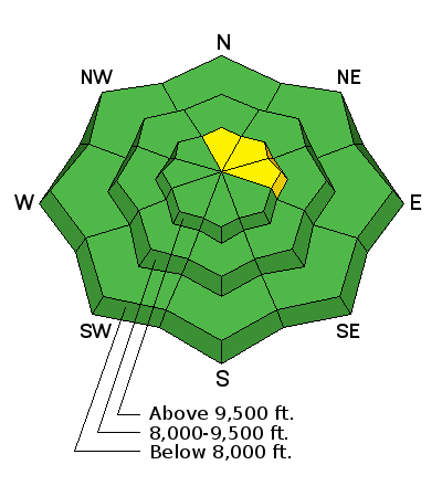
bottom line The avalanche danger is LOW this morning, but it could rise to MODERATE later today if the snow starts to drift where you are. Avoid any new wind drifts on slopes approaching 35 degrees or steeper. Overnight, the addition of new snow will continue to increase the avalanche danger to at least MODERATE, with slides potentially breaking into deeper layers.
|
 |
current conditions A cold Pacific storm is forecast to reach northern Utah by this evening. Ahead of it, temperatures are a bit cooler this morning – with most stations near or below freezing. The southwesterly winds are just starting to increase – into the 10 to 20 mph range, gusting in the 40s and 50s.
Snow coverage continues to be bleak – average depths are in the 8 to 15” range in the Provo area mountains, with the pack unsupportable at times, so hitting rocks or logs is likely. Access to the higher terrain is difficult. Snow quality isn’t much better - the surface sports a combo of breakable wind and ice crusts until you get into shady, wind sheltered upper elevation terrain. |
 |
recent activity No new avalanches have been reported from the backcountry for the past few days. |
| type | aspect/elevation | characteristics |
|---|

|
|
LIKELIHOOD
 LIKELY
UNLIKELY
SIZE
 LARGE
SMALL
TREND
 INCREASING DANGER
SAME
DECREASING DANGER
|
|
description
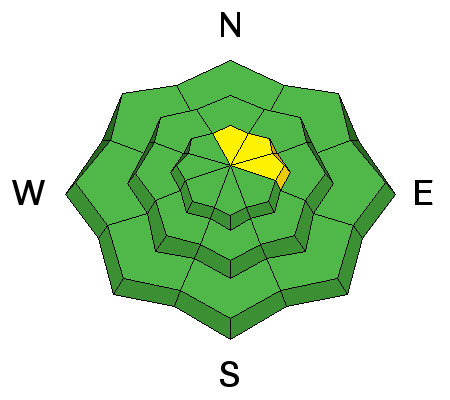
Snow available for transport is scarce, but the as winds speeds increase today or it starts to snow late this afternoon, some new sensitive drifts will form. Most of the drifts will be found in the upper elevation terrain, with some drifts well off the ridgelines and down in open bowls at slope break overs and around terrain features.
Days with increasing avalanche danger are tricky, so stay focused and as soon as you identify changing avalanche conditions – the new sensitive winds drifts – switch to wind sheltered terrain and lower angle slopes |
| type | aspect/elevation | characteristics |
|---|

|
|
LIKELIHOOD
 LIKELY
UNLIKELY
SIZE
 LARGE
SMALL
TREND
INCREASING DANGER
SAME
DECREASING DANGER
|
|
description
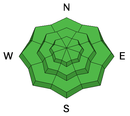
Any triggered wind drift has the potential to break into the sugary weak snow lower in the pack, resulting in a deeper, wider slide. Again, while there is a LOW danger of slides this morning, stability will change fast once drifts start to form or it starts to snow. A slide breaking into a faceted layer will large enough to take you for a ride and especially dangerous to get caught in because you will be bouncing off rocks due to the shallow snowpack. |
 |
weather A strong cold front will cross northern Utah around dusk today. Ahead of the front, we’ll have a last warm, blustery day, with 8,000’ temperatures rising into the mid 40s and 10,000’ temperatures into the mid 30s. The southwesterly winds will be ramping up by noon, peaking in the evening with speeds averaging near 30 and gusts in the 40s. Gusts across the high peaks may reach into the 80s. Snowfall should start around dusk, and 4 to 8” of snow are expected overnight. Temperatures will plummet into the teens, and winds shift to the northwest and decrease. The fast moving storm will be out of here by Friday morning, leaving behind a few lingering snow showers. |
| general announcements Remember your information can save lives. If you see anything we should know about, please participate in the creation of our own community avalanche advisory by submitting snow and avalanche conditions. You can also call us at 801-524-5304, email by clicking HERE, or include #utavy in your tweet or Instagram. To get help in an emergency (to launch a rescue) in the Wasatch, call 911. Be prepared to give your GPS coordinates or the run name. Dispatchers have a copy of the Wasatch Backcountry Ski map. If you trigger an avalanche in the backcountry, but no one is hurt and you do not need assistance, please notify the nearest ski area dispatch to avoid a needless response by rescue teams. Thanks. Salt Lake and Park City – Alta Central (801-742-2033), Canyons Resort/PCMR Dispatch (435)615-1911 Snowbasin Resort Dispatch (801-620-1017), Powder Mountain Dispatch (801-745-3772 x 123). Sundance Dispatch (801-223-4150) EMAIL ADVISORY If you would like to get the daily advisory by email you will need to subscribe here. DAWN PATROL Hotline updated daily by 5-530am - 888-999-4019 option 8. Twitter Updates for your mobile phone - DETAILS UDOT canyon closures: LINK TO UDOT, or on Twitter, follow @UDOTavy, @CanyonAlerts or @AltaCentral Utah Avalanche Center mobile app - Get your advisory on your iPhone along with great navigation and rescue tools. Wasatch Powderbird Guides Blog/Itinerary for the Day. Lost or Found something in the backcountry? - http://nolofo.com/ To those skinning uphill at resorts: it is your responsibility to know the resort policy on uphill travel. You can see the uphill travel policy for each resort here. IMPORTANT: Before skinning or hiking at a resort under new snow conditions, check in with Ski Patrol. Resorts can restrict or cut off access if incompatible with control and grooming operations. Benefit the Utah Avalanche Center when you shop from Backcountry.com or REI: Click this link for Backcountry.com or this link to REI, shop, and they will donate a percent of your purchase price to the UAC. Both offer free shipping (with some conditions) so this costs you nothing! Benefit the Utah Avalanche Center when you buy or sell on ebay - set the Utah Avalanche Center as a favorite non-profit in your ebay account here and click on ebay gives when you buy or sell. You can choose to have your seller fees donated to the UAC, which doesn't cost you a penny. This information does not apply to developed ski areas or highways where avalanche control is normally done. This advisory is from the U.S.D.A. Forest Service, which is solely responsible for its content. This advisory describes general avalanche conditions and local variations always exist. |