| Please join us at the 23rd annual Black Diamond Fall Fundraiser Party Thursday Sept 15. Tickets are on sale now here, at the Black Diamond store & at REI. Special bonus raffle for online ticket purchasers! |
| Please join us at the 23rd annual Black Diamond Fall Fundraiser Party Thursday Sept 15. Tickets are on sale now here, at the Black Diamond store & at REI. Special bonus raffle for online ticket purchasers! |
| Advisory: Provo Area Mountains | Issued by Evelyn Lees for Friday - December 4, 2015 - 6:53am |
|---|

|
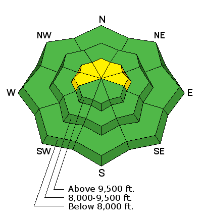
bottom line The avalanche danger is MODERATE today for triggering a wind slab on upper elevation slopes facing west through north through east. The most likely place to trigger a slide would be a slope approaching 35 degrees or steeper, in the wind zone along a higher ridgeline. Drifts will be more isolated on other upper elevation aspects and in mid elevation terrain. Drew will update this forecast Saturday morning.
|
 |
current conditions t’s another one of those warm before the “non-storm” mornings - temperatures in the Provo area mountains are in the mid 30s to low 40’s this morning at the low to mid elevations.. The southerly winds ramped up - 20 mph averages with gusts in the 40s, and the highest peaks in the Wasatch range averaging closer to 40 mph, with gusts in the 60s at times.
Access in the Provo area mountains continues to be difficult due to the lack of low and mid elevation snow. The shallow and weakening snow limits travel for all users, and is mostly unsupportable for snow machines off the packed roads. The very shallow snowpack means hitting rocks or logs is likely. |
 |
recent activity No new avalanches have been reported from the backcountry for the past few days. |
| type | aspect/elevation | characteristics |
|---|

|
|
LIKELIHOOD
 LIKELY
UNLIKELY
SIZE
 LARGE
SMALL
TREND
 INCREASING DANGER
SAME
DECREASING DANGER
|
|
description
Despite a shallow snowpack and some old hard snow surfaces, the strong winds will find snow to drift into new wind slabs. These wind slabs will be landing on a variety of weak old snow surfaces. Avoid these dense, cracky drifts on slopes approaching 35 degrees or steeper. While most widespread along the upper elevation ridges, some drifts will be well off the ridgelines - at slope break overs, around terrain features and even on mid elevation slopes. Find small test slopes to jump on to help you evaluate the depth and sensitivity of the new drifts. |
 |
weather A weak (and splitting) trough crossing Utah today will produce mostly cloudy skies, and perhaps even a few snowflakes this afternoon, though accumulations will be scarce. Temperatures probably peaked a few hours ago, and will slowly decrease as cold air filters in behind the front. 10,000’ temperatures will drop to near 20 by evening, and into the mid teens by tomorrow morning. Winds will also decrease through out the day, and eventually shift to the northwest. Saturday will be cooler, with highs in the mid teens to mid 20s, light winds and clearing skies. |
| general announcements Remember your information can save lives. If you see anything we should know about, please participate in the creation of our own community avalanche advisory by submitting snow and avalanche conditions. You can also call us at 801-524-5304, email by clicking HERE, or include #utavy in your tweet or Instagram. To get help in an emergency (to launch a rescue) in the Wasatch, call 911. Be prepared to give your GPS coordinates or the run name. Dispatchers have a copy of the Wasatch Backcountry Ski map. If you trigger an avalanche in the backcountry, but no one is hurt and you do not need assistance, please notify the nearest ski area dispatch to avoid a needless response by rescue teams. Thanks. Salt Lake and Park City – Alta Central (801-742-2033), Canyons Resort/PCMR Dispatch (435)615-1911 Snowbasin Resort Dispatch (801-620-1017), Powder Mountain Dispatch (801-745-3772 x 123). Sundance Dispatch (801-223-4150) EMAIL ADVISORY If you would like to get the daily advisory by email you will need to subscribe here. DAWN PATROL Hotline updated daily by 5-530am - 888-999-4019 option 8. Twitter Updates for your mobile phone - DETAILS UDOT canyon closures: LINK TO UDOT, or on Twitter, follow @UDOTavy, @CanyonAlerts or @AltaCentral Utah Avalanche Center mobile app - Get your advisory on your iPhone along with great navigation and rescue tools. Wasatch Powderbird Guides Blog/Itinerary for the Day. Lost or Found something in the backcountry? - http://nolofo.com/ To those skinning uphill at resorts: it is your responsibility to know the resort policy on uphill travel. You can see the uphill travel policy for each resort here. IMPORTANT: Before skinning or hiking at a resort under new snow conditions, check in with Ski Patrol. Resorts can restrict or cut off access if incompatible with control and grooming operations. Benefit the Utah Avalanche Center when you shop from Backcountry.com or REI: Click this link for Backcountry.com or this link to REI, shop, and they will donate a percent of your purchase price to the UAC. Both offer free shipping (with some conditions) so this costs you nothing! Benefit the Utah Avalanche Center when you buy or sell on ebay - set the Utah Avalanche Center as a favorite non-profit in your ebay account here and click on ebay gives when you buy or sell. You can choose to have your seller fees donated to the UAC, which doesn't cost you a penny. This information does not apply to developed ski areas or highways where avalanche control is normally done. This advisory is from the U.S.D.A. Forest Service, which is solely responsible for its content. This advisory describes general avalanche conditions and local variations always exist. |