| During the month of April, Mark Miller will donate $75 to the charity of your choice (5 to chose from, including the Utah Avalanche Center!) Mark Miller Subaru has raised over $300k in the previous 6 Do Good Feel Good events. More Info here |  |
| During the month of April, Mark Miller will donate $75 to the charity of your choice (5 to chose from, including the Utah Avalanche Center!) Mark Miller Subaru has raised over $300k in the previous 6 Do Good Feel Good events. More Info here | |
| Advisory: Provo Area Mountains | Issued by Drew Hardesty for Friday - March 6, 2015 - 7:05am |
|---|

|
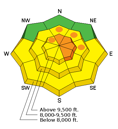
bottom line We continue to have areas of CONSIDERABLE danger on the upper elevation northerly through easterly facing terrain. The odds of triggering a 1-3' deep slide is slowly diminishing. The consequence remain the same. The danger for wet avalanches will rise to and perhaps exceed MODERATE on all the steep sun-exposed slopes with daytime warming. We have a danger gradient running north-south across the state with the danger even more pronounced in the Provo mountains and the Wasatch Plateau (where we have a Special Avalanche Bulletin)...all the way down to La Sals.
|
 |
special announcement Discount lift tickets are available at Backcountry.com. Thanks to Ski Utah and the Utah Resorts. All proceeds go towards paying for Utah Avalanche Center avalanche and mountain weather advisories. Join us at Brighton Mar 7 & 8 for Vertfest! Clinics include Companion Rescue, Terrain Selection, Steep Skiing, and Mountaineering for skiers/split-boarders, both open and women-only. There will also be gear demos and the Wasatch Powder Keg ski mountaineering race, all to benefit the Utah Avalanche Center. More info here. TWITTER - That guy that's checking his smartphone in the backcountry? It just might be the Utah Avalanche Center sending out real-time avalanche information via twitter-text/notification. Could be useful to find out the next bowl over just slid before diving into your line. Find out more here - |
 |
current conditions Skies are clear, mountain temps are roughly ten degrees warmer than they were yesterday morning (now in the upper teens and low 20s), and winds are generally less than 15mph from the northwest. Southerly and off aspects will have a quick-to-soften-sun crust. Northerly aspects are out of this world.
|
 |
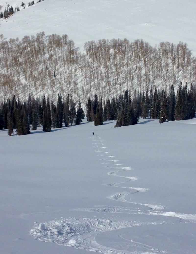
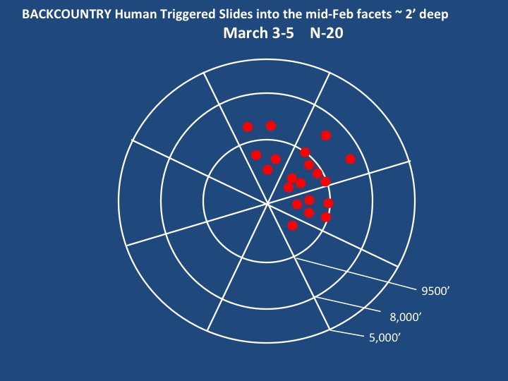
recent activity Yes, I know you're hungry. So am I. It's been a long, dry winter and now we have some of the best snow of the year. We've also had - by my count - 20 human triggered avalanches over the last couple days - and it's where that arc of desire and instability intersect where we have trouble.
Darce Trotter spotted a large natural off of Timpanogos yesteday - up to 3' deep and hundreds of feet wide - 9800' southeast facing.
Yesterday's action in the Central Wasatch included
Evelyn's preliminary accident report from the Hell's Canyon avalanche fatality can be found here. You can quickly scroll through all the pics across the range on our photos page here. Thanks to all the folks who called our office, submitted reports, and called Alta Central or the various ski patrol dispatch offices (info in our General Announcements below). Your information helps to verify conditions, which, in turn saves lives. Thanks. |
| type | aspect/elevation | characteristics |
|---|

|
|
LIKELIHOOD
 LIKELY
UNLIKELY
SIZE
 LARGE
SMALL
TREND
 INCREASING DANGER
SAME
DECREASING DANGER
|
|
description
Many steep lines continue to be hit with impunity - and this is what makes this type of avalanche so dangerous. Many of these will go remote to the person on the slope or ridgeline - or worse - from below. Slope cuts, cornice drops, even previous tracks on the slope = unreliable. Some slides have taken out previous tracks, even skin tracks. For my $, you have three options -
Persistent Slab Avalanches from Trent Meisenheimer on Vimeo. For more info on how to manage this type of avalanche, click on the 'i' next to the Persistent Slab icon...or go to our Avalanche Problem Toolbox for a cross-section comparison on all the different types of avalanches and accompanying Travel Advice.
|
| type | aspect/elevation | characteristics |
|---|

|
|
LIKELIHOOD
 LIKELY
UNLIKELY
SIZE
LARGE
SMALL
TREND
INCREASING DANGER
SAME
DECREASING DANGER
|
|
description
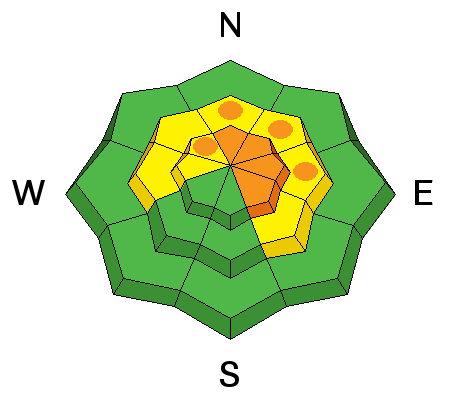
Forecasting wet avalanches can be easy, forecasting wet avalanches can be hard. I do like the trend of gradual warming and reasonable temps with the direct sun. But you have no business being on the steep southerly aspects during the heat of the day. Don't overstay your welcome when the snow becomes wet and unstable. Timing is key. |
 |
weather We'll have sunny skies, generally light west to northwesterly winds and temps rising to 40* at 8000', 30* at 10,000'. A building ridge of high pressure will dominate the weather pattern for the next week with maybe a cloud or two on Sunday. |
| general announcements Remember your information can save lives. If you see anything we should know about, please participate in the creation of our own community avalanche advisory by submitting snow and avalanche conditions. You can also call us at 801-524-5304, email by clicking HERE, or include #utavy in your tweet or Instagram. If you trigger an avalanche in the backcountry - especially if you are adjacent to a ski area – please call the following teams to alert them to the slide and whether anyone is missing or not. Rescue teams can be exposed to significant hazard when responding to avalanches, and do not want to do so when unneeded. Thanks. Salt Lake and Park City – Alta Central (801-742-2033), Canyons Resort Dispatch (435-615-3322) Snowbasin Resort Dispatch (801-620-1017), Powder Mountain Dispatch (801-745-3772 x 123). Sundance Dispatch (801-223-4150) EMAIL ADVISORY If you would like to get the daily advisory by email you will need to subscribe here. DAWN PATROL Hotline updated daily by 5-530am - 888-999-4019 option 8. Twitter Updates for your mobile phone - DETAILS UDOT canyon closures: LINK TO UDOT, or on Twitter, follow @UDOTavy, @CanyonAlerts or @AltaCentral Utah Avalanche Center mobile app - Get your advisory on your iPhone along with great navigation and rescue tools. Wasatch Powderbird Guides Blog/Itinerary for the Day. Lost or Found something in the backcountry? - http://nolofo.com/ Discount lift tickets are now available at Backcountry.com. Thanks to Ski Utah and the Utah Resorts. All proceeds go towards paying for Utah Avalanche Center avalanche and mountain weather advisories. To those skinning uphill at resorts: it is your responsibility to know the resort policy on uphill travel. You can see the uphill travel policy for each resort here. IMPORTANT: Before skinning or hiking at a resort under new snow conditions, check in with Ski Patrol. Resorts can restrict or cut off access if incompatible with control and grooming operations. Benefit the Utah Avalanche Center when you shop from Backcountry.com or REI: Click this link for Backcountry.com or this link to REI, shop, and they will donate a percent of your purchase price to the UAC. Both offer free shipping (with some conditions) so this costs you nothing! Benefit the Utah Avalanche Center when you buy or sell on ebay - set the Utah Avalanche Center as a favorite non-profit in your ebay account here and click on ebay gives when you buy or sell. You can choose to have your seller fees donated to the UAC, which doesn't cost you a penny. This information does not apply to developed ski areas or highways where avalanche control is normally done. This advisory is from the U.S.D.A. Forest Service, which is solely responsible for its content. This advisory describes general avalanche conditions and local variations always exist. |


_3.jpg)