| During the month of April, Mark Miller will donate $75 to the charity of your choice (5 to chose from, including the Utah Avalanche Center!) Mark Miller Subaru has raised over $300k in the previous 6 Do Good Feel Good events. More Info here |  |
| During the month of April, Mark Miller will donate $75 to the charity of your choice (5 to chose from, including the Utah Avalanche Center!) Mark Miller Subaru has raised over $300k in the previous 6 Do Good Feel Good events. More Info here | |
| Advisory: Provo Area Mountains | Issued by Drew Hardesty for Saturday - January 24, 2015 - 7:00am |
|---|


|
bottom line The avalanche danger is LOW but remember that your overall risk is amplified by your terrain choices. Minor shallow wind pockets, cornice fall, and shallow loose snow avalanches can be significant for those in severe and unforgiving terrain.
|
 |
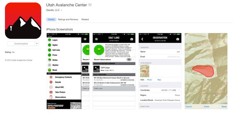
special announcement With a huge amount of thanks to local app developer Garafa..and the unwavering support from Black Diamond and Backcountry.com, we've just launched our UAC iPhone app 2.0 - one stop shopping for current avalanche conditions, weather, road closures, and more. Plus - See a slide? Trigger one? Hear a whumph or see shooting cracks? Take pics and submit your quick and easy report straight to us and help save lives -
|
 |
current conditions If you blinked, you missed the storm yesterday. It may have added up to a trace of snow. Standard weather record keepers would record that as .01". Skies are clear but we again should see some cloud build-up as yet another clipper races by to the north. Mountain temps are in the low to mid-20s with cooler air pooled in the basins and mountain valleys. Winds are from the north and generally less than 10mph except along the highest, most exposed ridgelines where they're blowing 20-25mph. BC riding conditions - with a little creativity and work - are quite good right now in the soft settled powder along the mid-elevation northerly glades. While you're watching the facets and surface hoar grow (it's like watching paint dry, but better), check out a couple of our blog posts from yesterday - Blog home page
|
 |
recent activity No avalanche activity was reported from the backcountry yesterday. |
| type | aspect/elevation | characteristics |
|---|

|
|
LIKELIHOOD
 LIKELY
UNLIKELY
SIZE
 LARGE
SMALL
TREND
 INCREASING DANGER
SAME
DECREASING DANGER
|
|
description
Same, same - If, as many these days assume, Moderate is the new Low - I wonder how people perceive the danger when it's actually Low. Risk is inherent with any mountain travel - and some of you wouldn't go at all if that wasn't the case. But...it is the case and today's concerns, while minor, will be more-so in and above unforgiving "no-fall" terrain. They include -
|
 |
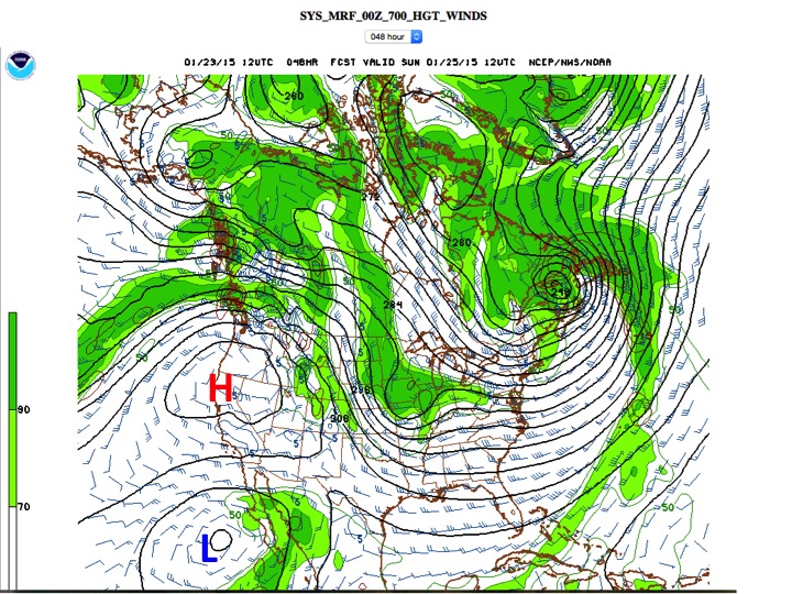
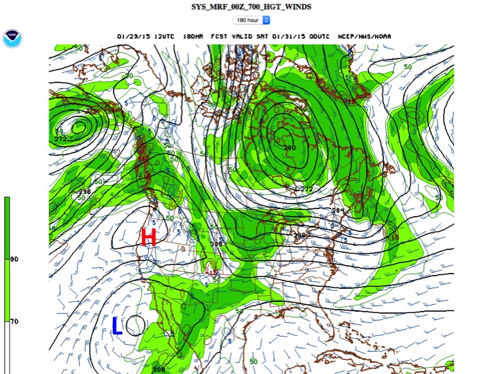
weather Increasing clouds will hint at another ill-defined disturbance passing by to the north though it'll only be a blip on the radar screen before fading off to the east. Temps today will be in the upper 20s to mid-30s. Winds will be a bit breezy along the highest ridgelines from the north and northeast, blowing 25mph and some change. The ridge of high pressure tightens its noose over the intermountain west late in the weekend with 10,000' temps perhaps reaching into the 40s. Surprised? Not as much as our friends in Montana who'll see the same mountain temps as well. Of great interest, however, is a storm brewing off the coast of Baja that ejects inland on a northeasterly track and should move through northern Utah Tues/Wed. At this point, I'm advertising a 3-6" event with a rain/snow line of 7500'+ = higher density snow. OK now the bad news - We're under this weather pattern affectionately known as a Rex Block - as in a storm blocking pattern. It's not good. It generally refers to a pattern of a High Pressure System over (north of) a Low Pressure System. On the left is tomorrow, on the right is next Friday. I've added H for high pressure, L for low pressure.
|
| general announcements
Remember your information can save lives. If you see anything we should know about, please participate in the creation of our own community avalanche advisory by submitting snow and avalanche conditions. You can also call us at 801-524-5304, email by clicking HERE, or include #utavy in your tweet or Instagram. If you trigger an avalanche in the backcountry - especially if you are adjacent to a ski area – please call the following teams to alert them to the slide and whether anyone is missing or not. Rescue teams can be exposed to significant hazard when responding to avalanches, and do not want to do so when unneeded. Thanks. Salt Lake and Park City – Alta Central (801-742-2033), Canyons Resort Dispatch (435-615-3322) Snowbasin Resort Dispatch (801-620-1017), Powder Mountain Dispatch (801-745-3772 x 123). Sundance Dispatch (801-223-4150) EMAIL ADVISORY If you would like to get the daily advisory by email you will need to subscribe here. DAWN PATROL Hotline updated daily by 5-530am - 888-999-4019 option 8. Twitter Updates for your mobile phone - DETAILS UDOT canyon closures: LINK TO UDOT, or on Twitter, follow @UDOTavy, @CanyonAlerts or @AltaCentral Utah Avalanche Center mobile app - Get your advisory on your iPhone along with great navigation and rescue tools. Wasatch Powderbird Guides Blog/Itinerary for the Day. Lost or Found something in the backcountry? - http://nolofo.com/ Discount lift tickets are now available at Backcountry.com. Thanks to Ski Utah and the Utah Resorts. All proceeds go towards paying for Utah Avalanche Center avalanche and mountain weather advisories. To those skinning uphill at resorts: it is your responsibility to know the resort policy on uphill travel. You can see the uphill travel policy for each resort here. IMPORTANT: Before skinning or hiking at a resort under new snow conditions, check in with Ski Patrol. Resorts can restrict or cut off access if incompatible with control and grooming operations. Benefit the Utah Avalanche Center when you shop from Backcountry.com or REI: Click this link for Backcountry.com or this link to REI, shop, and they will donate a percent of your purchase price to the UAC. Both offer free shipping (with some conditions) so this costs you nothing! Benefit the Utah Avalanche Center when you buy or sell on ebay - set the Utah Avalanche Center as a favorite non-profit in your ebay account here and click on ebay gives when you buy or sell. You can choose to have your seller fees donated to the UAC, which doesn't cost you a penny. This information does not apply to developed ski areas or highways where avalanche control is normally done. This advisory is from the U.S.D.A. Forest Service, which is solely responsible for its content. This advisory describes general avalanche conditions and local variations always exist. |


_3.jpg)