| During the month of April, Mark Miller will donate $75 to the charity of your choice (5 to chose from, including the Utah Avalanche Center!) Mark Miller Subaru has raised over $300k in the previous 6 Do Good Feel Good events. More Info here |  |
| During the month of April, Mark Miller will donate $75 to the charity of your choice (5 to chose from, including the Utah Avalanche Center!) Mark Miller Subaru has raised over $300k in the previous 6 Do Good Feel Good events. More Info here | |
| Advisory: Provo Area Mountains | Issued by Evelyn Lees for Saturday - January 17, 2015 - 7:18am |
|---|

|
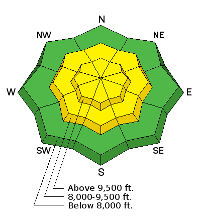
bottom line The avalanche danger is MODERATE today for triggering a wind drift, or wind slab on all mid and upper elevations slopes. The hard, cracky wind drifts will be most widespread on the north through southeasterly facing slopes, in the upper elevation terrain - perhaps pushing a CONSIDERABLE danger in places. But you will be able to find and trigger these wind drifts in the mid elevation terrain, too. Avoid all steep slopes with drifts of wind blown snow and stay well back from the corniced ridge lines. A search for wind sheltered, shady terrain may reward you with both safer terrain and dense, but soft powder.
|
 |
current conditions The skies have cleared and temperatures are dropping, with readings in the teens and low 20 at most elevations in the Provo area mountains. The winds are finally dropping off, too. They have shifted to the northwest, and average speeds have decreased into the 10 to 20 mph range at most locations. Yesterday and overnight, the wind direction varied from southeast to westerly, averaging to 30 mph. The highest peaks had averages to 40 mph, with gusts in the 50s and 60s. A trace to an inch of snow may have fallen overnight in some drainages. The wind has changed the landscape – soft powder will be hard to find in the wind scoured and drifted terrain; the sunny slopes were already covered in breakable crusts. |
 |
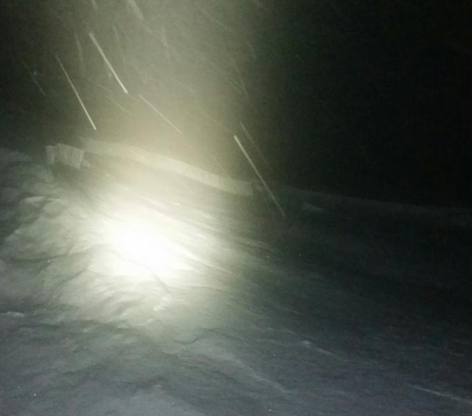
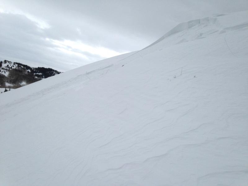
recent activity Yesterday, sensitive wind drifts developed by midday. There were 2 remotely triggered wind slabs off NE facing Little Water peak, about 1 1/2 feet deep, and up to 50’ wide. Another slide was triggered in the evening, down off the ridge line in Alexander, on a NE facing slope at 9200’. This was about 10” deep by 50’ wide. Left photo - Alexander (Hammond) Right photo - smaller wind slab on Little Water (Kendall) Both in the Salt Lake area mountains. ll |
| type | aspect/elevation | characteristics |
|---|

|
|
LIKELIHOOD
 LIKELY
UNLIKELY
SIZE
 LARGE
SMALL
TREND
 INCREASING DANGER
SAME
DECREASING DANGER
|
|
description
Expect to find a tricky mix of both stubborn and sensitive wind slabs today, widespread along the high ridge lines and in upper elevation terrain, more scattered in mid elevation terrain. The stubborn hard slabs will let you get out on to them before breaking above you; the more sensitive wind slabs could be remotely triggered from a distance or from below. While the wind slabs will be most widespread on northeast through southeasterly facing slopes and ridges, look for them on a variety of aspects. Down in open bowls, snow could be loaded near features such as slope breakovers, sub-ridges and gully walls. Cornices will be sensitive, and break back further than expected. Try to identify the wind slabs by sight - by their pillowy, rounded or wavy shapes. Shooting cracks and collapsing are signs you’ve found a wind drift. |
 |
weather High pressure is building back into the area, and there should be a mostly sunny start to the day. Then, clouds will increase again later today and tonight, as another storm passes to the north of the state. Temperatures today will be in the teens at 10,000’ and warm to near 40 at 8,000’. Hopefully, the northwesterly winds will follow the forecast and continue to decrease into the 10 -15 mph range, with only the highest peaks still averaging to 30 mph, and gusting in the 30s and 40s. A series of weak disturbances will bring intermittent clouds and a chance for occasional light snow Sunday through the week. |
| general announcements Remember your information can save lives. If you see anything we should know about, please participate in the creation of our own community avalanche advisory by submitting snow and avalanche conditions. You can also call us at 801-524-5304, email by clicking HERE, or include #utavy in your tweet or Instagram. If you trigger an avalanche in the backcountry - especially if you are adjacent to a ski area – please call the following teams to alert them to the slide and whether anyone is missing or not. Rescue teams can be exposed to significant hazard when responding to avalanches, and do not want to do so when unneeded. Thanks. Salt Lake and Park City – Alta Central (801-742-2033), Canyons Resort Dispatch (435-615-3322) Snowbasin Resort Dispatch (801-620-1017), Powder Mountain Dispatch (801-745-3772 x 123). Sundance Dispatch (801-223-4150) EMAIL ADVISORY If you would like to get the daily advisory by email you will need to subscribe here. DAWN PATROL Hotline updated daily by 5-530am - 888-999-4019 option 8. Twitter Updates for your mobile phone - DETAILS UDOT canyon closures: LINK TO UDOT, or on Twitter, follow @UDOTavy, @CanyonAlerts or @AltaCentral Utah Avalanche Center mobile app - Get your advisory on your iPhone along with great navigation and rescue tools. Wasatch Powderbird Guides Blog/Itinerary for the Day. Lost or Found something in the backcountry? - http://nolofo.com/ Discount lift tickets are now available at Backcountry.com. Thanks to Ski Utah and the Utah Resorts. All proceeds go towards paying for Utah Avalanche Center avalanche and mountain weather advisories. To those skinning uphill at resorts: it is your responsibility to know the resort policy on uphill travel. You can see the uphill travel policy for each resort here. IMPORTANT: Before skinning or hiking at a resort under new snow conditions, check in with Ski Patrol. Resorts can restrict or cut off access if incompatible with control and grooming operations. Benefit the Utah Avalanche Center when you shop from Backcountry.com or REI: Click this link for Backcountry.com or this link to REI, shop, and they will donate a percent of your purchase price to the UAC. Both offer free shipping (with some conditions) so this costs you nothing! Benefit the Utah Avalanche Center when you buy or sell on ebay - set the Utah Avalanche Center as a favorite non-profit in your ebay account here and click on ebay gives when you buy or sell. You can choose to have your seller fees donated to the UAC, which doesn't cost you a penny. This information does not apply to developed ski areas or highways where avalanche control is normally done. This advisory is from the U.S.D.A. Forest Service, which is solely responsible for its content. This advisory describes general avalanche conditions and local variations always exist. |


_3.jpg)