
| During the month of April, Mark Miller will donate $75 to the charity of your choice (5 to chose from, including the Utah Avalanche Center!) Mark Miller Subaru has raised over $300k in the previous 6 Do Good Feel Good events. More Info here |  |
| During the month of April, Mark Miller will donate $75 to the charity of your choice (5 to chose from, including the Utah Avalanche Center!) Mark Miller Subaru has raised over $300k in the previous 6 Do Good Feel Good events. More Info here | |
| Advisory: Provo Area Mountains | Issued by Brett Kobernik for Wednesday - January 14, 2015 - 6:56am |
|---|

|
bottom line There is generally a MODERATE avalanche danger today. The danger of wet avalanches on southerly facing slopes may rise to CONSIDERABLE if the sun heats the newest snow enough. Stay off of and out from under any steep sunny slope that is becoming damp. Continue to be aware of wind slabs in the upper elevation terrain.
|
 |
current conditions Temperatures are in the 15 to 20 degree range this morning and the northeast winds look to be slowing with fairly light speeds. These winds definitely transported some snow during the day on Tuesday and I'd expect more so late afternoon as they picked up in speed for a period. We have mostly clear skies above the low stratus deck that we're seeing from the valley. Many people noted a slight "upside down" feel to the snow yesterday and also noted somewhat difficult trailbreaking. A rime crust also formed on certain slopes in the "white out" up there yesterday. |
 |
recent activity The snow was well behaved for the most part with reports of mostly stable conditions. There were a couple of small skier triggered soft slabs ranging 5 to 12 inches deep and 60 feet at the widest. They were both on an easterly facing aspect and I suspect they were crossloaded terrain features. |
| type | aspect/elevation | characteristics |
|---|

|

|
LIKELIHOOD
 LIKELY
UNLIKELY
SIZE
 LARGE
SMALL
TREND
 INCREASING DANGER
SAME
DECREASING DANGER
|
|
description
Your main concern today is how the new snow reacts to direct sun. It is hard to predict exact timing of this avalanche problem, but, it is easy to avoid. Just stay off of and out from underneath any steep sunny slope where the snow is getting damp. Here are the factors that point to heat related avalanche activity today.
Timing is critical. Plan your route accordingly so you don't wind up on or below a slope that has seen too much heating from the sun. This set up can catch backcountry "rookies" off guard. |
| type | aspect/elevation | characteristics |
|---|

|

|
LIKELIHOOD
 LIKELY
UNLIKELY
SIZE
 LARGE
SMALL
TREND
 INCREASING DANGER
SAME
DECREASING DANGER
|
|
description
I suspect most of the wind slabs will be pretty stubborn today but you should still consider them a potential problem. The predominant direction over the last 24 hours was northeast so it stands to reason that snow was transported onto west facing slopes. However, you need to watch for crossloaded terrain features on all aspects in the higher terrain. |
 |
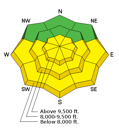
weather We are anticipating clear skies in the mountains today with ridgetop temperatures in the 20s and near freezing at 8000 feet. Winds will be fairly light from the north. Temperatures will be warmer on Thursday with moderate speed westerly winds. Temperatures cool slightly on Friday then a brush-by storm might bring a few flurries Friday night into Saturday. |
| general announcements Remember your information can save lives. If you see anything we should know about, please participate in the creation of our own community avalanche advisory by submitting snow and avalanche conditions. You can also call us at 801-524-5304, email by clicking HERE, or include #utavy in your tweet or Instagram. If you trigger an avalanche in the backcountry - especially if you are adjacent to a ski area – please call the following teams to alert them to the slide and whether anyone is missing or not. Rescue teams can be exposed to significant hazard when responding to avalanches, and do not want to do so when unneeded. Thanks. Salt Lake and Park City – Alta Central (801-742-2033), Canyons Resort Dispatch (435-615-3322) Snowbasin Resort Dispatch (801-620-1017), Powder Mountain Dispatch (801-745-3772 x 123). Sundance Dispatch (801-223-4150) EMAIL ADVISORY If you would like to get the daily advisory by email you will need to subscribe here. DAWN PATROL Hotline updated daily by 5-530am - 888-999-4019 option 8. Twitter Updates for your mobile phone - DETAILS UDOT canyon closures: LINK TO UDOT, or on Twitter, follow @UDOTavy, @CanyonAlerts or @AltaCentral Utah Avalanche Center mobile app - Get your advisory on your iPhone along with great navigation and rescue tools. Wasatch Powderbird Guides Blog/Itinerary for the Day. Lost or Found something in the backcountry? - http://nolofo.com/ Discount lift tickets are now available at Backcountry.com. Thanks to Ski Utah and the Utah Resorts. All proceeds go towards paying for Utah Avalanche Center avalanche and mountain weather advisories. To those skinning uphill at resorts: it is your responsibility to know the resort policy on uphill travel. You can see the uphill travel policy for each resort here. IMPORTANT: Before skinning or hiking at a resort under new snow conditions, check in with Ski Patrol. Resorts can restrict or cut off access if incompatible with control and grooming operations. Benefit the Utah Avalanche Center when you shop from Backcountry.com or REI: Click this link for Backcountry.com or this link to REI, shop, and they will donate a percent of your purchase price to the UAC. Both offer free shipping (with some conditions) so this costs you nothing! Benefit the Utah Avalanche Center when you buy or sell on ebay - set the Utah Avalanche Center as a favorite non-profit in your ebay account here and click on ebay gives when you buy or sell. You can choose to have your seller fees donated to the UAC, which doesn't cost you a penny. This information does not apply to developed ski areas or highways where avalanche control is normally done. This advisory is from the U.S.D.A. Forest Service, which is solely responsible for its content. This advisory describes general avalanche conditions and local variations always exist. |


_3.jpg)